Home / Editor's Pick /

Storm Amy: damage assessment from the weekend – damage across Europe

08:53
6 October 2025

Damage across Europe
Storm Amy's weekend impacts

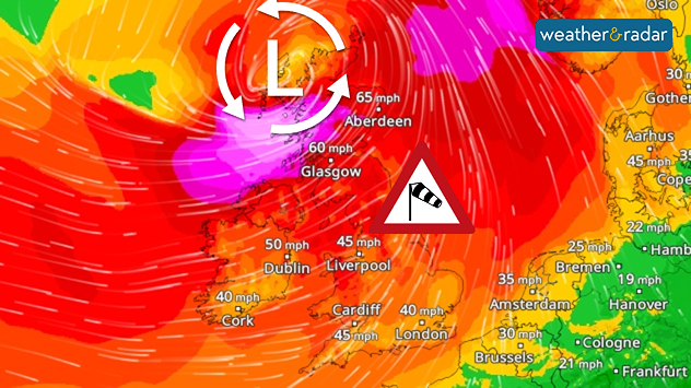
The image illustrates the effects of a severe storm system over north-western Europe: the map shows the weather situation with a storm warningWindRadar for Friday.

On Friday, into the weekend, a low-pressure system wreaked havoc in several European countries, with the strongest impacts in the UK and Norway.

Heavy rain spread across the UK and Ireland as the first named storm of the season moved through, with intense gales in places.

The strongest gusts were recorded in Norway and Scotland:

Wind peakPlace
138 miles per hourMannen, Norway
109 miles per hourCairnwell, Scotland
89 miles per hourJuvvasshoe, Norway

In both countries, and in Europe, there were power outages, road closures and disruptions to air and rail traffic. Tens of thousands were without power, and parks in London were closed as a precautionary measure.

The toll was particularly tragic in France and Ireland: in Normandy, two men died in connection with the storm, one of them while swimming despite the high warning level. In the municipality of Hervilly in north-western France, an entire roof was torn off.

Settings for external content

Privacy Policy

In the Netherlands, around 150 flights were cancelled at Amsterdam Schiphol Airport on Saturday. Ferry services to the Wadden Islands were also cancelled.

Verena Leyendecker
Ryan Hathaway
More on the topic
Split image showing an alpine winter landscape and a European weather map with snow and rain areas.
Monday, 1 December 2025

Winter begins today

Wintry weather only in a few places
Split image showing a night-time waterfall beneath sweeping star trails on the left, and a bright double rainbow over a calm lakeside with mountains, pier, and mist on the right.
Sunday, 30 November 2025

Your weather - Your shots

From rainbow light to starlight
A split image showing a close-up of a full moon on the left, and on the right a UK and Ireland weather map with blue and white patches indicating widespread rain or cloud. Several moon and cloud icons appear over different regions, with temperatures marked mostly between 4°C and 8°C.
Thursday, 4 December 2025

Cold Moon rises tonight

Third and final supermoon of the year
All weather news
This might also interest you
Weather map of the UK and Ireland showing scattered showers with cloudy patches across much of the region, especially around western and northern areas. Sunshine symbols appear over London, Cardiff, and parts of southern England, while temperatures range from 17°C to 18°C in most places. Areas of heavier rain are visible over the Atlantic to the west.
Friday, 29 August 2025

Breakfast brief

Unsettled conditions into the weekend
plit image showing a double rainbow over a rocky shoreline on the left and sheep grazing in a green field under stormy clouds on the right.
Sunday, 2 November 2025

Your weather - Your shots

Mixed conditions on an unsettled week
Split weather map showing UK wind speeds in orange-red shades up to 40 mph on the left and warning levels in green-yellow on the right, with a central wind warning sign.
Wednesday, 22 October 2025

Warnings active

Storm Benjamin impacts the UK
All articles
Weather & Radar

Weather & Radar is also available on

Google Play StoreApp Store

Company

Contact us Privacy Policy Legal info Accessibility statement

Services

Uploader

Socials

facebooktwittertikToklinkList