Home
Weather London
WeatherRadar
RainfallRadar
TemperatureRadar
WindRadar
LightningRadar
Weather News
Editor's Pick
Discover the app
Weather widget
Contact us
Apps
Career
    Home / Editor's Pick /

    Storm Amy: damage assessment from the weekend – damage across Europe

08:53
6 October 2025

Damage across Europe
Storm Amy's weekend impacts

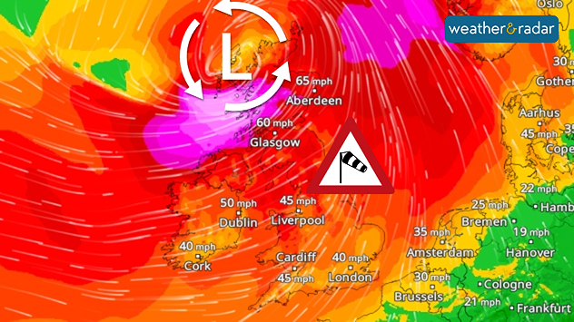
The image illustrates the effects of a severe storm system over north-western Europe: the map shows the weather situation with a storm warning
WindRadar for Friday.

On Friday, into the weekend, a low-pressure system wreaked havoc in several European countries, with the strongest impacts in the UK and Norway.

Heavy rain spread across the UK and Ireland as the first named storm of the season moved through, with intense gales in places.

The strongest gusts were recorded in Norway and Scotland:

Wind peakPlace
138 miles per hourMannen, Norway
109 miles per hourCairnwell, Scotland
89 miles per hourJuvvasshoe, Norway

In both countries, and in Europe, there were power outages, road closures and disruptions to air and rail traffic. Tens of thousands were without power, and parks in London were closed as a precautionary measure.

The toll was particularly tragic in France and Ireland: in Normandy, two men died in connection with the storm, one of them while swimming despite the high warning level. In the municipality of Hervilly in north-western France, an entire roof was torn off.

Privacy Policy

In the Netherlands, around 150 flights were cancelled at Amsterdam Schiphol Airport on Saturday. Ferry services to the Wadden Islands were also cancelled.

Verena Leyendecker
Ryan Hathaway
More on the topic
Extreme weather contrasts in Europe. Heat versus constant rain. . . Thursday, 3 September 2026
On the left, the Temperature Radar shows high temperatures in Spain; on the right, the Weather Radar shows rain in Central Europe
Thursday, 3 September 2026

Heat versus constant rain

Extreme weather contrasts in Europe
Cheshire Gap produces shower funnel. Local phenomenon. . . Wednesday, 9 September 2026
Weather map showing showers moving southeast from Liverpool toward Birmingham, driven by Cheshire Gap convergence across central England.
Wednesday, 9 September 2026

Local phenomenon

Cheshire Gap produces shower funnel
Severe weather in southern Europe. Thunderstorms & heavy rain. . . Wednesday, 9 September 2026
On the left, dark storm clouds over a coastline. On the right, a weather map shows thunderstorms over the western Mediterranean, with warning symbols for tornadoes, storms and hail.
Wednesday, 9 September 2026

Thunderstorms & heavy rain

Severe weather in southern Europe
All weather news
This might also interest you
Historic Storm Éowyn arrives. On this day.... . . Saturday, 24 January 2026
Split image showing a person in a yellow jacket struggling against strong winds and heavy rain on a street at night on the left, and an Irish wind forecast map on the right with red and purple shading, gusts up to 75 mph, and a wind warning icon, divided by a curved white line.
Saturday, 24 January 2026

On this day...

Historic Storm Éowyn arrives
New records for England and Wales. Broken again tomorrow?. . . Thursday, 25 June 2026
Temperature map of southwest Britain on 25.06 showing extreme heat across southern Wales and southwest England, with Bute Park in Cardiff highlighted at 34.2°C and Yeovilton at 36.4°C amid widespread deep red heat zones.
Thursday, 25 June 2026

Broken again tomorrow?

New records for England and Wales
A stormy week in the skies above. Your weather - Your shots. . . Sunday, 30 August 2026
Split image showing lightning branching beneath dark storm clouds above rooftops on the left and an orange-pink sunset over a calm sea on the right.
Sunday, 30 August 2026

Your weather - Your shots

A stormy week in the skies above
All articles
Weather & Radar

Weather & Radar is also available on

Google Play StoreApp Store

Company

Contact us Privacy Policy Legal info Accessibility statement

Services

Uploader

Socials

facebooktwittertikToklinkList