Home
Weather London
WeatherRadar
RainfallRadar
TemperatureRadar
WindRadar
LightningRadar
Weather News
Editor's Pick
Discover the app
Weather widget
Contact us
Apps
Career
    Home / Editor's Pick /

    Storm AMY arriving on Friday

13:26
2 October 2025

Disruption likely
Storm "AMY" arriving on Friday

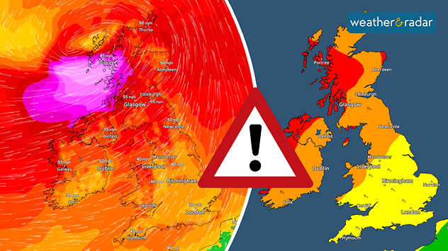
A very deep low pressure area will bring strong winds to parts of the UK and Ireland.

Storm AMY is developing into a very strong low pressure system, bringing severe gales to parts of Ireland and the UK on Friday and Saturday.

Latest models confirm the track and evolution of this unseasonally deep low, moving just to the north of Ireland and then Scotland Friday and Friday night.

Ireland will see winds strengthen through the day, while Scotland bears the brunt late Friday into the night.

Peak gusts could reach 70 to 80 mph along northern Irish coasts and even 90 to 100 mph in some parts of western Scotland.

Elsewhere, winds may still reach 45 to 60 mph, especially in coastal and upland areas.

Meanwhile, further spells of heavy rain associated both with Storm AMY and other frontal systems could lead to localised flooding.

Both the rain and the severe gales are very likely to lead to disruption and damage across the far north of Ireland and parts of Scotland, including to road, rail and air traffic.

There may be power cuts and some coastal locations could be affected by large waves.

How to activate warningsread more
Lars Lowinski
More on the topic
Severe damage along the Adriatic coast. Huge hail and storms. . . Wednesday, 22 July 2026
Two hands are holding huge hailstones; next to them is a weather map showing thunderstorms and frequent lightning over the Adriatic coast and the western Balkans.
Wednesday, 22 July 2026

Huge hail and storms

Severe damage along the Adriatic coast
Long-term trends need a pinch of salt. Heading over 40°C?. . . Tuesday, 21 July 2026
Temperature radar of 2022 heatwave where the all-time temperature record in the UK was set. Warning symbol overlain.
Tuesday, 21 July 2026

Heading over 40°C?

Long-term trends need a pinch of salt
Heatwave breaks after remarkable run. Two weeks of heat. . . Monday, 20 July 2026
Split image showing the London skyline in hazy golden sunshine on the left and a July temperature anomaly map of Europe on the right, with above-average temperatures across the UK, Ireland, and much of western Europe highlighted in red alongside a thermometer icon.
Monday, 20 July 2026

Two weeks of heat

Heatwave breaks after remarkable run
All weather news
This might also interest you
Flooding, gales, and heavy snow. Storm Chandra. . . Tuesday, 27 January 2026
Split image showing aerial flooding in a town with muddy water covering roads on the left, and a rural road on the right blocked by heavy snowfall with vans stopped and a person walking in snow.
Tuesday, 27 January 2026

Storm Chandra

Flooding, gales, and heavy snow
Seasonal warmth between spring thunder. Your weather - Your shots. . . Sunday, 19 April 2026
Split image showing coastal sunset with layered lenticular clouds over rooftops and palm trees on the left, and a green valley with river and hills under soft daylight on the right.
Sunday, 19 April 2026

Your weather - Your shots

Seasonal warmth between spring thunder
A frozen start to the weekend. Icy conditions. . . Friday, 13 February 2026
UK temperature map dated 14.02 showing widespread subzero values in blue shading, with readings such as −4 in Glasgow, −3 in Dublin, and −2 in London, alongside a blue thermometer icon.
Friday, 13 February 2026

Icy conditions

A frozen start to the weekend
All articles
Weather & Radar

Weather & Radar is also available on

Google Play StoreApp Store

Company

Contact us Privacy Policy Legal info Accessibility statement

Services

Uploader

Socials

facebooktwittertikToklinkList