Home
Weather London
WeatherRadar
RainfallRadar
TemperatureRadar
WindRadar
LightningRadar
Weather News
Editor's Pick
Discover the app
Weather widget
Contact us
Apps
Career
    Home / Editor's Pick /

    Storm AMY arriving on Friday

13:26
2 October 2025

Disruption likely
Storm "AMY" arriving on Friday

A very deep low pressure area will bring strong winds to parts of the UK and Ireland.

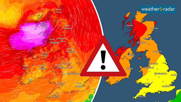
Storm AMY is developing into a very strong low pressure system, bringing severe gales to parts of Ireland and the UK on Friday and Saturday.

Latest models confirm the track and evolution of this unseasonally deep low, moving just to the north of Ireland and then Scotland Friday and Friday night.

Ireland will see winds strengthen through the day, while Scotland bears the brunt late Friday into the night.

Peak gusts could reach 70 to 80 mph along northern Irish coasts and even 90 to 100 mph in some parts of western Scotland.

Elsewhere, winds may still reach 45 to 60 mph, especially in coastal and upland areas.

Meanwhile, further spells of heavy rain associated both with Storm AMY and other frontal systems could lead to localised flooding.

Both the rain and the severe gales are very likely to lead to disruption and damage across the far north of Ireland and parts of Scotland, including to road, rail and air traffic.

There may be power cuts and some coastal locations could be affected by large waves.

How to activate warningsread more
Lars Lowinski
More on the topic
Split image showing a bright rainbow above a residential street on the left and a dramatic ocean sunrise with glowing clouds and reflections on the sea on the right.
Sunday, 24 May 2026

Your weather - Your shots

From unsettled to warm and toasty
Weather warning map of Wales and western Britain showing a yellow thunderstorm alert with lightning symbols, alongside a large warning triangle for lightning.
Wednesday, 27 May 2026

Wales & western England

Thunderstorm watch continues
Split image showing a European weather map with low-pressyre system, temperature bands, and thunderstorm icon on the left, and a bright rainbow over green countryside and mountains on the right.
Wednesday, 27 May 2026

Early summer ends

A change in the weather is on the way
All weather news
This might also interest you
Split image showing a person in a yellow jacket struggling against strong winds and heavy rain on a street at night on the left, and an Irish wind forecast map on the right with red and purple shading, gusts up to 75 mph, and a wind warning icon, divided by a curved white line.
Saturday, 24 January 2026

On this day...

Historic Storm Éowyn arrives
Weather graphic showing rain and wind fields over the Canary Islands and a central warning symbol.
Friday, 12 December 2025

Storm and rain

Turbulent weather in the Canary Islands
UK temperature map dated 14.02 showing widespread subzero values in blue shading, with readings such as −4 in Glasgow, −3 in Dublin, and −2 in London, alongside a blue thermometer icon.
Friday, 13 February 2026

Icy conditions

A frozen start to the weekend
All articles
Weather & Radar

Weather & Radar is also available on

Google Play StoreApp Store

Company

Contact us Privacy Policy Legal info Accessibility statement

Services

Uploader

Socials

facebooktwittertikToklinkList