Home
Weather London
WeatherRadar
RainfallRadar
TemperatureRadar
WindRadar
LightningRadar
Weather News
Editor's Pick
Discover the app
Weather widget
Contact us
Apps
Career
    Home / Editor's Pick /

    Staying safe: Do you know how to prepare for a flood?

06:00
9 November 2022

Staying safe
Do you know how to prepare for a flood?

Flooding

When a flood warning is issued, are you aware of how to react?

Since 1998 the UK has seen six of the 10 wettest years on record, when severe rainfall hits and flooding develops it is imperative that you know how best to behave for safety.

Before you can react to any warning, you need to receive them. The Environment Agency offers a free flood warning service, currently covering 1.6 million properties, which will alert you of any danger.

There are three levels in the UK: Flood alert, flood warning, and severe flood warning. For an alert, prepare an emergency bag containing medicine and any insurance documents.

In a warning, disconnect your utilities, take any vehicles to higher ground, and move upstairs or to a high point of safety.

Severe warnings generally coincide with evacuation orders, do not waste any time and follow advice from emergency services.

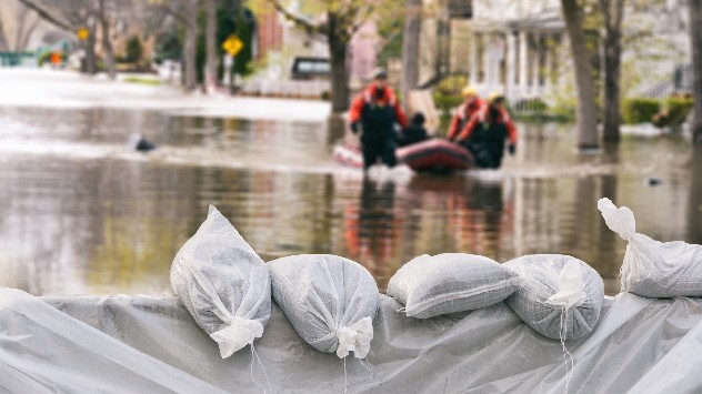
You can contact your local council for help obtaining sandbags to better secure your property, as well as surrounding the perimeter, the Red Cross also suggest placing a bag in toilet bowls to avoid sewage back flow.

Once a flood strikes, remain in place. Water can be deceptively dangerous, just six inches of fast flowing water can knock a person over and sewage contamination brings other dangers.

The government has committed £5.2 billion to flood and coastal defences, which will help protect an additional 336,000 properties by 2027.

Research published in 2022 by the Environment Agency revealed that two in three households at risk of being flooded do not believe it will happen to them. If it does, be prepared.

There are currently multiple flood alerts in effect, if you are covered by an alert be sure to check the WeatherRadar and plan accordingly.

Ryan Hathaway
More on the topic
Half of England now in drought. Joining North Wales. . . Wednesday, 29 July 2026
Dry section of the River Thames beneath a small stone bridge, with the riverbed exposed and cracked after prolonged, dry weather, while a person walks along the roadside above.
Wednesday, 29 July 2026

Joining North Wales

Half of England now in drought
Icy spells in the Southern Hemisphere. Snow in the Andes. . . Tuesday, 28 July 2026
A composite image showing a temperature radar map of South America and a snow-covered town in Chile. The winter cold is bringing heavy snowfall to the Andes and, in some areas, snow down to lower altitudes.
Tuesday, 28 July 2026

Snow in the Andes

Icy spells in the Southern Hemisphere
Floods and landslides in parts of Asia. An unusual monsoon. . . Wednesday, 29 July 2026
Split image: On the left, flooded villages and fields can be seen in a vast landscape. On the right, a weather map of India shows heavy rainfall, along with a warning sign featuring a car in floodwater.
Wednesday, 29 July 2026

An unusual monsoon

Floods and landslides in parts of Asia
All weather news
This might also interest you
Storm Chandra makes impact. Severe gales & heavy rain. . . Tuesday, 27 January 2026
Split image showing strong winds over the UK on a forecast map and widespread rain and snow on a weather radar map.
Tuesday, 27 January 2026

Severe gales & heavy rain

Storm Chandra makes impact
Super Typhoon Bavi threatens Taiwan. Up to 1,000 mm of rain. . . Wednesday, 8 July 2026
The image shows an intense tropical cyclone over the western Pacific, east of Taiwan and the Philippines. The centre of the system is depicted as a light purple and white vortex with a clearly visible eye, surrounded by a ring of red and orange areas indicating the strongest wind speeds. A white arrow marks the typhoon’s predicted track towards the north-west, in the direction of Taiwan. To the west of the storm lie the Philippines, with the cities of Manila and Cebu; to the north of these lies Taiwan, with Taipei. Further west, the Chinese coast, including Hong Kong, and parts of Vietnam can be seen. The coloured wind map shows predominantly green areas outside the storm’s core, indicating significantly weaker winds. White streamlines illustrate the typhoon’s anti-clockwise circulation in the Northern Hemisphere. The highest wind speeds are concentrated around the eye of the cyclone.
Wednesday, 8 July 2026

Up to 1,000 mm of rain

Super Typhoon Bavi threatens Taiwan
Bright and warm conditions take hold. Spring-like outlook. . . Thursday, 23 April 2026
Split UK map showing warm temperatures up to 21 degrees in orange on the left and clear sunny conditions with temperatures from 12 to 18 degrees on the right, with sun icons across the country.
Thursday, 23 April 2026

Spring-like outlook

Bright and warm conditions take hold
All articles
Weather & Radar

Weather & Radar is also available on

Google Play StoreApp Store

Company

Contact us Privacy Policy Legal info Accessibility statement

Services

Uploader

Socials

facebooktwittertikToklinkList