Home
Weather London
WeatherRadar
RainfallRadar
TemperatureRadar
WindRadar
LightningRadar
Weather News
Editor's Pick
Discover the app
Weather widget
Contact us
Apps
Career
    Home / Editor's Pick /

    Spotted in the UK: Incredible display of aurora

10:01
28 September 2022

Spotted in the UK
Incredible display of aurora

Privacy Policy

On September 26th, parts of Canada, North America, Scandinavia and even the UK were blessed by an un expected northern lights display.

People were caught by surprise on Monday night when they went outdoors to photograph Jupiter, but instead captured a jaw-dropping display of aurora overhead.

NOAA's Space Center predicted visibility as far south as 50 degrees N, with people capturing the aurora as far south as Bulmer in North Yorkshire, at about 54 degrees N.

This was due to a sudden spike in solar activity, the result of a CME (coronal mass ejection). It consequently disturbed our magnetic field, producing the brilliant display of aurora.

Aurora can be difficult to spot with the naked eye, but beautifully photographed with a few handy tips:

  • Long exposure is critical; often around 12-20 seconds, though some may need nearer to 30 seconds
  • Use a tripod to keep your camera still
  • Avoid being around external light sources
  • A fast aperture of minimum f4, but ideally f2.8
  • The higher the ISO, the more light you capture, but the grainier the shot
  • Clear skies are needed - check our WeatherRadar for cloud cover

The spectacular colours can be attributed to the gases present in the atmosphere. Green is associated with oxygen, whilst purple, blue, or pink are typical with nitrogen.

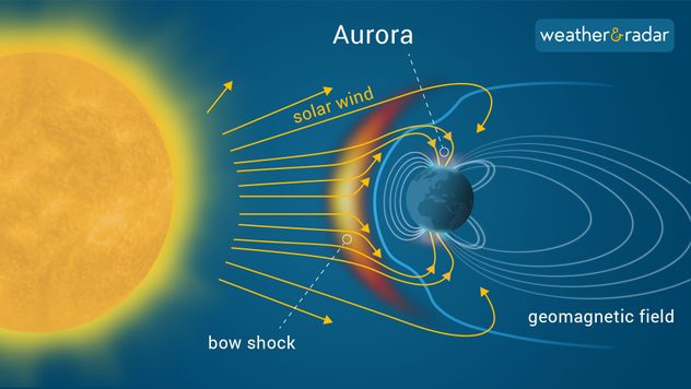
Auroras are caused when the sun ejects significant amounts of particles towards Earth, during periods of heightened solar activity.

This material then interacts with the Earth's magnetic fields and the gases in our atmosphere, producing the display.

aurora infographic

If you've ever managed to capture this breathtaking phenomenon, send in your photos to our uploader here.

Weather & Radar editorial team
More on the topic
A wet start before conditions settle. Commonwealth Games 2026. . . Wednesday, 22 July 2026
Split image showing a weather map for western Scotland with widespread rain around Glasgow on the left, and runners poised at a starting line on an athletics track on the right.
Wednesday, 22 July 2026

Commonwealth Games 2026

A wet start before conditions settle
Long-term trends need a pinch of salt. Heading over 40°C?. . . Tuesday, 21 July 2026
Temperature radar of 2022 heatwave where the all-time temperature record in the UK was set. Warning symbol overlain.
Tuesday, 21 July 2026

Heading over 40°C?

Long-term trends need a pinch of salt
New heatwave in southern Europe. Up to 45 degrees in Spain. . . Tuesday, 21 July 2026
Split temperature map showing extreme heat across Spain on the left and Greece on the right, with temperatures reaching 44°C near Murcia, around 40°C in parts of Greece, and a large thermometer icon highlighting dangerous heat.
Tuesday, 21 July 2026

Up to 45 degrees in Spain

New heatwave in southern Europe
All weather news
This might also interest you
Super Typhoon Bavi threatens Taiwan. Up to 1,000 mm of rain. . . Wednesday, 8 July 2026
The image shows an intense tropical cyclone over the western Pacific, east of Taiwan and the Philippines. The centre of the system is depicted as a light purple and white vortex with a clearly visible eye, surrounded by a ring of red and orange areas indicating the strongest wind speeds. A white arrow marks the typhoon’s predicted track towards the north-west, in the direction of Taiwan. To the west of the storm lie the Philippines, with the cities of Manila and Cebu; to the north of these lies Taiwan, with Taipei. Further west, the Chinese coast, including Hong Kong, and parts of Vietnam can be seen. The coloured wind map shows predominantly green areas outside the storm’s core, indicating significantly weaker winds. White streamlines illustrate the typhoon’s anti-clockwise circulation in the Northern Hemisphere. The highest wind speeds are concentrated around the eye of the cyclone.
Wednesday, 8 July 2026

Up to 1,000 mm of rain

Super Typhoon Bavi threatens Taiwan
A frozen start to the weekend. Icy conditions. . . Friday, 13 February 2026
UK temperature map dated 14.02 showing widespread subzero values in blue shading, with readings such as −4 in Glasgow, −3 in Dublin, and −2 in London, alongside a blue thermometer icon.
Friday, 13 February 2026

Icy conditions

A frozen start to the weekend
New records for England and Wales. Broken again tomorrow?. . . Thursday, 25 June 2026
Temperature map of southwest Britain on 25.06 showing extreme heat across southern Wales and southwest England, with Bute Park in Cardiff highlighted at 34.2°C and Yeovilton at 36.4°C amid widespread deep red heat zones.
Thursday, 25 June 2026

Broken again tomorrow?

New records for England and Wales
All articles
Weather & Radar

Weather & Radar is also available on

Google Play StoreApp Store

Company

Contact us Privacy Policy Legal info Accessibility statement

Services

Uploader

Socials

facebooktwittertikToklinkList