Home
Weather London
WeatherRadar
RainfallRadar
TemperatureRadar
WindRadar
LightningRadar
Weather News
Editor's Pick
Discover the app
Weather widget
Contact us
Apps
Career
    Home / Editor's Pick /

    Solomon Islands and Fiji: Cyclones threaten South Pacific islands

10:09
6 April 2026

Solomon Islands and Fiji
Cyclones threaten South Pacific islands

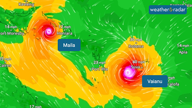
WindRadar: Two cyclones are currently threatening the South Sea islands off the coast of Australia.

On the South Sea islands east of Australia: between the Fiji Islands and the neighbouring state of Vanuatu, Cyclone Vaianu is sweeping across the South Pacific.

Meanwhile, Cyclone Maila is making its way near the Solomon Islands. Both storms are accompanied by gale-force winds and torrential rain.

In Fiji, the authorities have issued warnings of gusts of wind, flash floods and flooding. Schools and universities remain closed. Low-lying areas are particularly at risk. Vaianu is expected to strengthen into a Category 3 cyclone during the course of Tuesday.

Although the eye of the storm will pass over the sea between Fiji and Vanuatu, the authorities remain on high alert. It was only in 2020 that the devastating Cyclone Yasu caused severe damage to the island nation and claimed several lives.

Cyclone Maila off the Solomon Islands, on the other hand, shows little sign of moving for the time being. However, it is expected to move westwards towards the Australian coast in the coming days.

Jürgen Vollmer
More on the topic
Heavier rainfall over the week for some. Ireland & Scotland. . . Tuesday, 28 July 2026
Split image showing a Europe rainfall accumulation forecast map on the left with the highest totals across the UK, Ireland, and Scandinavia, and a satellite weather map on the right with a broad band of rain stretching across Ireland, Scotland, and northern Britain, highlighted by a rain cloud icon.
Tuesday, 28 July 2026

Ireland & Scotland

Heavier rainfall over the week for some
Rain returns to end dry spell in places. Jet stream delivery. . . Thursday, 23 July 2026
Split weather graphic showing widespread showers across the UK and Ireland on the left, and a wind forecast map on the right with a windsock icon and gusts of 25 to 35 mph, highlighting breezy conditions across the two countries.
Thursday, 23 July 2026

Jet stream delivery

Rain returns to end dry spell in places
Clouds return to capture the scene. Your weather - Your shots. . . Sunday, 26 July 2026
Waxing crescent Moon above vivid pink and magenta sunset clouds, with silhouetted trees along the horizon beneath a deepening blue twilight sky.
Sunday, 26 July 2026

Your weather - Your shots

Clouds return to capture the scene
All weather news
This might also interest you
Bright and warm conditions take hold. Spring-like outlook. . . Thursday, 23 April 2026
Split UK map showing warm temperatures up to 21 degrees in orange on the left and clear sunny conditions with temperatures from 12 to 18 degrees on the right, with sun icons across the country.
Thursday, 23 April 2026

Spring-like outlook

Bright and warm conditions take hold
Seasonal warmth between spring thunder. Your weather - Your shots. . . Sunday, 19 April 2026
Split image showing coastal sunset with layered lenticular clouds over rooftops and palm trees on the left, and a green valley with river and hills under soft daylight on the right.
Sunday, 19 April 2026

Your weather - Your shots

Seasonal warmth between spring thunder
Long-term trends need a pinch of salt. 40 °C in July?. . . Tuesday, 30 June 2026
Temperature radar of 2022 heatwave where the all-time temperature record in the UK was set. Warning symbol overlain.
Tuesday, 30 June 2026

40 °C in July?

Long-term trends need a pinch of salt
All articles
Weather & Radar

Weather & Radar is also available on

Google Play StoreApp Store

Company

Contact us Privacy Policy Legal info Accessibility statement

Services

Uploader

Socials

facebooktwittertikToklinkList