Home
Weather London
WeatherRadar
RainfallRadar
TemperatureRadar
WindRadar
LightningRadar
Weather News
Editor's Pick
Discover the app
Weather widget
Contact us
Apps
Career
    Home / Editor's Pick /

    Solar winds arrive: Auroras to return to Scotland overnight

12:41
30 March 2023

Solar winds arrive
Auroras to return to Scotland overnight

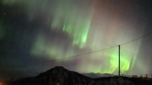
Aurora borealis
February's aurora seen in Talmine, Scotland by a Weather & Radar user. - © Dawn Gibson-Hylands

A fresh display of the Northern Lights is expected to reach the UK this evening after the emergence of a colossal coronal hole on the Sun’s surface.

After a stunning display of the Aurora Borealis just weeks ago, speeding solar winds will again produce a display of the natural phenomenon.

On Monday, NASA’s Solar Dynamics Observatory reported a large coronal hole wide enough to fit 20 Earths within. These holes allow the release of solar particles which race towards the planet and interact with our atmosphere creating auroras.

Solar winds with speeds of up to 1.3 million mph are being released through the hole and reach Earth tonight. The NOAA suggest a peak of 4.33 on the KP-Index scale indicating an active auroral display.

KP-Index u0026 G-classes

The KP-Index is used to measure geomagnetic activity and ranges from 0 to 9.

This evening’s display is likely to be limited to the north of Scotland. Unlike that seen recently which reached as far south as continental Europe.

Classed as a moderate G2-class geomagnetic storm at this level the winds will have minimal impacts though stronger classes can disrupt GPS, satellites, and radio services.

The Sun is approaching its most active stage of the 11-year solar cycle making our nearest star more volatile.

As this cycle peaks in 2025 we can expect more common, and more intense, solar storms leading to vibrant auroras.

This time around, those in the north of Scotland are the only ones likely to see the display with chances tonight and Friday night. Don’t get caught out by the weather, check the WeatherRadar for visibility before heading out.

Ryan Hathaway
More on the topic
Split image showing a tranquil reservoir at sunset with rolling hills on the left, and a dramatic cloud illuminated by crepuscular sun rays above a tree-lined horizon on the right.
Sunday, 31 May 2026

Your weather - Your shots

Cooler views after the week's heat
Heat map centered on London showing intense red temperatures across southeast England, with Heathrow highlighted at 33.5°C and nearby cities around 30–32°C.
Monday, 25 May 2026

33.5 °C and still rising

Hottest May day on record
Temperature map of southeast England showing overnight low temperatures, with Kenley highlighted at 21.3°C and surrounding areas in yellow-orange shades indicating mild nighttime conditions.
Tuesday, 26 May 2026

May heatwave

Tropical night breaks overnight record
All weather news
This might also interest you
plit image showing a double rainbow over a rocky shoreline on the left and sheep grazing in a green field under stormy clouds on the right.
Sunday, 2 November 2025

Your weather - Your shots

Mixed conditions on an unsettled week
Outline of Santa Claus with a yellow and white hat, "Ho-Ho-Ho" next to the outline above a Christmas tree.
Thursday, 25 December 2025

Merry Christmas!

Wishes from Weather & Radar
Split image showing a person in a yellow jacket struggling against strong winds and heavy rain on a street at night on the left, and an Irish wind forecast map on the right with red and purple shading, gusts up to 75 mph, and a wind warning icon, divided by a curved white line.
Saturday, 24 January 2026

On this day...

Historic Storm Éowyn arrives
All articles
Weather & Radar

Weather & Radar is also available on

Google Play StoreApp Store

Company

Contact us Privacy Policy Legal info Accessibility statement

Services

Uploader

Socials

facebooktwittertikToklinkList