Home
Weather London
WeatherRadar
RainfallRadar
TemperatureRadar
WindRadar
LightningRadar
Weather News
Editor's Pick
Discover the app
Weather widget
Contact us
Apps
Career
    Home / Editor's Pick /

    Snow cannons at work: Artificial snow for winter sports

Snow cannons at work
Artificial snow for winter sports

Snow cannon
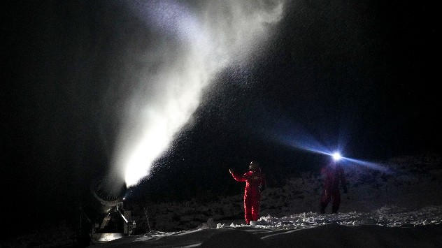
Snow cannon at work at the Changbai Mountain Ski Resort. - © picture alliance

Snow cannons are widely used around the world where natural snow is insufficient, for the likes of the Beijing Olympics and Paralympics back in 2022.

China saw its warmest year on record in 2022 and as a result experienced drought conditions. Despite some natural snow at high altitudes, widespread use of artificial snow was needed for the winter Olympic sports.

High-pressure conditions, with clear and cold nights, are ideal for the production of artificial snow which is created by firing small water droplets into the air where they freeze and fall to the ground.

Additional nucleators are often added to the water, which helps ice crystals form faster.

Artificial snow lasts longer than the real thing but provides a heavier feel for skiers due to the higher water content.

The use of snow cannons is increasingly popular, with more than 60% of the world’s ski resorts now using them to supplement a decreasing amount of natural snowfall.

Using artificial snow is nothing new for the Winter Olympics, however. The first time it was used was in 1980 in Lake Placid, New York, USA, when a dry winter produced less snow than normal.

In addition to the ongoing drought, climate change has influenced the need for artificial snow on the slopes.

To make and provide artificial snow, officials used water from nearby reservoirs known as Foyukou and Baihepu.

Snowfarming in Switzerlandread more
Weather & Radar editorial team

This might also interest you

Severe weather risk in the Mediterranean. Turkey and Greece. . . Tuesday, 27 October 2026
Weather map showing low pressure over the Aegean Sea, blue rain bands across Greece and Turkey, and heavy rain and thunderstorm warning symbols.
Tuesday, 27 October 2026

Turkey and Greece

Severe weather risk in the Mediterranean
Stormy winds finally easing. By the end of the week. . . Tuesday, 27 October 2026
Split wind maps showing winds of 25–40 mph across the UK and Ireland easing to 7–15 mph, with a white arrow indicating the change.
Tuesday, 27 October 2026

By the end of the week

Stormy winds finally easing
Wettest week in England for two years. Stormy assistance. . . Thursday, 29 October 2026
Weather map for Saturday 24.10 showing a swirling Atlantic low, Storm Boelo, west of Scotland and widespread blue rain bands across the UK, Ireland and northern France.
Thursday, 29 October 2026

Stormy assistance

Wettest week in England for two years
All articles
Weather & Radar

Weather & Radar is also available on

Google Play StoreApp Store

Company

Contact us Privacy Policy Legal info Accessibility statement

Services

Uploader

Socials

facebooktwittertikToklinkList