Home
Weather London
WeatherRadar
RainfallRadar
TemperatureRadar
WindRadar
LightningRadar
Weather News
Editor's Pick
Discover the app
Weather widget
Contact us
Apps
Career
    Home / Editor's Pick /

    Sharp contrasts across Europe: from summer to constant rain

10:50
5 May 2026

Sharp contrasts in Europe
Between summer and constant rain

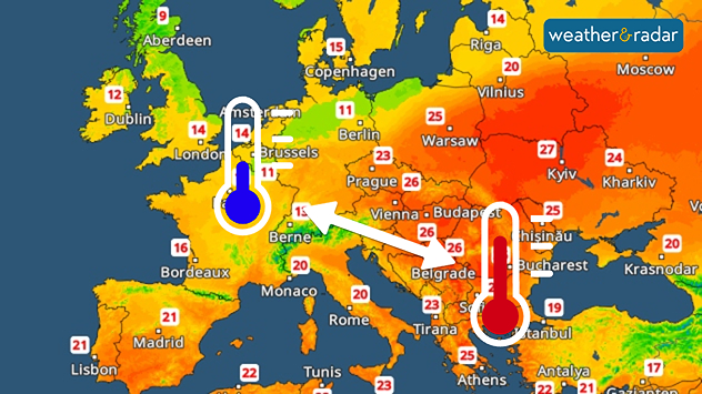
There are stark contrasts in the weather across Europe this week. From northern France and Germany to the Baltic coast of Poland, tomorrow’s temperatures will barely reach 10 degrees.

The TemperatureRadar shows significant temperature variations across Europe.

The situation is quite different in Southern and Eastern Europe, however: in many parts of the Balkans, it already feels like summer. In Vienna, Warsaw, and Budapest, too, the thermometer is reading over 25 degrees. High-pressure weather with plenty of sunshine is the dominant feature here.

Heavy rain from Paris to Berlin

Whilst the south-east is basking in sunshine, a broad band of rain is stretching from the French Atlantic coast to the Baltic region. By Thursday, widespread rainfall of 30 to 60 mm is expected there – and significantly more in some areas.

Northern Italy is also set to see heavy rain. Severe thunderstorms will bring similar amounts of rain, and this can quickly become too much – flooding and landslides cannot be ruled out in some areas.

Click here for the WeatherRadarread more

Kathrin Bogensperger
More on the topic
Cheshire Gap produces shower funnel. Local phenomenon. . . Wednesday, 9 September 2026
Weather map showing showers moving southeast from Liverpool toward Birmingham, driven by Cheshire Gap convergence across central England.
Wednesday, 9 September 2026

Local phenomenon

Cheshire Gap produces shower funnel
Hurricane Lowell threatens Hawaii. Gales and flash floods. . . Tuesday, 8 September 2026
WindRadar showing Hurricane Lowell north-west of Hawaii and its well-defined storm centre.
Tuesday, 8 September 2026

Gales and flash floods

Hurricane Lowell threatens Hawaii
Severe weather in southern Europe. Thunderstorms & heavy rain. . . Wednesday, 9 September 2026
On the left, dark storm clouds over a coastline. On the right, a weather map shows thunderstorms over the western Mediterranean, with warning symbols for tornadoes, storms and hail.
Wednesday, 9 September 2026

Thunderstorms & heavy rain

Severe weather in southern Europe
All weather news
This might also interest you
A frozen start to the weekend. Icy conditions. . . Friday, 13 February 2026
UK temperature map dated 14.02 showing widespread subzero values in blue shading, with readings such as −4 in Glasgow, −3 in Dublin, and −2 in London, alongside a blue thermometer icon.
Friday, 13 February 2026

Icy conditions

A frozen start to the weekend
New records for England and Wales. Broken again tomorrow?. . . Thursday, 25 June 2026
Temperature map of southwest Britain on 25.06 showing extreme heat across southern Wales and southwest England, with Bute Park in Cardiff highlighted at 34.2°C and Yeovilton at 36.4°C amid widespread deep red heat zones.
Thursday, 25 June 2026

Broken again tomorrow?

New records for England and Wales
Historic Storm Éowyn arrives. On this day.... . . Saturday, 24 January 2026
Split image showing a person in a yellow jacket struggling against strong winds and heavy rain on a street at night on the left, and an Irish wind forecast map on the right with red and purple shading, gusts up to 75 mph, and a wind warning icon, divided by a curved white line.
Saturday, 24 January 2026

On this day...

Historic Storm Éowyn arrives
All articles
Weather & Radar

Weather & Radar is also available on

Google Play StoreApp Store

Company

Contact us Privacy Policy Legal info Accessibility statement

Services

Uploader

Socials

facebooktwittertikToklinkList