Home
Weather London
WeatherRadar
RainfallRadar
TemperatureRadar
WindRadar
LightningRadar
Weather News
Editor's Pick
Discover the app
Weather widget
Contact us
Apps
Career
    Home / Editor's Pick /

    Severe weather risk in the Mediterranean: Turkey and Greece affected once again

10:34
27 October 2026

Turkey and Greece
Severe weather risk in the Mediterranean

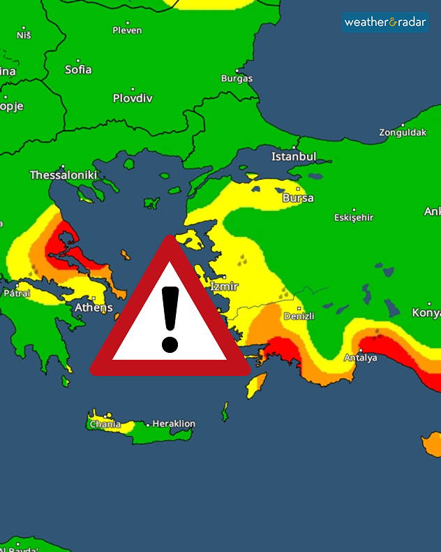
The risk of severe weather in the eastern Mediterranean is on the rise again. A powerful low-pressure system is set to move into the Aegean Sea tomorrow, bringing heavy thunderstorms and torrential rain to Greece and Turkey.

Popular holiday destinations such as the Turkish Riviera, Rhodes, Crete, and the region around Athens are particularly affected. By Thursday, 40 to 80 mm of rain is expected in some areas, with more than 200 mm possible locally. The risk of flooding, flash floods, and landslides is correspondingly high.

The weather warning map shows the risk of severe weather in parts of Greece and Turkey.

Depending on the ground conditions, the terrain and the drainage system, roads can quickly turn into raging torrents. It is also essential to keep well clear of streams and rivers. On top of that, there are strong to gale-force winds, which make the whole situation even more unpleasant.

WindRadar forecast for the Aegean Searead more
Weather & Radar editorial team

More on the topic

Overnight impacts as Austen hits. Power cuts, travel issues. . . Friday, 23 October 2026
Split image showing floodwater surging beneath a railway bridge at night and a wind map with low pressure over the English Channel and 60 mph near Brest.
Friday, 23 October 2026

Power cuts, travel issues

Overnight impacts as Austen hits
Shooting stars from the Orionids peak. Mixed visibility overnight. . . Wednesday, 21 October 2026
Split image showing a bright green meteor streaking across a starry night sky beside a UK weather map with rain over Scotland and southern England.
Wednesday, 21 October 2026

Mixed visibility overnight

Shooting stars from the Orionids peak
Storm Boelo named. Weekend impacts. . . Thursday, 22 October 2026
Split weather maps showing Storm Boelo northwest of Scotland, winds reaching 50 mph near Glasgow and Liverpool, and spiralling Atlantic rain bands.
Thursday, 22 October 2026

Weekend impacts

Storm Boelo named
All weather news

This might also interest you

A stormy week in the skies above. Your weather - Your shots. . . Sunday, 30 August 2026
Split image showing lightning branching beneath dark storm clouds above rooftops on the left and an orange-pink sunset over a calm sea on the right.
Sunday, 30 August 2026

Your weather - Your shots

A stormy week in the skies above
Storm Chandra makes impact. Severe gales & heavy rain. . . Tuesday, 27 January 2026
Split image showing strong winds over the UK on a forecast map and widespread rain and snow on a weather radar map.
Tuesday, 27 January 2026

Severe gales & heavy rain

Storm Chandra makes impact
New records for England and Wales. Broken again tomorrow?. . . Thursday, 25 June 2026
Temperature map of southwest Britain on 25.06 showing extreme heat across southern Wales and southwest England, with Bute Park in Cardiff highlighted at 34.2°C and Yeovilton at 36.4°C amid widespread deep red heat zones.
Thursday, 25 June 2026

Broken again tomorrow?

New records for England and Wales
All articles
Weather & Radar

Weather & Radar is also available on

Google Play StoreApp Store

Company

Contact us Privacy Policy Legal info Accessibility statement

Services

Uploader

Socials

facebooktwittertikToklinkList