Home
Weather London
WeatherRadar
RainfallRadar
TemperatureRadar
WindRadar
LightningRadar
Weather News
Editor's Pick
Discover the app
Weather widget
Contact us
Apps
Career
    Home / Editor's Pick /

    Severe weather in southern Europe: thunderstorms, hail and heavy rain on the way

11:14
9 September 2026

Thunderstorms & heavy rain
Severe weather in southern Europe

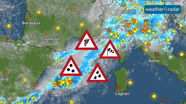
There’s a storm brewing in parts of southern Europe today. From this afternoon onwards, thunderstorms, some becoming severe, will be moving in from the western Mediterranean as far as northern Italy. Anyone currently travelling in these areas should be particularly careful:

  • Northern Italy
  • Mallorca, Menorca and Ibiza
  • Sardinia
  • Corsica

If you’re on holiday there or out and about, keep an eye on the sky and the WeatherRadar. First of all, so-called supercells form. These are particularly powerful thunderstorms that can bring large hailstones, torrential rain, heavy gusts of wind and, in isolated cases, even tornadoes.

WeatherRadar Forecast for today.

Later, the thunderstorms will merge to form larger thunderstorm systems. The main focus will then be on gales and, in some cases, prolonged heavy rain.

Heavy rainfall in Croatia

On Thursday and Friday, the focus of the severe weather will shift to the Adriatic. Particularly around Trieste and along the Croatian coast, 100 to 200 mm, and locally higher amounts, could fall within a short space of time.

This can cause streams and small rivers to rise very quickly. It’s best to avoid bodies of water during this time. By the weekend, the weather conditions will gradually ease off again.

Weather & Radar editorial team
More on the topic
Low delivers days of gusty conditions. Into the weekend. . . Thursday, 17 September 2026
Wind map showing low pressure near the Faroe Islands, with winds reaching 35 mph around Aberdeen and Dublin and stronger Atlantic winds west of the UK.
Thursday, 17 September 2026

Into the weekend

Low delivers days of gusty conditions
Huge low-pressure system off Iceland. Impacting the UK & Ireland. . . Wednesday, 16 September 2026
WeatherRadar showing a large low-pressure system over the North Atlantic between Greenland and Iceland.
Wednesday, 16 September 2026

Impacting the UK & Ireland

Huge low-pressure system off Iceland
Hurricane threat off the coast of Mexico. Storm and rain. . . Monday, 21 September 2026
Split image showing a powerful tropical system southwest of Acapulco on a wind map and palm trees bending sharply in strong winds.
Monday, 21 September 2026

Storm and rain

Hurricane threat off the coast of Mexico
All weather news
This might also interest you
Historic Storm Éowyn arrives. On this day.... . . Saturday, 24 January 2026
Split image showing a person in a yellow jacket struggling against strong winds and heavy rain on a street at night on the left, and an Irish wind forecast map on the right with red and purple shading, gusts up to 75 mph, and a wind warning icon, divided by a curved white line.
Saturday, 24 January 2026

On this day...

Historic Storm Éowyn arrives
Seasonal warmth between spring thunder. Your weather - Your shots. . . Sunday, 19 April 2026
Split image showing coastal sunset with layered lenticular clouds over rooftops and palm trees on the left, and a green valley with river and hills under soft daylight on the right.
Sunday, 19 April 2026

Your weather - Your shots

Seasonal warmth between spring thunder
Bright and warm conditions take hold. Spring-like outlook. . . Thursday, 23 April 2026
Split UK map showing warm temperatures up to 21 degrees in orange on the left and clear sunny conditions with temperatures from 12 to 18 degrees on the right, with sun icons across the country.
Thursday, 23 April 2026

Spring-like outlook

Bright and warm conditions take hold
All articles
Weather & Radar

Weather & Radar is also available on

Google Play StoreApp Store

Company

Contact us Privacy Policy Legal info Accessibility statement

Services

Uploader

Socials

facebooktwittertikToklinkList