Home
Weather London
WeatherRadar
RainfallRadar
TemperatureRadar
WindRadar
LightningRadar
Weather News
Editor's Pick
Discover the app
Weather widget
Contact us
Apps
Career
    Home / Editor's Pick /

    Severe weather in Italy: Flooding and heavy snowfall

10:00
2 April 2026

Severe weather in Italy
Flooding and heavy snowfall

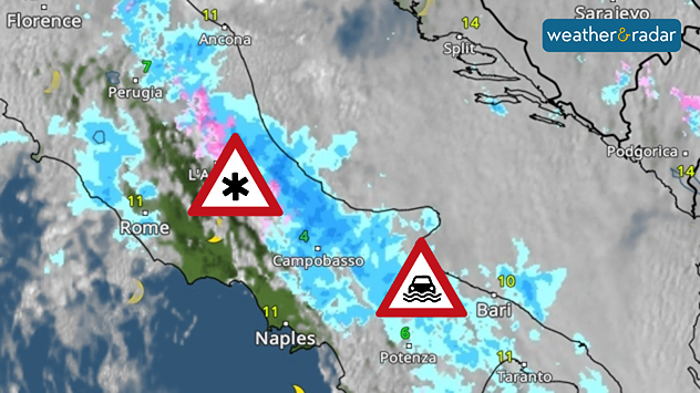
The powerful Mediterranean low-pressure system Erminio is causing severe weather in central and southern Italy.

Moist air masses are being forced up the slopes of the Apennines by strong easterly winds, leading to exceptionally high rainfall.

Stormy times in the MediterraneanWindRadar

As a result of the persistent rainfall, numerous rivers have burst their banks. Widespread flooding has occurred in regions ranging from Abruzzo to Apulia in the south-east of the country, amongst others.

More than 1.5 metres of fresh snow

At the same time, the higher reaches of the Apennines are seeing unusually heavy snowfall for this time of year. In some places, more than one and a half metres of fresh snow has already been recorded. The risk of avalanches is heightened due to the large amounts of fresh and drifted snow.

The WeatherRadar shows persistent rain over the north-eastern slopes of the mountains in central and southern Italy.

The impact is significant: road and rail services are being disrupted. This is leading to closures, delays and regional power cuts.

The situation remains tense for the time being: rain and snow are set to continue on Thursday. It is not until Good Friday that the low-pressure system will gradually move away and the precipitation ease off.

Michael Krucker
More on the topic
Solar eclipse on Wednesday. Save the date. . . Monday, 10 August 2026
People are watching a solar eclipse. The sun is already partially obscured. Next to it is the weather radar forecast for Wednesday, showing an almost cloudless sky.
Monday, 10 August 2026

Save the date

Solar eclipse on Wednesday
Poor harvest expected after drought. Rain remains scarce. . . Thursday, 6 August 2026
Split image showing an aerial view of drought-stricken parkland with dry yellow-brown grass surrounding a church on the left, and a temperature map of England and Wales on the right with temperatures reaching 30°C in southeast England.
Thursday, 6 August 2026

Rain remains scarce

Poor harvest expected after drought
The Perseids reach their peak. Shooting stars overhead. . . Tuesday, 11 August 2026
Shooting stars in the night sky
Tuesday, 11 August 2026

Shooting stars overhead

The Perseids reach their peak
All weather news
This might also interest you
New records for England and Wales. Broken again tomorrow?. . . Thursday, 25 June 2026
Temperature map of southwest Britain on 25.06 showing extreme heat across southern Wales and southwest England, with Bute Park in Cardiff highlighted at 34.2°C and Yeovilton at 36.4°C amid widespread deep red heat zones.
Thursday, 25 June 2026

Broken again tomorrow?

New records for England and Wales
Flooding, gales, and heavy snow. Storm Chandra. . . Tuesday, 27 January 2026
Split image showing aerial flooding in a town with muddy water covering roads on the left, and a rural road on the right blocked by heavy snowfall with vans stopped and a person walking in snow.
Tuesday, 27 January 2026

Storm Chandra

Flooding, gales, and heavy snow
Super Typhoon Bavi threatens Taiwan. Up to 1,000 mm of rain. . . Wednesday, 8 July 2026
The image shows an intense tropical cyclone over the western Pacific, east of Taiwan and the Philippines. The centre of the system is depicted as a light purple and white vortex with a clearly visible eye, surrounded by a ring of red and orange areas indicating the strongest wind speeds. A white arrow marks the typhoon’s predicted track towards the north-west, in the direction of Taiwan. To the west of the storm lie the Philippines, with the cities of Manila and Cebu; to the north of these lies Taiwan, with Taipei. Further west, the Chinese coast, including Hong Kong, and parts of Vietnam can be seen. The coloured wind map shows predominantly green areas outside the storm’s core, indicating significantly weaker winds. White streamlines illustrate the typhoon’s anti-clockwise circulation in the Northern Hemisphere. The highest wind speeds are concentrated around the eye of the cyclone.
Wednesday, 8 July 2026

Up to 1,000 mm of rain

Super Typhoon Bavi threatens Taiwan
All articles
Weather & Radar

Weather & Radar is also available on

Google Play StoreApp Store

Company

Contact us Privacy Policy Legal info Accessibility statement

Services

Uploader

Socials

facebooktwittertikToklinkList