Home
Weather London
WeatherRadar
RainfallRadar
TemperatureRadar
WindRadar
LightningRadar
Weather News
Editor's Pick
Discover the app
Weather widget
Contact us
Apps
Career
    Home / Editor's Pick /

    Severe weather in Italy: Flooding and heavy snowfall

10:00
2 April 2026

Severe weather in Italy
Flooding and heavy snowfall

The powerful Mediterranean low-pressure system Erminio is causing severe weather in central and southern Italy.

Moist air masses are being forced up the slopes of the Apennines by strong easterly winds, leading to exceptionally high rainfall.

Stormy times in the MediterraneanWindRadar

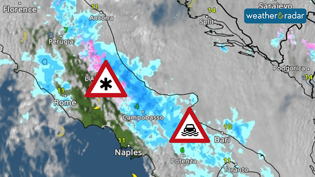
As a result of the persistent rainfall, numerous rivers have burst their banks. Widespread flooding has occurred in regions ranging from Abruzzo to Apulia in the south-east of the country, amongst others.

More than 1.5 metres of fresh snow

At the same time, the higher reaches of the Apennines are seeing unusually heavy snowfall for this time of year. In some places, more than one and a half metres of fresh snow has already been recorded. The risk of avalanches is heightened due to the large amounts of fresh and drifted snow.

The WeatherRadar shows persistent rain over the north-eastern slopes of the mountains in central and southern Italy.

The impact is significant: road and rail services are being disrupted. This is leading to closures, delays and regional power cuts.

The situation remains tense for the time being: rain and snow are set to continue on Thursday. It is not until Good Friday that the low-pressure system will gradually move away and the precipitation ease off.

Michael Krucker
More on the topic
Split image showing a nighttime lightning strike beneath storm clouds on the left and a lightning detection map with dense storm activity across central England on the right.
Wednesday, 27 May 2026

Trickier than you think

Why it's hard to pinpoint thunderstorms
Weather warning map of Wales and western Britain showing a yellow thunderstorm alert with lightning symbols, alongside a large warning triangle for lightning.
Wednesday, 27 May 2026

Wales & western England

Thunderstorm watch continues
Split image showing a bright rainbow above a residential street on the left and a dramatic ocean sunrise with glowing clouds and reflections on the sea on the right.
Sunday, 24 May 2026

Your weather - Your shots

From unsettled to warm and toasty
All weather news
This might also interest you
Split image showing a person in a yellow jacket struggling against strong winds and heavy rain on a street at night on the left, and an Irish wind forecast map on the right with red and purple shading, gusts up to 75 mph, and a wind warning icon, divided by a curved white line.
Saturday, 24 January 2026

On this day...

Historic Storm Éowyn arrives
Weather graphic showing rain and wind fields over the Canary Islands and a central warning symbol.
Friday, 12 December 2025

Storm and rain

Turbulent weather in the Canary Islands
Outline of Santa Claus with a yellow and white hat, "Ho-Ho-Ho" next to the outline above a Christmas tree.
Thursday, 25 December 2025

Merry Christmas!

Wishes from Weather & Radar
All articles
Weather & Radar

Weather & Radar is also available on

Google Play StoreApp Store

Company

Contact us Privacy Policy Legal info Accessibility statement

Services

Uploader

Socials

facebooktwittertikToklinkList