Home
Weather London
WeatherRadar
RainfallRadar
TemperatureRadar
WindRadar
LightningRadar
Weather News
Editor's Pick
Discover the app
Weather widget
Contact us
Apps
Career
    Home / Editor's Pick /

    Severe weather hits Mallorca and Italy

13:00
10 September 2026

Severe thunderstorms
Severe weather hits Mallorca and Italy

Severe storms are causing chaos across the Mediterranean. In Mallorca in particular, some areas have seen enormous amounts of rain.

A woman lost her life whilst attempting to cross a flooded road. In Escorca, on the island’s north-west coast, 89 mm of rain fell in a short space of time. This was accompanied by gale-force gusts.

Emergency services were called out more than 130 times in Mallorca, and over 40 flights had to be cancelled at Palma Airport. On the Spanish mainland, heavy thunderstorms brought torrential rain and gale-force winds to the areas around Barcelona and Valencia.

Severe thunderstorms also in northern Italy
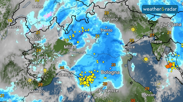
Heavy rain, hail, and gusts of wind have also caused damage in northern Italy. In Milan, parks remained closed as a precaution because of the risk of branches and trees falling.

Wednesday's WeatherRadar.

In addition, there were train cancellations on several railway lines in Lombardy due to fallen branches on the tracks.

Why the storms are so severe

One reason for the storms is the unusually warm Mediterranean. Following the extremely hot summer, water temperatures around Italy and south of France are still 4 to 6 degrees above the long-term average.

Off the Balearic Islands, too, the sea is unusually warm at just under 30°C, providing plenty of energy for the thunderstorms.

The severe weather conditions are continuing today. However, the focus of the storm is shifting from Italy across the Adriatic towards the Balkans.    

Weather & Radar editorial team
More on the topic
A generally gusty Thursday. Moderate but notable wind. . . Wednesday, 2 September 2026
Wind forecast showing widespread 25-30 mph winds across the UK and Ireland, including Glasgow, Dublin, Cork, Cardiff, and London, with a windsock symbol.
Wednesday, 2 September 2026

Moderate but notable wind

A generally gusty Thursday
Hurricane Lowell threatens Hawaii. Gales and flash floods. . . Tuesday, 8 September 2026
WindRadar showing Hurricane Lowell north-west of Hawaii and its well-defined storm centre.
Tuesday, 8 September 2026

Gales and flash floods

Hurricane Lowell threatens Hawaii
Autumn arrives with vivid colour. Your weather - Your shots. . . Sunday, 6 September 2026
Split image showing peach-lit textured clouds above silhouetted trees and golden cumulus clouds reflected in a calm canal lined with boats.
Sunday, 6 September 2026

Your weather - Your shots

Autumn arrives with vivid colour
All weather news
This might also interest you
Long-term trends need a pinch of salt. 40 °C in July?. . . Tuesday, 30 June 2026
Temperature radar of 2022 heatwave where the all-time temperature record in the UK was set. Warning symbol overlain.
Tuesday, 30 June 2026

40 °C in July?

Long-term trends need a pinch of salt
Flooding, gales, and heavy snow. Storm Chandra. . . Tuesday, 27 January 2026
Split image showing aerial flooding in a town with muddy water covering roads on the left, and a rural road on the right blocked by heavy snowfall with vans stopped and a person walking in snow.
Tuesday, 27 January 2026

Storm Chandra

Flooding, gales, and heavy snow
Super Typhoon Bavi threatens Taiwan. Up to 1,000 mm of rain. . . Wednesday, 8 July 2026
The image shows an intense tropical cyclone over the western Pacific, east of Taiwan and the Philippines. The centre of the system is depicted as a light purple and white vortex with a clearly visible eye, surrounded by a ring of red and orange areas indicating the strongest wind speeds. A white arrow marks the typhoon’s predicted track towards the north-west, in the direction of Taiwan. To the west of the storm lie the Philippines, with the cities of Manila and Cebu; to the north of these lies Taiwan, with Taipei. Further west, the Chinese coast, including Hong Kong, and parts of Vietnam can be seen. The coloured wind map shows predominantly green areas outside the storm’s core, indicating significantly weaker winds. White streamlines illustrate the typhoon’s anti-clockwise circulation in the Northern Hemisphere. The highest wind speeds are concentrated around the eye of the cyclone.
Wednesday, 8 July 2026

Up to 1,000 mm of rain

Super Typhoon Bavi threatens Taiwan
All articles
Weather & Radar

Weather & Radar is also available on

Google Play StoreApp Store

Company

Contact us Privacy Policy Legal info Accessibility statement

Services

Uploader

Socials

facebooktwittertikToklinkList