Home
Weather London
WeatherRadar
RainfallRadar
TemperatureRadar
WindRadar
LightningRadar
Weather News
Editor's Pick
Discover the app
Weather widget
Contact us
Apps
Career
    Home / Editor's Pick /

    Severe thunderstorms - Turbulent conditions in southern Europe

10:00
24 August 2026

Severe thunderstorms
Turbulent conditions in southern Europe

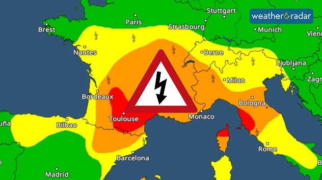
A rather precarious weather situation is developing from northern Spain through France to northern Italy.

A powerful thunderstorm front forms Monday afternoon from the Pyrenees to central France and will then move eastwards.

During the night leading into Tuesday, the thunderstorms will reach northern Italy and southern Switzerland before moving on towards the Adriatic.

Risk of severe weather from the Pyrenees to the Adriatic.

There is a significant risk of severe weather in the affected areas. The thunderstorms are bringing heavy rain, large hailstones, and gale-force gusts.

Roads may become flooded, trees may be uprooted, and in mountainous regions, landslides are even possible.

Follow the thunderstormsWeatherRadar
Weather & Radar editorial team

More on the topic

Preparing for the storms. What to do now. . . Thursday, 22 October 2026
Split image showing Storm Austen winds up to 65 mph near Brest and 55 mph near Plymouth, alongside fallen tree branches on a cordoned-off park path.
Thursday, 22 October 2026

What to do now

Preparing for the storms
Overnight impacts as Austen hits. Power cuts, travel issues. . . Friday, 23 October 2026
Split image showing floodwater surging beneath a railway bridge at night and a wind map with low pressure over the English Channel and 60 mph near Brest.
Friday, 23 October 2026

Power cuts, travel issues

Overnight impacts as Austen hits
Severe weather in the south of France. Holiday spots affected. . . Monday, 19 October 2026
A severe weather warning for heavy rain has been issued for the south of France.
Monday, 19 October 2026

Holiday spots affected

Severe weather in the south of France
All weather news

This might also interest you

Storm Chandra makes impact. Severe gales & heavy rain. . . Tuesday, 27 January 2026
Split image showing strong winds over the UK on a forecast map and widespread rain and snow on a weather radar map.
Tuesday, 27 January 2026

Severe gales & heavy rain

Storm Chandra makes impact
Historic Storm Éowyn arrives. On this day.... . . Saturday, 24 January 2026
Split image showing a person in a yellow jacket struggling against strong winds and heavy rain on a street at night on the left, and an Irish wind forecast map on the right with red and purple shading, gusts up to 75 mph, and a wind warning icon, divided by a curved white line.
Saturday, 24 January 2026

On this day...

Historic Storm Éowyn arrives
A stormy week in the skies above. Your weather - Your shots. . . Sunday, 30 August 2026
Split image showing lightning branching beneath dark storm clouds above rooftops on the left and an orange-pink sunset over a calm sea on the right.
Sunday, 30 August 2026

Your weather - Your shots

A stormy week in the skies above
All articles
Weather & Radar

Weather & Radar is also available on

Google Play StoreApp Store

Company

Contact us Privacy Policy Legal info Accessibility statement

Services

Uploader

Socials

facebooktwittertikToklinkList