Home
Weather London
WeatherRadar
RainfallRadar
TemperatureRadar
WindRadar
LightningRadar
Weather News
Editor's Pick
Discover the app
Weather widget
Contact us
Apps
Career
    Home / Editor's Pick /

    Severe thunderstorms - The monsoon has India firmly in its grip

12:00
9 July 2026

Severe thunderstorms
The monsoon has India firmly in its grip

The monsoon is in full swing over India, bringing around 80% of the country's annual rainfall within a few months, this is a vital time for the country.

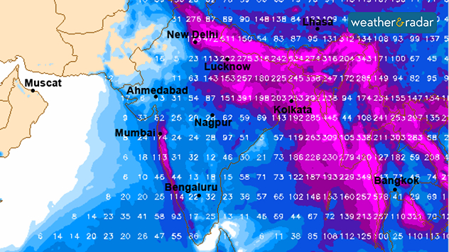
Thunderstorms can be seen daily on the WeatherRadar, these also trigger floods and landslides.

Did you know?

The word ‘monsoon’ comes from Arabic and translates as 'season’. 

The monsoon follows the same pattern every year. In early June, it first starts to rain in Kerala, the southernmost state. The rain then spreads north-westwards. In early July, it reaches the north-westernmost states – as it has done this year.

The forecast rainfall in India up to the end of next week

This year, the monsoon began a few days later than usual, following a very dry and hot June in India. The rain is therefore urgently needed. By the end of next week, rainfall is expected to exceed 300 mm in some areas.

Monsoon – The cause behind it all

The monsoon occurs because the land and sea heat up to different degrees depending on the season. This, in particular, causes the wind direction to change.

In summer, the wind in India shifts to the south-west, carrying moist air from the sea, bringing heavy rainfall far inland.

In winter, it is exactly the opposite: the wind blows mainly from the north to north-east, from the dry mainland, so there is hardly any rain.

Weather & Radar editorial team
More on the topic
Hottest summer on record for Ireland. Beating 2025's record. . . Thursday, 3 September 2026
Temperature map of Ireland showing 29°C in Dublin, 26°C in Cork, 24°C in Belfast, and 23°C in Galway, with a red thermometer icon.
Thursday, 3 September 2026

Beating 2025's record

Hottest summer on record for Ireland
A generally gusty Thursday. Moderate but notable wind. . . Wednesday, 2 September 2026
Wind forecast showing widespread 25-30 mph winds across the UK and Ireland, including Glasgow, Dublin, Cork, Cardiff, and London, with a windsock symbol.
Wednesday, 2 September 2026

Moderate but notable wind

A generally gusty Thursday
Severe weather in southern Europe. Thunderstorms & heavy rain. . . Wednesday, 9 September 2026
On the left, dark storm clouds over a coastline. On the right, a weather map shows thunderstorms over the western Mediterranean, with warning symbols for tornadoes, storms and hail.
Wednesday, 9 September 2026

Thunderstorms & heavy rain

Severe weather in southern Europe
All weather news
This might also interest you
Storm Chandra makes impact. Severe gales & heavy rain. . . Tuesday, 27 January 2026
Split image showing strong winds over the UK on a forecast map and widespread rain and snow on a weather radar map.
Tuesday, 27 January 2026

Severe gales & heavy rain

Storm Chandra makes impact
Flooding, gales, and heavy snow. Storm Chandra. . . Tuesday, 27 January 2026
Split image showing aerial flooding in a town with muddy water covering roads on the left, and a rural road on the right blocked by heavy snowfall with vans stopped and a person walking in snow.
Tuesday, 27 January 2026

Storm Chandra

Flooding, gales, and heavy snow
New records for England and Wales. Broken again tomorrow?. . . Thursday, 25 June 2026
Temperature map of southwest Britain on 25.06 showing extreme heat across southern Wales and southwest England, with Bute Park in Cardiff highlighted at 34.2°C and Yeovilton at 36.4°C amid widespread deep red heat zones.
Thursday, 25 June 2026

Broken again tomorrow?

New records for England and Wales
All articles
Weather & Radar

Weather & Radar is also available on

Google Play StoreApp Store

Company

Contact us Privacy Policy Legal info Accessibility statement

Services

Uploader

Socials

facebooktwittertikToklinkList