Home
Weather London
WeatherRadar
RainfallRadar
TemperatureRadar
WindRadar
LightningRadar
Weather News
Editor's Pick
Discover the app
Weather widget
Contact us
Apps
Career
    Home / Editor's Pick /

    Severe overnight gales - Storm Dave makes impact

13:28
4 April 2026

Severe overnight gales
Storm Dave makes impact

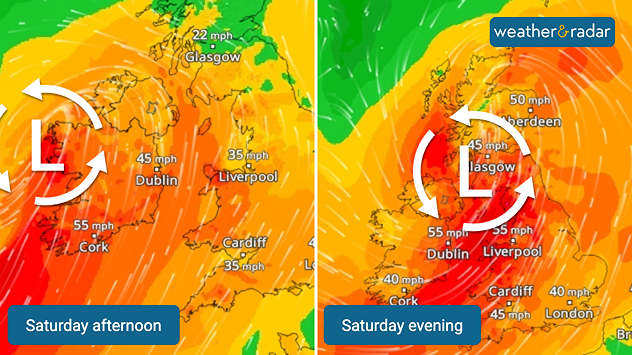
Side-by-side wind maps of the UK and Ireland for Saturday afternoon and evening, showing a deepening low-pressure system with orange-red wind zones and gusts up to 55 mph moving east.
Storm Dave continues to deliver strong gales from Saturday into Sunday.

Storm Dave is being felt Saturday afternoon as it continues to move northeast overnight into Sunday.

Amber warnings have been issued for northern England and Wales, active from 07:00 pm Saturday until the early hours.

Isolated gusts of up to 80 mph are now expected in these regions, with 60 - 70 mph widely within the warning areas. Dave first impacts Ireland, where as of Saturday afternoon gusts of up to 60 mph (90 km/h) were felt in the west and south.

It is not until the evening, where the amber warnings come into force, that stronger gales reach the UK.

Further yellow warnings for wind cover the whole of Ireland, Northern Ireland, Scotland and other areas of England and Wales.

These are joined by a snow warning in western Scotland, where the strong winds can create blizzard conditions. Storm Dave continues to move east Sunday, heading towards Denmark by Easter Monday.

Track Storm Dave in real-timeWindRadar
Ryan Hathaway
More on the topic
v
Thursday, 28 May 2026

Gusts exceeding 124 mph

Typhoon risk in the Western Pacific
On the left is the temperature radar, showing high temperatures across Western Europe. On the right is the weather radar, showing a high-pressure system.
Tuesday, 26 May 2026

Summer weather in spring

Heatwave sets new records in Europe too
Weather warning map of Wales and western Britain showing a yellow thunderstorm alert with lightning symbols, alongside a large warning triangle for lightning.
Wednesday, 27 May 2026

Wales & western England

Thunderstorm watch continues
All weather news
This might also interest you
Outline of Santa Claus with a yellow and white hat, "Ho-Ho-Ho" next to the outline above a Christmas tree.
Thursday, 25 December 2025

Merry Christmas!

Wishes from Weather & Radar
Split image showing aerial flooding in a town with muddy water covering roads on the left, and a rural road on the right blocked by heavy snowfall with vans stopped and a person walking in snow.
Tuesday, 27 January 2026

Storm Chandra

Flooding, gales, and heavy snow
Split UK map showing warm temperatures up to 21 degrees in orange on the left and clear sunny conditions with temperatures from 12 to 18 degrees on the right, with sun icons across the country.
Thursday, 23 April 2026

Spring-like outlook

Bright and warm conditions take hold
All articles
Weather & Radar

Weather & Radar is also available on

Google Play StoreApp Store

Company

Contact us Privacy Policy Legal info Accessibility statement

Services

Uploader

Socials

facebooktwittertikToklinkList