Home
Weather London
WeatherRadar
RainfallRadar
TemperatureRadar
WindRadar
LightningRadar
Weather News
Editor's Pick
Discover the app
Weather widget
Contact us
Apps
Career
    Home / Weather News /

    Severe gales & heavy rain: Storm Chandra arrives Tuesday

11:04
27 January 2026

Severe gales & heavy rain
Storm Chandra makes impact

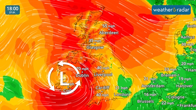
Severe gales and widespread strong winds for Tuesday.

Storm Chandra, the third named storm of the current season, has been named for impact on Tuesday.

The system will bring severe gales with gusts of up to 75 mph in coastal areas of Ireland and Northern Ireland. Strong, blustery conditions also spread more widely.

Rainfall accumulation levels reached 100 mm at White Barrow, South Dartmoor overnight while widespread flood warnings have been issued.

In Ottery Saint Mary, Devon, the River Otter reached a record high as rain fell in the night, but is now dropping.

Third named storm

Chandra follows storms Amy and Bram in October and December respectively. Despite this, the UK and Ireland have also felt the impacts from Benjamin, Claudia, and Goretti in recent months, all named by European meteorological agencies.

Flights and ferries were also cancelled across the UK due to the gales.

The stormy conditions will be relatively short-lived, with conditions mostly calming again by Wednesday.

Follow Chandra's progressWindRadar
Ryan Hathaway

More on the topic

Storm Boelo named. Weekend impacts. . . Thursday, 22 October 2026
Split weather maps showing Storm Boelo northwest of Scotland, winds reaching 50 mph near Glasgow and Liverpool, and spiralling Atlantic rain bands.
Thursday, 22 October 2026

Weekend impacts

Storm Boelo named
Winds grow and rain spreads Wednesday. Prelude to Austen. . . Wednesday, 21 October 2026
Split weather map showing strong winds up to 40 mph across southern Britain and blue rain bands over Scotland, Ireland and England, with warning symbols.
Wednesday, 21 October 2026

Prelude to Austen

Winds grow and rain spreads Wednesday
Shooting stars from the Orionids peak. Mixed visibility overnight. . . Wednesday, 21 October 2026
Split image showing a bright green meteor streaking across a starry night sky beside a UK weather map with rain over Scotland and southern England.
Wednesday, 21 October 2026

Mixed visibility overnight

Shooting stars from the Orionids peak
All weather news

This might also interest you

Seasonal warmth between spring thunder. Your weather - Your shots. . . Sunday, 19 April 2026
Split image showing coastal sunset with layered lenticular clouds over rooftops and palm trees on the left, and a green valley with river and hills under soft daylight on the right.
Sunday, 19 April 2026

Your weather - Your shots

Seasonal warmth between spring thunder
New records for England and Wales. Broken again tomorrow?. . . Thursday, 25 June 2026
Temperature map of southwest Britain on 25.06 showing extreme heat across southern Wales and southwest England, with Bute Park in Cardiff highlighted at 34.2°C and Yeovilton at 36.4°C amid widespread deep red heat zones.
Thursday, 25 June 2026

Broken again tomorrow?

New records for England and Wales
A stormy week in the skies above. Your weather - Your shots. . . Sunday, 30 August 2026
Split image showing lightning branching beneath dark storm clouds above rooftops on the left and an orange-pink sunset over a calm sea on the right.
Sunday, 30 August 2026

Your weather - Your shots

A stormy week in the skies above
All articles
Weather & Radar

Weather & Radar is also available on

Google Play StoreApp Store

Company

Contact us Privacy Policy Legal info Accessibility statement

Services

Uploader

Socials

facebooktwittertikToklinkList