Home
Weather London
WeatherRadar
RainfallRadar
TemperatureRadar
WindRadar
LightningRadar
Weather News
Editor's Pick
Discover the app
Weather widget
Contact us
Apps
Career
    Home / Editor's Pick /

    Severe damage along the Adriatic coast - Huge hailstones and storms

12:00
22 July 2026

Huge hail and storms
Severe damage along the Adriatic coast

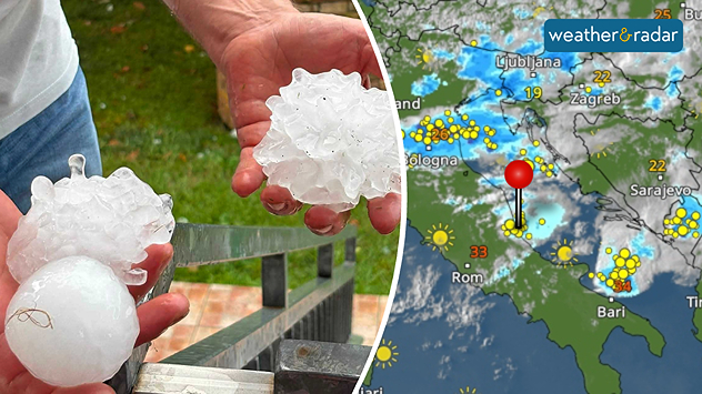
Severe thunderstorms raged across the Adriatic region on Tuesday. Italy, Croatia, Serbia, Bosnia and Herzegovina, and Montenegro were particularly hard hit.

In some places, hailstones were at least the size of a fist, measuring between five and over ten centimetres in diameter fell causing enormous damage.

In Roseto degli Abruzzi, Italy, hailstones over ten centimetres in size are pounding down from the sky.

In addition, the storms brought torrential rain and severe gusts of wind. There are even reports of possible tornadoes. The damage in the Balkans and in Italy is extensive. Roads have been flooded, farmland destroyed, and trees have been uprooted.

The situation has now stabilised across the regions, as our WeatherRadar shows. The severe thunderstorms have moved on with severe weather expected mainly around the Black Sea today.

Severe thunderstorms on the Black SeaWeatherRadar

Kathrin Bogensperger

More on the topic

Autumn is the season for fog. High pressure, but no sun. . . Thursday, 5 November 2026
A split-screen image showing the weather radar for Europe and a mountain landscape. On the right, snow-capped peaks rise above a thick blanket of fog against a blue sky.
Thursday, 5 November 2026

High pressure, but no sun

Autumn is the season for fog
Further fog disruption expected. Growing dense overnight. . . Monday, 9 November 2026
Weather map showing widespread fog across the English Midlands, with a red fog warning symbol near Nottingham and temperatures of 4–6°C.
Monday, 9 November 2026

Growing dense overnight

Further fog disruption expected
Conditions combine to reduce air quality. Light winds and fireworks. . . Tuesday, 10 November 2026
Split image showing a UK wind map with 25 mph near Cardiff and 19 mph near London, beside colourful fireworks above illuminated waterfront buildings.
Tuesday, 10 November 2026

Light winds and fireworks

Conditions combine to reduce air quality
All weather news

This might also interest you

Flooding, gales, and heavy snow. Storm Chandra. . . Tuesday, 27 January 2026
Split image showing aerial flooding in a town with muddy water covering roads on the left, and a rural road on the right blocked by heavy snowfall with vans stopped and a person walking in snow.
Tuesday, 27 January 2026

Storm Chandra

Flooding, gales, and heavy snow
Bright and warm conditions take hold. Spring-like outlook. . . Thursday, 23 April 2026
Split UK map showing warm temperatures up to 21 degrees in orange on the left and clear sunny conditions with temperatures from 12 to 18 degrees on the right, with sun icons across the country.
Thursday, 23 April 2026

Spring-like outlook

Bright and warm conditions take hold
New records for England and Wales. Broken again tomorrow?. . . Thursday, 25 June 2026
Temperature map of southwest Britain on 25.06 showing extreme heat across southern Wales and southwest England, with Bute Park in Cardiff highlighted at 34.2°C and Yeovilton at 36.4°C amid widespread deep red heat zones.
Thursday, 25 June 2026

Broken again tomorrow?

New records for England and Wales
All articles
Weather & Radar

Weather & Radar is also available on

Google Play StoreApp Store

Company

Contact us Privacy Policy Legal info Accessibility statement

Services

Uploader

Socials

facebooktwittertikToklinkList