Home
Weather London
WeatherRadar
RainfallRadar
TemperatureRadar
WindRadar
LightningRadar
Weather News
Editor's Pick
Discover the app
Weather widget
Contact us
Apps
Career
    Home / Editor's Pick /

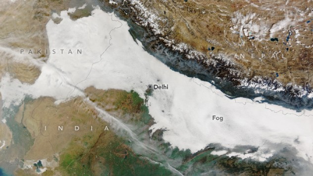
    Seen on the WeatherRadar: Thick fog flows from Pakistan into India

08:00
20 January 2024

Seen on the WeatherRadar
Thick fog flows from Pakistan into India

Satellite image of fog
Thick fog seen spreading from Pakistan into India from NASA's Terra satellite. - © NASA

Thick fog has spread across the Indo-Gangetic Plain this week, stretching from Pakistan, across India, into Bangladesh.

As a result of the fog, flights and trains have seen delays and cancellations in some places due to lack of visibility.

The fog was captured from above by NASA satellite Terra, and was also visible on the WeatherRadar on January 15 as the satellite image was captured.

Much of the fog is a form known as radiation fog which develops overnight as ground temperatures fall and moisture in the air grows.

Combine these with slower winds and the dense form of fog is created.

Learn more about how different forms of fog develop with our Weather Explained video:

Research from the University of East Anglia and the University of Leeds suggests that fog across the Indo-Gangetic Plain is becoming more frequent and more intense.

The study looked at fog outbreaks from 2000 to 2020 and suggests that rising aerosol pollution from urbanisation is a likely cause.

Alongside the fog, temperatures across parts of India are falling in a cold wave. This is spreading across the state of Madhya Pradesh with temperatures dropping 4 to 7°C below normal.

Mountain waves seen on the WeatherRadarread more
Ryan Hathaway
More on the topic
Late season views as summer rolls on. Your weather - Your shots. . . Sunday, 9 August 2026
Split image showing a horseback ride along a green hillside trail beneath blue skies on the left and a small sailboat on a calm coastal bay under broken clouds on the right.
Sunday, 9 August 2026

Your weather - Your shots

Late season views as summer rolls on
Hottest day of the year so far. Close to August record. . . Thursday, 13 August 2026
Temperature map of London showing 38.1°C at Kew Gardens, with surrounding readings of 35–36°C and deep red shading indicating extreme heat.
Thursday, 13 August 2026

Close to August record

Hottest day of the year so far
Europe's summer set to to break records. Extreme heat and drought. . . Tuesday, 11 August 2026
Split image showing a European heat map with temperatures reaching 39°C in France and Spain on the left, and a severely depleted river with exposed sandy banks beneath a bridge on the right.
Tuesday, 11 August 2026

Extreme heat and drought

Europe's summer set to to break records
All weather news
This might also interest you
Long-term trends need a pinch of salt. 40 °C in July?. . . Tuesday, 30 June 2026
Temperature radar of 2022 heatwave where the all-time temperature record in the UK was set. Warning symbol overlain.
Tuesday, 30 June 2026

40 °C in July?

Long-term trends need a pinch of salt
Turbulent weather in the Canary Islands. Storm and rain. . . Friday, 12 December 2025
Weather graphic showing rain and wind fields over the Canary Islands and a central warning symbol.
Friday, 12 December 2025

Storm and rain

Turbulent weather in the Canary Islands
Bright and warm conditions take hold. Spring-like outlook. . . Thursday, 23 April 2026
Split UK map showing warm temperatures up to 21 degrees in orange on the left and clear sunny conditions with temperatures from 12 to 18 degrees on the right, with sun icons across the country.
Thursday, 23 April 2026

Spring-like outlook

Bright and warm conditions take hold
All articles
Weather & Radar

Weather & Radar is also available on

Google Play StoreApp Store

Company

Contact us Privacy Policy Legal info Accessibility statement

Services

Uploader

Socials

facebooktwittertikToklinkList