Home
Weather London
WeatherRadar
RainfallRadar
TemperatureRadar
WindRadar
LightningRadar
Weather News
Editor's Pick
Discover the app
Weather widget
Contact us
Apps
Career
    Home / Editor's Pick /

    Sea fog: Sharp boundary along California

13:00
17 July 2025

Coastal phenomenon
Sea fog: Sharp boundary along Cali

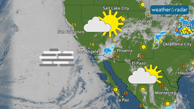
WeatherRadar: The sharp boundary between sea fog and clear weather along the Californian coast is clearly visible.

It almost feels like autumn: thick, damp fog hangs over the Pacific Ocean off the west coast of California, enveloping San Francisco.

Just a few kilometres inland, bright sunshine promises a perfect summer's day.

The phenomenon occurs on the US west coast when warm air passes over areas of water cooled by cold ocean currents. This causes the air in a layer a few dozen metres thick to cool down and excess moisture to condense into fog.

This coastal fog can linger for long periods during the day, and temperatures remain low: while it rarely exceeds 20 degrees in the fog, even in summer, inland temperatures often rise well above 30 degrees.

Weather & Radar editorial team

More on the topic

Warnings live across the UK and Ireland. How do they work?. . . Tuesday, 20 October 2026
Weather warning map showing yellow and orange wind alerts across Ireland and England, with red level 3 areas in southwest England and a windsock symbol.
Tuesday, 20 October 2026

How do they work?

Warnings live across the UK and Ireland
Storm Austen approaches. What to expect tonight. . . Thursday, 22 October 2026
Split image showing a wind map with 65 mph near Brest and a swirling storm south of England, beside a man wearing glasses and holding a microphone.
Thursday, 22 October 2026

What to expect tonight

Storm Austen approaches
Overnight impacts as Austen hits. Power cuts, travel issues. . . Friday, 23 October 2026
Split image showing floodwater surging beneath a railway bridge at night and a wind map with low pressure over the English Channel and 60 mph near Brest.
Friday, 23 October 2026

Power cuts, travel issues

Overnight impacts as Austen hits
All weather news

This might also interest you

Historic Storm Éowyn arrives. On this day.... . . Saturday, 24 January 2026
Split image showing a person in a yellow jacket struggling against strong winds and heavy rain on a street at night on the left, and an Irish wind forecast map on the right with red and purple shading, gusts up to 75 mph, and a wind warning icon, divided by a curved white line.
Saturday, 24 January 2026

On this day...

Historic Storm Éowyn arrives
A stormy week in the skies above. Your weather - Your shots. . . Sunday, 30 August 2026
Split image showing lightning branching beneath dark storm clouds above rooftops on the left and an orange-pink sunset over a calm sea on the right.
Sunday, 30 August 2026

Your weather - Your shots

A stormy week in the skies above
New records for England and Wales. Broken again tomorrow?. . . Thursday, 25 June 2026
Temperature map of southwest Britain on 25.06 showing extreme heat across southern Wales and southwest England, with Bute Park in Cardiff highlighted at 34.2°C and Yeovilton at 36.4°C amid widespread deep red heat zones.
Thursday, 25 June 2026

Broken again tomorrow?

New records for England and Wales
All articles
Weather & Radar

Weather & Radar is also available on

Google Play StoreApp Store

Company

Contact us Privacy Policy Legal info Accessibility statement

Services

Uploader

Socials

facebooktwittertikToklinkList