Home
Weather London
WeatherRadar
RainfallRadar
TemperatureRadar
WindRadar
LightningRadar
Weather News
Editor's Pick
Discover the app
Weather widget
Contact us
Apps
Career
    Home / Editor's Pick /

    Sea fog rolls into Pembrokeshire - unique summer scene

09:00
14 July 2026

Unique summer scene
Sea fog rolls into Pembrokeshire

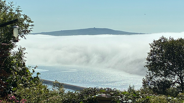
Sea fog rolls into Fishguard, Pembrokeshire. - © Susan Busby

Waves of sea fog roll clouds pushed into Pembrokeshire in recent days, creating a unique summer scene.

Pictured from Fishguard, sea fog commonly forms when a warm air mass is cooled and moistened from below while moving over the sea.

While seas around the UK are currently much warmer than average, the difference in temperature is still strong enough to create sea fog.

Local winds and turbulence around the coast can then help create these unusual shapes as the sea fog moves towards the coast or away from it.

In July, the Celtic Sea often remains relatively cool compared to summer air and is particularly susceptible to moist southwesterly or westerly air from the Atlantic creating sea fog, also known as haar in the UK.

If you've seen a similar sight, or something equally as interesting, send it in to the uploader!

Ryan Hathaway

More on the topic

First major storm of the season. Storm Austen named. . . Tuesday, 20 October 2026
On the left, WindRadar shows a storm system over the UK with strong winds. On the right, high waves are crashing against a sea wall. A warning symbol indicates a storm.
Tuesday, 20 October 2026

Storm Austen named

First major storm of the season
Severe flooding in the south of France. Roads become rivers. . . Wednesday, 21 October 2026
Weather radar shows heavy rainfall over southern France, northern Italy, Corsica and Sardinia. A warning symbol indicates a risk of flooding.
Wednesday, 21 October 2026

Roads become rivers

Severe flooding in the south of France
Warnings live across the UK and Ireland. How do they work?. . . Tuesday, 20 October 2026
Weather warning map showing yellow and orange wind alerts across Ireland and England, with red level 3 areas in southwest England and a windsock symbol.
Tuesday, 20 October 2026

How do they work?

Warnings live across the UK and Ireland
All weather news

This might also interest you

Long-term trends need a pinch of salt. 40 °C in July?. . . Tuesday, 30 June 2026
Temperature radar of 2022 heatwave where the all-time temperature record in the UK was set. Warning symbol overlain.
Tuesday, 30 June 2026

40 °C in July?

Long-term trends need a pinch of salt
Flooding, gales, and heavy snow. Storm Chandra. . . Tuesday, 27 January 2026
Split image showing aerial flooding in a town with muddy water covering roads on the left, and a rural road on the right blocked by heavy snowfall with vans stopped and a person walking in snow.
Tuesday, 27 January 2026

Storm Chandra

Flooding, gales, and heavy snow
Storm Chandra makes impact. Severe gales & heavy rain. . . Tuesday, 27 January 2026
Split image showing strong winds over the UK on a forecast map and widespread rain and snow on a weather radar map.
Tuesday, 27 January 2026

Severe gales & heavy rain

Storm Chandra makes impact
All articles
Weather & Radar

Weather & Radar is also available on

Google Play StoreApp Store

Company

Contact us Privacy Policy Legal info Accessibility statement

Services

Uploader

Socials

facebooktwittertikToklinkList