Home
Weather London
WeatherRadar
RainfallRadar
TemperatureRadar
WindRadar
LightningRadar
Weather News
Editor's Pick
Discover the app
Weather widget
Contact us
Apps
Career
    Home / Editor's Pick /

    Sahara dust over south-western Europe – blood rain is possible

08:36
2 March 2026

Blood rain is possible
Sahara dust over south-western Europe

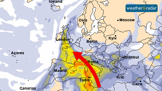
A low-pressure system over south-western Europe will stir up a lot of Saharan dust in the coming days.

The system will transport desert sand with southerly winds across the western Mediterranean towards the Iberian Peninsula and France.

Towards the weekend, the dust streaks will also reach parts of Central Europe.

The forecast maps for Thursday show large parts of south-western Europe covered by a thick veil of dust.

The dust whirled up to a height of several kilometres, clouding the clear sky with a milky veil. Where the dust quantities are large, it can even appear ochre-coloured, especially where high cloud fields are passing by.

Rain turns into "blood rain"

When precipitation is added to the mix, "blood rain" also becomes an issue. This will be particularly the case over the Iberian Peninsula and parts of France: the sand will be washed out of the air by rain and settle on cars, for example, as a yellowish-reddish "layer of dirt".

Towards the weekend, the dust trails in the atmosphere are likely to reach Central Europe as well.

Although they will no longer be as dense as in Spain and France, they will probably be enough to cause a milky haze in the sky here too.

Jürgen Vollmer
Ryan Hathaway
More on the topic
Drought for North Wales and Upper Severn. 2% of average rainfall. . . Thursday, 23 July 2026
Split image showing a July rainfall anomaly map of Europe on the left with below-average rainfall across the UK, Ireland, and much of western and central Europe, and an active moorland wildfire on the right producing flames and thick smoke near homes.
Thursday, 23 July 2026

2% of average rainfall

Drought for North Wales and Upper Severn
Catastrophic forest fires in Europe. Thousands evacuated. . . Monday, 27 July 2026
A composite image showing a temperature map of south-western Europe and a drone shot of a forest fire near Cap Ferret. A warning symbol featuring a flame indicates the increased risk of forest fires.
Monday, 27 July 2026

Thousands evacuated

Catastrophic forest fires in Europe
Rain returns to end dry spell in places. Jet stream delivery. . . Thursday, 23 July 2026
Split weather graphic showing widespread showers across the UK and Ireland on the left, and a wind forecast map on the right with a windsock icon and gusts of 25 to 35 mph, highlighting breezy conditions across the two countries.
Thursday, 23 July 2026

Jet stream delivery

Rain returns to end dry spell in places
All weather news
This might also interest you
Flooding, gales, and heavy snow. Storm Chandra. . . Tuesday, 27 January 2026
Split image showing aerial flooding in a town with muddy water covering roads on the left, and a rural road on the right blocked by heavy snowfall with vans stopped and a person walking in snow.
Tuesday, 27 January 2026

Storm Chandra

Flooding, gales, and heavy snow
Turbulent weather in the Canary Islands. Storm and rain. . . Friday, 12 December 2025
Weather graphic showing rain and wind fields over the Canary Islands and a central warning symbol.
Friday, 12 December 2025

Storm and rain

Turbulent weather in the Canary Islands
New records for England and Wales. Broken again tomorrow?. . . Thursday, 25 June 2026
Temperature map of southwest Britain on 25.06 showing extreme heat across southern Wales and southwest England, with Bute Park in Cardiff highlighted at 34.2°C and Yeovilton at 36.4°C amid widespread deep red heat zones.
Thursday, 25 June 2026

Broken again tomorrow?

New records for England and Wales
All articles
Weather & Radar

Weather & Radar is also available on

Google Play StoreApp Store

Company

Contact us Privacy Policy Legal info Accessibility statement

Services

Uploader

Socials

facebooktwittertikToklinkList