Home
Weather London
WeatherRadar
RainfallRadar
TemperatureRadar
WindRadar
LightningRadar
Weather News
Editor's Pick
Discover the app
Weather widget
Contact us
Apps
Career
    Home / Editor's Pick /

    Revealed by satellite: Severe floods as River Severn peaks

11:30
5 January 2024

Revealed by satellite
Severe floods as River Severn peaks

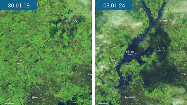
Comparison of flooding
Satellite imagery shows the extent of flooding in the West Midlands this week in the aftermath of Storm Henk. - © NASA

The full scope of flooding in the UK this week has been displayed by new satellite images showing severe floods along the River Severn.

Released by NASA, the imagery highlights vast flooding in rural parts of the West Midlands after the arrival of Storm Henk kickstarted a week of heavy rain.

In some places, the Severn breached its river banks in more populated areas. Including the town of Ironbridge, where flood defences helped avoid the worst-case situation but still saw properties flooded as the river reached a height of 6.35 m early Friday morning.

Flooded street
Flooded cricket ground
flooded pub
Flood defences
1/4
Floodwater runs through Ratcliffe-on-Trent, Nottinghamshire after a major incident was declared. - © picture alliance

In Nottinghamshire, a 'major incident' was declared on Thursday due to the River Trent reaching close to a record-high.

The village of Ratcliffe-on-Trent saw residents of a static caravan park evacuated on Thursday after flood water rendered some mobile homes inaccessible.

Property flooding

The Environment Agency say that more than 1,000 properties in England have been flooded this week.

Evacuations also took place in Hackney Wick, East London, where around 50 people were forced to take action after canal water surged into residential streets.

As of Friday morning, more than 270 flood warnings, indicating flooding is expected, remain in force across England.

Although rainfall has eased, saturated soil in many southern areas means that it only takes a little rainfall for surface flooding to develop while rivers remain at elevated levels.

Both South Western Railway and Great Western Railway report disruption to their rail networks, while surface flooding is also impacting road traffic.

To see what the weather has in store for you, check the WeatherRadar at any time.

Tips: Preparing for a floodread more
Ryan Hathaway
More on the topic
Forest fires are getting out of control. Spain and France. . . Saturday, 25 July 2026
A split-screen image featuring a photograph and a weather map. On the left, thick, dark-grey smoke rises from several fire sites in a wooded coastal area; a calm stretch of water can be seen in the foreground. On the right, a weather map shows south-western France and northern Spain. A red arrow points from the Atlantic towards the French Atlantic coast, symbolising an onshore wind. Sunny weather is forecast for Bordeaux at around 20 degrees, and Bilbao is also expected to be sunny at around 27 degrees. A large warning sign with a flame symbol indicates an increased risk of forest fires.
Saturday, 25 July 2026

Spain and France

Forest fires are getting out of control
Icy spells in the Southern Hemisphere. Snow in the Andes. . . Tuesday, 28 July 2026
A composite image showing a temperature radar map of South America and a snow-covered town in Chile. The winter cold is bringing heavy snowfall to the Andes and, in some areas, snow down to lower altitudes.
Tuesday, 28 July 2026

Snow in the Andes

Icy spells in the Southern Hemisphere
Fourth heatwave of the year. Peaking Wednesday. . . Tuesday, 28 July 2026
Temperature map of England and Wales on Wednesday 29.07 showing widespread hot conditions, with temperatures reaching 33°C near Cambridge, 32°C around London, Norwich, and Southend-on-Sea, and a large heat warning symbol highlighting elevated heat risk.
Tuesday, 28 July 2026

Peaking Wednesday

Fourth heatwave of the year
All weather news
This might also interest you
Super Typhoon Bavi threatens Taiwan. Up to 1,000 mm of rain. . . Wednesday, 8 July 2026
The image shows an intense tropical cyclone over the western Pacific, east of Taiwan and the Philippines. The centre of the system is depicted as a light purple and white vortex with a clearly visible eye, surrounded by a ring of red and orange areas indicating the strongest wind speeds. A white arrow marks the typhoon’s predicted track towards the north-west, in the direction of Taiwan. To the west of the storm lie the Philippines, with the cities of Manila and Cebu; to the north of these lies Taiwan, with Taipei. Further west, the Chinese coast, including Hong Kong, and parts of Vietnam can be seen. The coloured wind map shows predominantly green areas outside the storm’s core, indicating significantly weaker winds. White streamlines illustrate the typhoon’s anti-clockwise circulation in the Northern Hemisphere. The highest wind speeds are concentrated around the eye of the cyclone.
Wednesday, 8 July 2026

Up to 1,000 mm of rain

Super Typhoon Bavi threatens Taiwan
Historic Storm Éowyn arrives. On this day.... . . Saturday, 24 January 2026
Split image showing a person in a yellow jacket struggling against strong winds and heavy rain on a street at night on the left, and an Irish wind forecast map on the right with red and purple shading, gusts up to 75 mph, and a wind warning icon, divided by a curved white line.
Saturday, 24 January 2026

On this day...

Historic Storm Éowyn arrives
Long-term trends need a pinch of salt. 40 °C in July?. . . Tuesday, 30 June 2026
Temperature radar of 2022 heatwave where the all-time temperature record in the UK was set. Warning symbol overlain.
Tuesday, 30 June 2026

40 °C in July?

Long-term trends need a pinch of salt
All articles
Weather & Radar

Weather & Radar is also available on

Google Play StoreApp Store

Company

Contact us Privacy Policy Legal info Accessibility statement

Services

Uploader

Socials

facebooktwittertikToklinkList