Home
Weather London
WeatherRadar
RainfallRadar
TemperatureRadar
WindRadar
LightningRadar
Weather News
Editor's Pick
Discover the app
Weather widget
Contact us
Apps
Career
    Home / Editor's Pick /

    Reporter on the scene: Imminent eruption threatens Iceland

10:38
15 November 2023

Reporter on the scene
Imminent eruption threatens Iceland

With fears of an imminent eruption, our weather reporter Marco Kaschuba is on the ground in Iceland.

On Iceland's Reykjanes Peninsula, southwest of the capital Reykjavik, a volcanic eruption is highly likely in the near future.

According to volcanologists, it is only a matter of hours or days before the eruption begins. Because the danger zone is also in populated areas, a state of emergency has been declared.

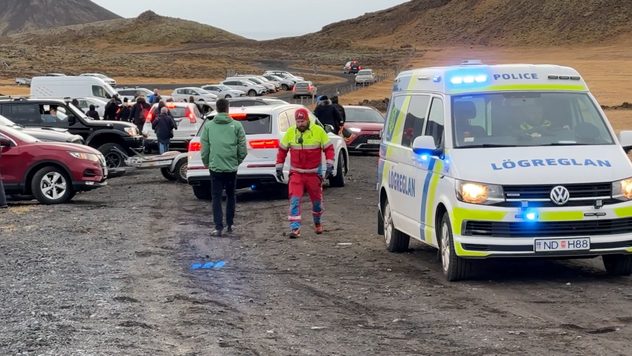
The 3700 residents of Grindavík who were fully evacuated, were allowed to return to the evacuated town for a short time on Tuesday November 14th to collect personal belongings.

Residents of the evacuated town were allowed to return home briefly to collect personal belongings.
Residents of the evacuated town were allowed to return home briefly to collect personal belongings. - © Weather & Radar

Every car was checked, but not every resident was allowed into the town because the crowd was so large. There was a long traffic jam with a wait of several hours. In Grindavík itself, each household was only given five minutes to complete tasks.

However, on Tuesday afternoon when they arrived, there was another new alarm and the area had to be completely evacuated once again. The reason for this was a high level of sulphur dioxide in the air, caused by volcanic gases.

Earthquakes caused by the rupture of rock layers

In recent weeks there have been thousands of earthquakes in the area. The tremors are caused by the movement of magma, which has been collecting in a kind of storage chamber at a depth of four to five kilometres for about two and a half weeks.

To make more room, magma pushes itself through cracks and crevices in the rock, which repeatedly breaks open. This breaking up of the rock layers can be felt as an earthquake.

If the magma reaches the earth's surface somewhere during these processes, the volcanic eruption begins. However, it is difficult to specify the exact time period that this may happen.

The exact location can also only be roughly estimated. The magma on Iceland is currently around 500 metres below the earth's surface.

Magma channel directly beneath Grindavík

The magma channel currently runs directly beneath the town of Grindavík and is around 15 km long. It is also possible that the magma will initially move sideways towards the coast and that the eruption could even take place under the sea.

Over 24,000 earthquakes in one monthread more
Weather & Radar editorial team
More on the topic
Half of England now in drought. Joining North Wales. . . Wednesday, 29 July 2026
Dry section of the River Thames beneath a small stone bridge, with the riverbed exposed and cracked after prolonged, dry weather, while a person walks along the roadside above.
Wednesday, 29 July 2026

Joining North Wales

Half of England now in drought
Forest fires are getting out of control. Spain and France. . . Saturday, 25 July 2026
A split-screen image featuring a photograph and a weather map. On the left, thick, dark-grey smoke rises from several fire sites in a wooded coastal area; a calm stretch of water can be seen in the foreground. On the right, a weather map shows south-western France and northern Spain. A red arrow points from the Atlantic towards the French Atlantic coast, symbolising an onshore wind. Sunny weather is forecast for Bordeaux at around 20 degrees, and Bilbao is also expected to be sunny at around 27 degrees. A large warning sign with a flame symbol indicates an increased risk of forest fires.
Saturday, 25 July 2026

Spain and France

Forest fires are getting out of control
Heavier rainfall over the week for some. Ireland & Scotland. . . Tuesday, 28 July 2026
Split image showing a Europe rainfall accumulation forecast map on the left with the highest totals across the UK, Ireland, and Scandinavia, and a satellite weather map on the right with a broad band of rain stretching across Ireland, Scotland, and northern Britain, highlighted by a rain cloud icon.
Tuesday, 28 July 2026

Ireland & Scotland

Heavier rainfall over the week for some
All weather news
This might also interest you
Turbulent weather in the Canary Islands. Storm and rain. . . Friday, 12 December 2025
Weather graphic showing rain and wind fields over the Canary Islands and a central warning symbol.
Friday, 12 December 2025

Storm and rain

Turbulent weather in the Canary Islands
Flooding, gales, and heavy snow. Storm Chandra. . . Tuesday, 27 January 2026
Split image showing aerial flooding in a town with muddy water covering roads on the left, and a rural road on the right blocked by heavy snowfall with vans stopped and a person walking in snow.
Tuesday, 27 January 2026

Storm Chandra

Flooding, gales, and heavy snow
A frozen start to the weekend. Icy conditions. . . Friday, 13 February 2026
UK temperature map dated 14.02 showing widespread subzero values in blue shading, with readings such as −4 in Glasgow, −3 in Dublin, and −2 in London, alongside a blue thermometer icon.
Friday, 13 February 2026

Icy conditions

A frozen start to the weekend
All articles
Weather & Radar

Weather & Radar is also available on

Google Play StoreApp Store

Company

Contact us Privacy Policy Legal info Accessibility statement

Services

Uploader

Socials

facebooktwittertikToklinkList