Home
Weather London
WeatherRadar
RainfallRadar
TemperatureRadar
WindRadar
LightningRadar
Weather News
Editor's Pick
Discover the app
Weather widget
Contact us
Apps
Career
    Home / Weather News /

    Record breaking: Temperatures soar to 38C

17:50
18 July 2022

Record breaking
Temperatures soar to 38C

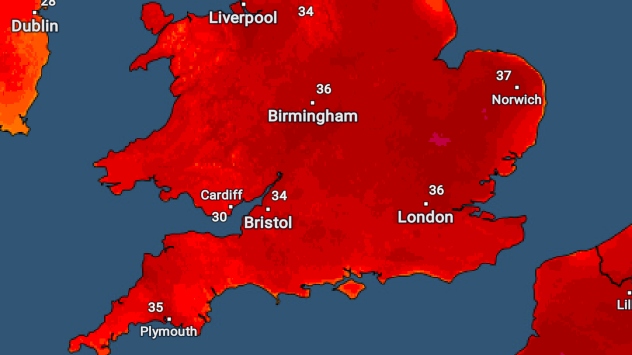
Maximum temperatures across England and Wales today

Amidst unprecedented heat across the British Isles, temperatures have soared to 37.1C in Wales, breaking it's all-time record.

Wales smashed their all-time temperature record today, with a staggering 37.1C at Hawarden, Flintshire, breaking its previous record of 35.2C from August 1990 by almost 2C.

Whilst most cities saw their hottest ever day, with date records broken, all nations, with the exception of Wales, narrowly missed their all-time record.

The current or previous records, versus today's temperatures can be seen below:

LocationRecord T (C)Today's T (C)
England38.738.1
Wales35.237.1
Scotland32.931.3
N Ireland31.331.1
ROI33.333.0

Ireland did however see its hottest day in 135 years, as Phoenix Park in Dublin recorded 33C, the highest ever July temperature. The all-time record is just 0.3C higher, with similarly narrow margins in Northern Ireland.

Whilst England climbed to 38.1C at Santon Downham, it was just 0.6C shy of the all-time record, and in Jersey, a new island record of 37.5C was reached.

The highest minimum for the UK, currently stood at 23.9C is also likely to be shattered overnight, terming it a 'tropical night' for many as temperatures do not fall below 20C. Read here for tips on how to keep cool.

Tomorrow is going to be even more of a scorcher with further records expected to tumble as we potentially hit 40C, so keep an eye on the UV Index, the forecast and also current observations on our TemperatureRadar here.

Weather & Radar editorial team
More on the topic
Severe weather hits Mallorca and Italy. Severe thunderstorms. . . Thursday, 10 September 2026
Numerous thunderstorms are sweeping across La Palma. The many lightning symbols on the radar and lightning map show that there is heavy lightning activity across large parts of the island. The thunderstorms are striking particularly in the island’s interior and in the south. On the right, you can see the aftermath: a large fallen tree has buried a car beneath it. Emergency services are clearing up the damage. So, along with the thunderstorms, not only heavy rain but also gusts of wind can become a problem.
Thursday, 10 September 2026

Severe thunderstorms

Severe weather hits Mallorca and Italy
Severe weather rolls on in Europe. Heavy rain and hail. . . Thursday, 17 September 2026
Weather radar showing severe thunderstorms and frequent lightning over northern Italy.
Thursday, 17 September 2026

Heavy rain and hail

Severe weather rolls on in Europe
Huge low-pressure system off Iceland. Impacting the UK & Ireland. . . Wednesday, 16 September 2026
WeatherRadar showing a large low-pressure system over the North Atlantic between Greenland and Iceland.
Wednesday, 16 September 2026

Impacting the UK & Ireland

Huge low-pressure system off Iceland
All weather news
This might also interest you
Seasonal warmth between spring thunder. Your weather - Your shots. . . Sunday, 19 April 2026
Split image showing coastal sunset with layered lenticular clouds over rooftops and palm trees on the left, and a green valley with river and hills under soft daylight on the right.
Sunday, 19 April 2026

Your weather - Your shots

Seasonal warmth between spring thunder
Long-term trends need a pinch of salt. 40 °C in July?. . . Tuesday, 30 June 2026
Temperature radar of 2022 heatwave where the all-time temperature record in the UK was set. Warning symbol overlain.
Tuesday, 30 June 2026

40 °C in July?

Long-term trends need a pinch of salt
Super Typhoon Bavi threatens Taiwan. Up to 1,000 mm of rain. . . Wednesday, 8 July 2026
The image shows an intense tropical cyclone over the western Pacific, east of Taiwan and the Philippines. The centre of the system is depicted as a light purple and white vortex with a clearly visible eye, surrounded by a ring of red and orange areas indicating the strongest wind speeds. A white arrow marks the typhoon’s predicted track towards the north-west, in the direction of Taiwan. To the west of the storm lie the Philippines, with the cities of Manila and Cebu; to the north of these lies Taiwan, with Taipei. Further west, the Chinese coast, including Hong Kong, and parts of Vietnam can be seen. The coloured wind map shows predominantly green areas outside the storm’s core, indicating significantly weaker winds. White streamlines illustrate the typhoon’s anti-clockwise circulation in the Northern Hemisphere. The highest wind speeds are concentrated around the eye of the cyclone.
Wednesday, 8 July 2026

Up to 1,000 mm of rain

Super Typhoon Bavi threatens Taiwan
All articles
Weather & Radar

Weather & Radar is also available on

Google Play StoreApp Store

Company

Contact us Privacy Policy Legal info Accessibility statement

Services

Uploader

Socials

facebooktwittertikToklinkList