Home
Weather London
WeatherRadar
RainfallRadar
TemperatureRadar
WindRadar
LightningRadar
Weather News
Editor's Pick
Discover the app
Weather widget
Contact us
Apps
Career
    Home / Editor's Pick /

    Rare wintry phenomenon: 'Snownado' spotted in Scotland

11:30
9 March 2023

Rare wintry phenomenon
'Snownado' spotted in Scotland

A 'snownado' filmed in Scotland on Tuesday. - © Storyful

A rare 'snownado' was filmed on the Shetland Islands this week as wintry conditions returned to the UK and Ireland.

The footage above was filmed by a farmer on Tuesday as he fed his sheep in Sandness.

Also known as 'snow devils' these rare events occur when wind shear generates a vortex over snow, lifting the snow into a spinning column. Despite the name, these events cannot compare to actual tornadoes. Packing much weaker winds and posing little danger.

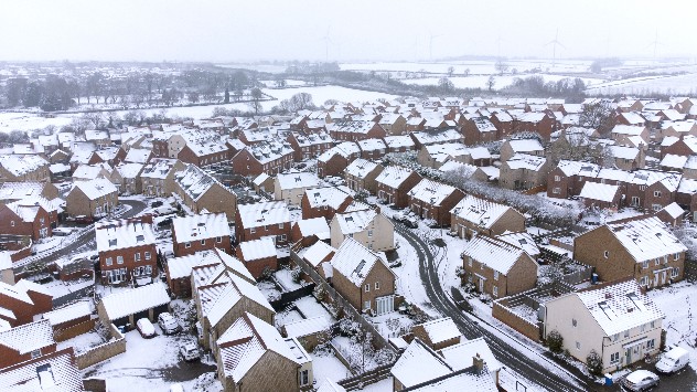
Snow town scene
It felt like winter had returned in Burton Latimer, Northamptonshire this morning as snow spreads across the country. - © picture alliance

This spectacular display arrived amid freezing temperatures and heavy snowfall for much of the UK and Ireland this week.

The wintry weather will continue throughout Thursday particularly over Ireland, northern England, and southern Scotland.

Snowy scenes from across the countryread also

Days of ongoing snowfall has resulted in dangerous conditions in some areas, a multi-vehicle crash closed the M5 overnight while tens of thousands of homes are without power in the east and southeast of England.

Wednesday night also saw the lowest temperature of the year in Altnaharra, Scotland with a frigid -16°C recorded in the Highlands hamlet.

It marks the second consecutive night seeing 2023's lowest temperature after -15.2°C was recorded in Kinbrace, Scotland on Tuesday.

Keep an eye on the conditions near you at all times with the WeatherRadar.

Ryan Hathaway
More on the topic
First autumn views of the season. Your weather - Your shots. . . Sunday, 27 September 2026
Split image showing a vivid double rainbow over green fields beside a sunny marina filled with boats beneath blue skies.
Sunday, 27 September 2026

Your weather - Your shots

First autumn views of the season
Warm weather despite the start of autumn. Temperatures worldwide. . . Wednesday, 23 September 2026
Temperature Radar for the Northern Hemisphere
Wednesday, 23 September 2026

Temperatures worldwide

Warm weather despite the start of autumn
First taste of winter in the Alps. White mountain peaks. . . Friday, 25 September 2026
Winter scenery in the Alps along the Großglockner High Alpine Road
Friday, 25 September 2026

White mountain peaks

First taste of winter in the Alps
All weather news
This might also interest you
Storm Chandra makes impact. Severe gales & heavy rain. . . Tuesday, 27 January 2026
Split image showing strong winds over the UK on a forecast map and widespread rain and snow on a weather radar map.
Tuesday, 27 January 2026

Severe gales & heavy rain

Storm Chandra makes impact
Super Typhoon Bavi threatens Taiwan. Up to 1,000 mm of rain. . . Wednesday, 8 July 2026
The image shows an intense tropical cyclone over the western Pacific, east of Taiwan and the Philippines. The centre of the system is depicted as a light purple and white vortex with a clearly visible eye, surrounded by a ring of red and orange areas indicating the strongest wind speeds. A white arrow marks the typhoon’s predicted track towards the north-west, in the direction of Taiwan. To the west of the storm lie the Philippines, with the cities of Manila and Cebu; to the north of these lies Taiwan, with Taipei. Further west, the Chinese coast, including Hong Kong, and parts of Vietnam can be seen. The coloured wind map shows predominantly green areas outside the storm’s core, indicating significantly weaker winds. White streamlines illustrate the typhoon’s anti-clockwise circulation in the Northern Hemisphere. The highest wind speeds are concentrated around the eye of the cyclone.
Wednesday, 8 July 2026

Up to 1,000 mm of rain

Super Typhoon Bavi threatens Taiwan
Historic Storm Éowyn arrives. On this day.... . . Saturday, 24 January 2026
Split image showing a person in a yellow jacket struggling against strong winds and heavy rain on a street at night on the left, and an Irish wind forecast map on the right with red and purple shading, gusts up to 75 mph, and a wind warning icon, divided by a curved white line.
Saturday, 24 January 2026

On this day...

Historic Storm Éowyn arrives
All articles
Weather & Radar

Weather & Radar is also available on

Google Play StoreApp Store

Company

Contact us Privacy Policy Legal info Accessibility statement

Services

Uploader

Socials

facebooktwittertikToklinkList