Home
Weather London
WeatherRadar
RainfallRadar
TemperatureRadar
WindRadar
LightningRadar
Weather News
Editor's Pick
Discover the app
Weather widget
Contact us
Apps
Career
    Home / Editor's Pick /

    Rare visitors from space – two comets visible in the night sky in October

09:00
10 October 2025

Rare visitors this month
Two comets visible at once

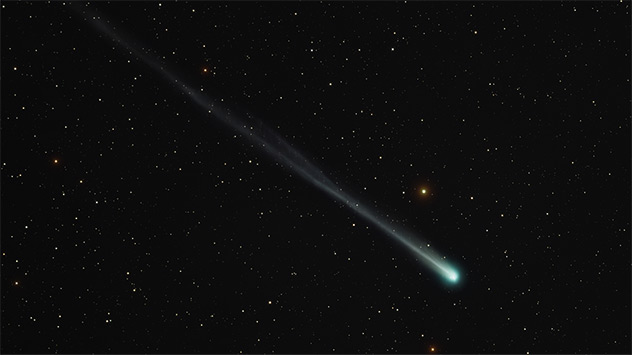
Comet "Lemmon" (C/2025 A6) in the sky at the beginning of October
Comet "Lemmon" (C/2025 A6) in the sky at the beginning of October - © Miloslav Roháček

Two comets will be visible in the night sky in the second half of October: "Swan" and "Lemmon".

Swan was only discovered in September and will approach Earth to within around 30 million kilometres.

It will reach its maximum brightness around October 20th and can even be seen with the naked eye in clear weather. Especially in the evening hours, the comet is clearly visible in the south-western dark sky, offering amateur astronomers an impressive spectacle.

The other comet, Lemmon, is an extremely rare visitor: its last visit was over 1,300 years ago. At the end of October, it will reach its closest point to Earth and will then be particularly bright. Early risers can observe it with binoculars in the early hours of the morning, when it is very high in the sky.

Both celestial bodies consist of ice, dust, and rock – ancient remnants from the early days of our solar system.

WeatherRadar: Clear skies or clouds?Evening view
Dr. Bernd Maurer
Ryan Hathaway
More on the topic
Huge low-pressure system off Iceland. Impacting the UK & Ireland. . . Wednesday, 16 September 2026
WeatherRadar showing a large low-pressure system over the North Atlantic between Greenland and Iceland.
Wednesday, 16 September 2026

Impacting the UK & Ireland

Huge low-pressure system off Iceland
Europe split in two distinct patterns. Autumn meets summer. . . Tuesday, 22 September 2026
Weather maps show a storm over the North Atlantic and temperatures of up to 37 degrees in Spain and Portugal.
Tuesday, 22 September 2026

Autumn meets summer

Europe split in two distinct patterns
Hurricane threat off the coast of Mexico. Storm and rain. . . Monday, 21 September 2026
Split image showing a powerful tropical system southwest of Acapulco on a wind map and palm trees bending sharply in strong winds.
Monday, 21 September 2026

Storm and rain

Hurricane threat off the coast of Mexico
All weather news
This might also interest you
Historic Storm Éowyn arrives. On this day.... . . Saturday, 24 January 2026
Split image showing a person in a yellow jacket struggling against strong winds and heavy rain on a street at night on the left, and an Irish wind forecast map on the right with red and purple shading, gusts up to 75 mph, and a wind warning icon, divided by a curved white line.
Saturday, 24 January 2026

On this day...

Historic Storm Éowyn arrives
Storm Chandra makes impact. Severe gales & heavy rain. . . Tuesday, 27 January 2026
Split image showing strong winds over the UK on a forecast map and widespread rain and snow on a weather radar map.
Tuesday, 27 January 2026

Severe gales & heavy rain

Storm Chandra makes impact
Seasonal warmth between spring thunder. Your weather - Your shots. . . Sunday, 19 April 2026
Split image showing coastal sunset with layered lenticular clouds over rooftops and palm trees on the left, and a green valley with river and hills under soft daylight on the right.
Sunday, 19 April 2026

Your weather - Your shots

Seasonal warmth between spring thunder
All articles
Weather & Radar

Weather & Radar is also available on

Google Play StoreApp Store

Company

Contact us Privacy Policy Legal info Accessibility statement

Services

Uploader

Socials

facebooktwittertikToklinkList