Home
Weather London
WeatherRadar
RainfallRadar
TemperatureRadar
WindRadar
LightningRadar
Weather News
Editor's Pick
Discover the app
Weather widget
Contact us
Apps
Career
    Home / Editor's Pick /

    Rain coming but not enough - South-east saw a record-breaking drought

08:50
15 October 2026

Rain coming but not enough
South-east saw a record-breaking drought

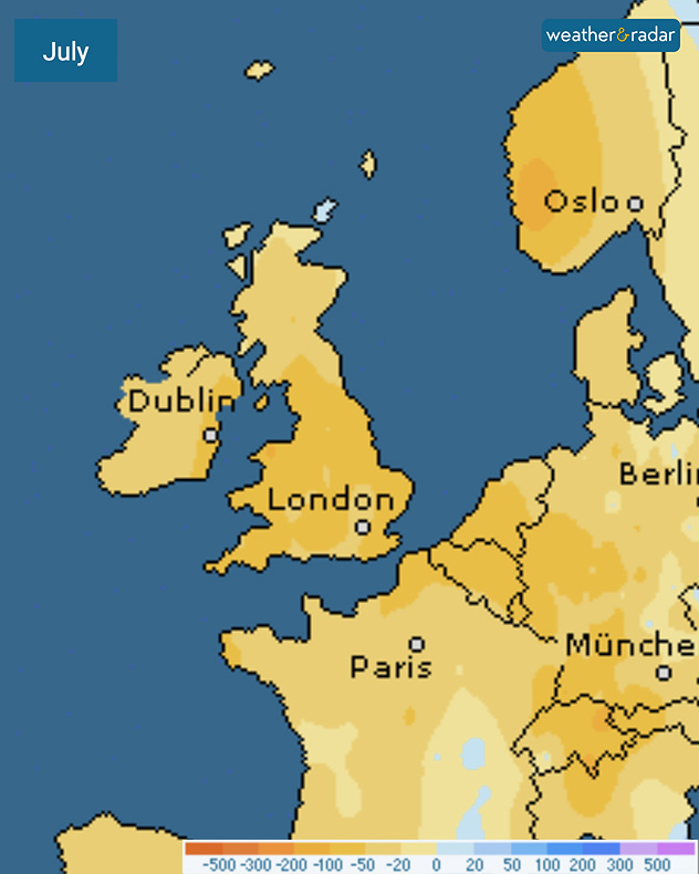
July rainfall anomaly map showing yellow and orange areas across the UK, Ireland and western Europe, indicating below-average rainfall on the colour scale.
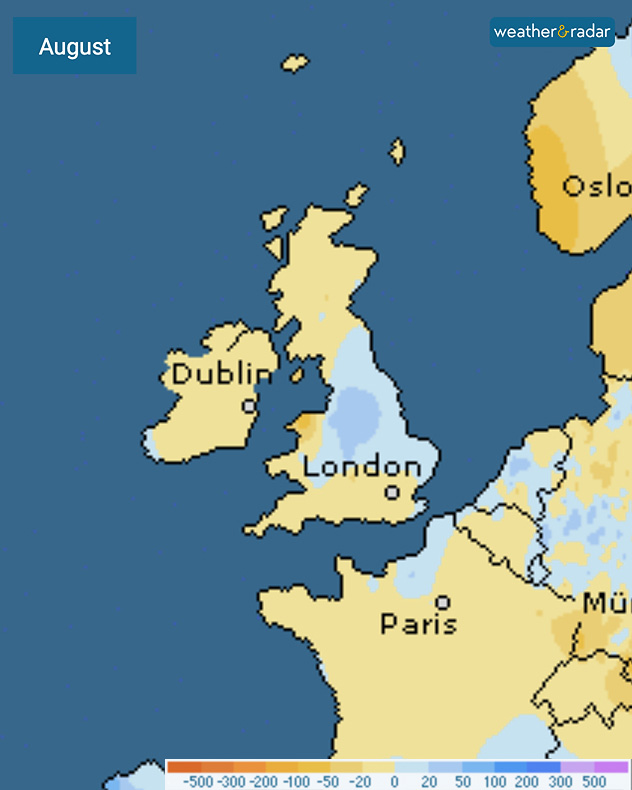
August rainfall anomaly map showing below-average rainfall across Ireland, Scotland, and France, with wetter blue areas over central and eastern England.
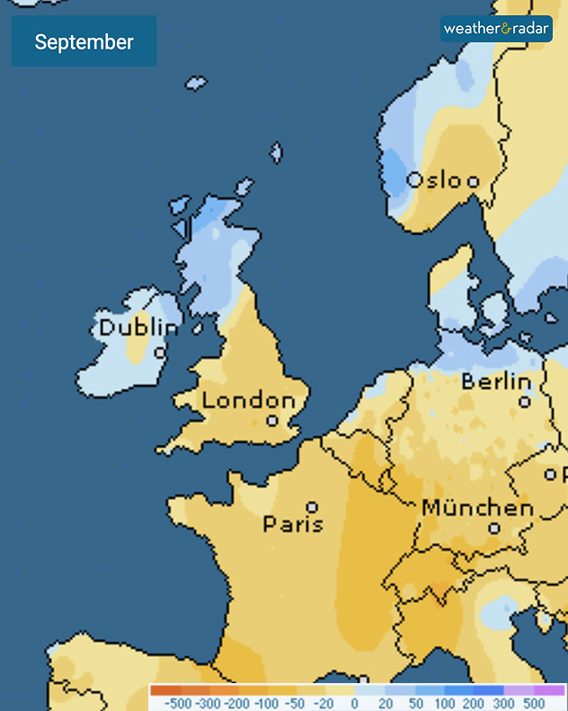
September rainfall anomaly map showing wetter blue areas across Scotland and Ireland, with drier yellow regions over England, France, and Germany.
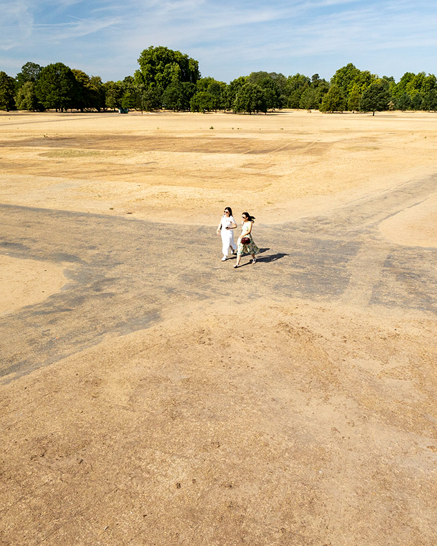
Two people walk across a vast expanse of dry yellow-brown grassland under a blue sky, with green trees lining the distant edge.
1/4
July saw very little rainfall across the UK, Ireland, and much of Europe.

New figures confirm a record-breaking summer drought for south-east England.

Data from the Environment Agency has confirmed the driest three-month spell up to September ever for the south-east region into Hertfordshire and London.

From July to September, the south-east region saw just 54% of its expected summer rainfall resulting in hosepipe bans from six water companies which are still live now.

The drought is still biting elsewhere too. In the south-west, Wessex Water ended September with reservoirs at just 28% of total capacity. Lower than the levels seen in 1976.

In Yorkshire, the River Esk recorded its lowest mean flow for September on record, and with the county going through its fifth driest spring to summer season since 1871.

As we move deeper into autumn, rain is returning to the UK and Ireland, with a band moving through Friday morning, but more sustained rainfall is needed to full recover from the extraordinarily dry summer season.

Ryan Hathaway

More on the topic

Storm Boelo named. Weekend impacts. . . Thursday, 22 October 2026
Split weather maps showing Storm Boelo northwest of Scotland, winds reaching 50 mph near Glasgow and Liverpool, and spiralling Atlantic rain bands.
Thursday, 22 October 2026

Weekend impacts

Storm Boelo named
Severe flooding in the south of France. Roads become rivers. . . Wednesday, 21 October 2026
Weather radar shows heavy rainfall over southern France, northern Italy, Corsica and Sardinia. A warning symbol indicates a risk of flooding.
Wednesday, 21 October 2026

Roads become rivers

Severe flooding in the south of France
Storm Austen approaches. What to expect tonight. . . Thursday, 22 October 2026
Split image showing a wind map with 65 mph near Brest and a swirling storm south of England, beside a man wearing glasses and holding a microphone.
Thursday, 22 October 2026

What to expect tonight

Storm Austen approaches
All weather news

This might also interest you

New records for England and Wales. Broken again tomorrow?. . . Thursday, 25 June 2026
Temperature map of southwest Britain on 25.06 showing extreme heat across southern Wales and southwest England, with Bute Park in Cardiff highlighted at 34.2°C and Yeovilton at 36.4°C amid widespread deep red heat zones.
Thursday, 25 June 2026

Broken again tomorrow?

New records for England and Wales
Long-term trends need a pinch of salt. 40 °C in July?. . . Tuesday, 30 June 2026
Temperature radar of 2022 heatwave where the all-time temperature record in the UK was set. Warning symbol overlain.
Tuesday, 30 June 2026

40 °C in July?

Long-term trends need a pinch of salt
Super Typhoon Bavi threatens Taiwan. Up to 1,000 mm of rain. . . Wednesday, 8 July 2026
The image shows an intense tropical cyclone over the western Pacific, east of Taiwan and the Philippines. The centre of the system is depicted as a light purple and white vortex with a clearly visible eye, surrounded by a ring of red and orange areas indicating the strongest wind speeds. A white arrow marks the typhoon’s predicted track towards the north-west, in the direction of Taiwan. To the west of the storm lie the Philippines, with the cities of Manila and Cebu; to the north of these lies Taiwan, with Taipei. Further west, the Chinese coast, including Hong Kong, and parts of Vietnam can be seen. The coloured wind map shows predominantly green areas outside the storm’s core, indicating significantly weaker winds. White streamlines illustrate the typhoon’s anti-clockwise circulation in the Northern Hemisphere. The highest wind speeds are concentrated around the eye of the cyclone.
Wednesday, 8 July 2026

Up to 1,000 mm of rain

Super Typhoon Bavi threatens Taiwan
All articles
Weather & Radar

Weather & Radar is also available on

Google Play StoreApp Store

Company

Contact us Privacy Policy Legal info Accessibility statement

Services

Uploader

Socials

facebooktwittertikToklinkList