Home
Weather London
WeatherRadar
RainfallRadar
TemperatureRadar
WindRadar
LightningRadar
Weather News
Editor's Pick
Discover the app
Weather widget
Contact us
Apps
Career
    Home / Editor's Pick /

    Prelude to Austen as winds grow and rain spreads Wednesday

08:59
21 October 2026

Prelude to Austen
Winds grow and rain spreads Wednesday

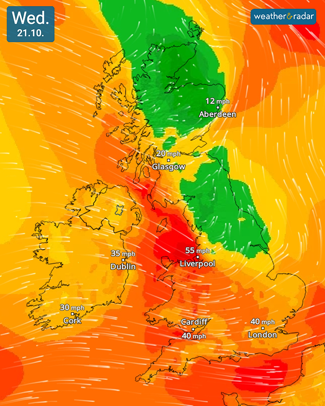
Wind forecast for Wednesday 21.10 showing 55 mph near Liverpool, 40 mph near Cardiff and London, and lighter 12 to 20 mph winds across Scotland.
Winds pack a punch through Wednesday.

While all eyes are on Friday and Storm Austen, Wednesday brings an early taste of the storm with strong gusting winds and spreading rain.

The strongest gusts will be felt in north-west Wales and England, reaching around 60 mph in Holyhead and 55 mph in Liverpool, slightly lower gusts of 40 to 50 mph spread across Wales and the south-west at times in the early afternoon.

Rain grows heavier at times too. With accumulations of up to 30 mm expected by the end of the day along the southern coasts of Hampshire and Dorset, and around the Elan Valley in Waves. Some surface flooding could be seen.

Before reaching the UK with full force, eastern Ireland first feels the impact of the wind, gusts of up to 45 mph (70 km/h) are expected in Dublin. Scotland is spared from the gusting winds until the late afternoon, into the evening.

Rain and winds from Austen at the end of the week will be more severe than what we see Wednesday. Gales could reach speeds of 70 mph in exposed south-western regions of England.

Some uncertainty still remains on the exact path of Austen, impacts could be greater or lesser than predicted until this become clear.

Ryan Hathaway

More on the topic

Europe caught between winter and summer. Frost and warmth. . . Friday, 6 November 2026
Temperature Radar showing freezing temperatures in northern and eastern Europe and temperatures above 20 degrees in Spain.
Friday, 6 November 2026

Frost and warmth

Europe caught between winter and summer
Gloomy evening with a few spots of rain. Bonfire Night. . . Thursday, 5 November 2026
Split image showing a cloudy UK weather map with temperatures of 8–9°C alongside colourful fireworks bursting through smoke in the night sky.
Thursday, 5 November 2026

Bonfire Night

Gloomy evening with a few spots of rain
Europe set for a change in the weather. Turning more unsettled. . . Monday, 9 November 2026
European weather map showing low pressure over Scandinavia, pink snow bands across Norway and Sweden, blue rain areas and arrows indicating airflow.
Monday, 9 November 2026

Turning more unsettled

Europe set for a change in the weather
All weather news

This might also interest you

Flooding, gales, and heavy snow. Storm Chandra. . . Tuesday, 27 January 2026
Split image showing aerial flooding in a town with muddy water covering roads on the left, and a rural road on the right blocked by heavy snowfall with vans stopped and a person walking in snow.
Tuesday, 27 January 2026

Storm Chandra

Flooding, gales, and heavy snow
A frozen start to the weekend. Icy conditions. . . Friday, 13 February 2026
UK temperature map dated 14.02 showing widespread subzero values in blue shading, with readings such as −4 in Glasgow, −3 in Dublin, and −2 in London, alongside a blue thermometer icon.
Friday, 13 February 2026

Icy conditions

A frozen start to the weekend
Long-term trends need a pinch of salt. 40 °C in July?. . . Tuesday, 30 June 2026
Temperature radar of 2022 heatwave where the all-time temperature record in the UK was set. Warning symbol overlain.
Tuesday, 30 June 2026

40 °C in July?

Long-term trends need a pinch of salt
All articles
Weather & Radar

Weather & Radar is also available on

Google Play StoreApp Store

Company

Contact us Privacy Policy Legal info Accessibility statement

Services

Uploader

Socials

facebooktwittertikToklinkList