Home
Weather London
WeatherRadar
RainfallRadar
TemperatureRadar
WindRadar
LightningRadar
Weather News
Editor's Pick
Discover the app
Weather widget
Contact us
Apps
Career
    Home / Editor's Pick /

    Popcorn storms - Thunderstorm risk to start the week

07:44
9 June 2026

Popcorn storms
Thunderstorm risk to start the week

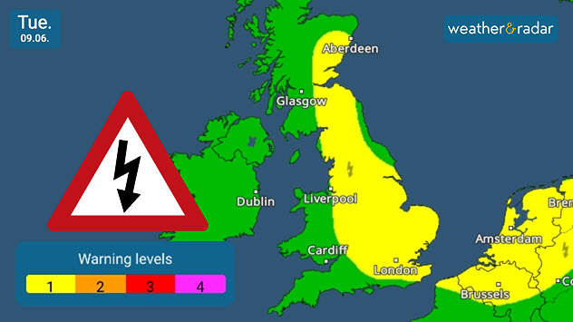
Weather warning map of the UK on Tuesday 09.06 showing a yellow thunderstorm alert area extending from northeast Scotland through eastern England to the southeast coast, with a warning triangle, lightning symbols, and a colour-coded alert scale.
Low-level warnings for thunderstorms run through England into eastern Scotland.

The unsettled spell of weather is not over yet, with many parts of England and eastern Scotland still seeing a chance of a stormy start to the week.

Low pressure near Iceland keeps swirling winds moving across the UK and Ireland, with conditions over England ripe for more thunderstorm development.

Currently, thunderstorms are most likely in England, though away the south coast and south-west, and eastern Scotland. As conditions change into Tuesday, there is also a chance of development in Ireland and Wales too.

Much like the thunder and lightning seen last week, these would form with "popcorn convection". Small, short-lived, and relatively weak outbreaks that develop quickly.

Unlike more traditional summer thunderstorms, which are often more organised and long-lived, these tend to only last around an hour or so before dissipating.

Therefore, it's best to keep an eye on the WeatherRadar as they begin to bubble, and the LightningRadar once strikes start.

Ryan Hathaway
More on the topic
New heatwave in southern Europe. Up to 45 degrees in Spain. . . Tuesday, 21 July 2026
Split temperature map showing extreme heat across Spain on the left and Greece on the right, with temperatures reaching 44°C near Murcia, around 40°C in parts of Greece, and a large thermometer icon highlighting dangerous heat.
Tuesday, 21 July 2026

Up to 45 degrees in Spain

New heatwave in southern Europe
Parts of England inching towards drought. Low rivers & reservoirs. . . Wednesday, 22 July 2026
People relaxing in a park during hot weather ,with one person sunbathing on dry yellow grass beneath large leafy trees under a blue sky with scattered fair-weather clouds.
Wednesday, 22 July 2026

Low rivers & reservoirs

Parts of England inching towards drought
Drought across large parts of Europe. High fire risk. . . Monday, 20 July 2026
Split image showing a Europe rainfall anomaly map on the left with widespread dry conditions across much of the continent, and a cracked, parched field on the right alongside a wildfire warning symbol highlighting elevated fire risk.
Monday, 20 July 2026

High fire risk

Drought across large parts of Europe
All weather news
This might also interest you
Storm Chandra makes impact. Severe gales & heavy rain. . . Tuesday, 27 January 2026
Split image showing strong winds over the UK on a forecast map and widespread rain and snow on a weather radar map.
Tuesday, 27 January 2026

Severe gales & heavy rain

Storm Chandra makes impact
Flooding, gales, and heavy snow. Storm Chandra. . . Tuesday, 27 January 2026
Split image showing aerial flooding in a town with muddy water covering roads on the left, and a rural road on the right blocked by heavy snowfall with vans stopped and a person walking in snow.
Tuesday, 27 January 2026

Storm Chandra

Flooding, gales, and heavy snow
Long-term trends need a pinch of salt. 40 °C in July?. . . Tuesday, 30 June 2026
Temperature radar of 2022 heatwave where the all-time temperature record in the UK was set. Warning symbol overlain.
Tuesday, 30 June 2026

40 °C in July?

Long-term trends need a pinch of salt
All articles
Weather & Radar

Weather & Radar is also available on

Google Play StoreApp Store

Company

Contact us Privacy Policy Legal info Accessibility statement

Services

Uploader

Socials

facebooktwittertikToklinkList