Home
Weather London
WeatherRadar
RainfallRadar
TemperatureRadar
WindRadar
LightningRadar
Weather News
Editor's Pick
Discover the app
Weather widget
Contact us
Apps
Career
    Home / Editor's Pick /

    Overnight low drops - More comfortable night's sleep

10:09
5 August 2026

Overnight low drops
More comfortable night's sleep

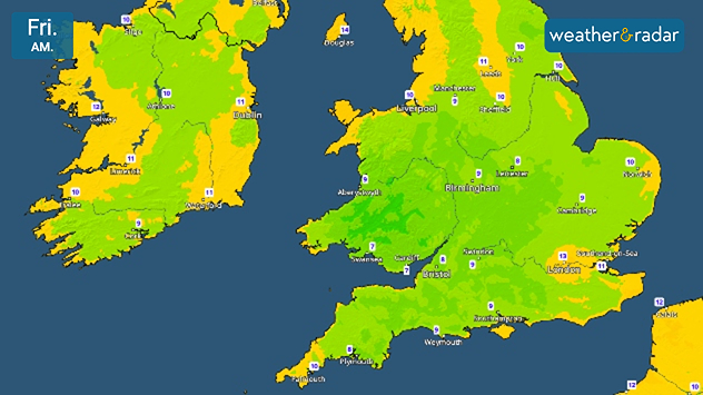
Friday morning temperature map of the UK and Ireland showing cool early conditions, with temperatures generally between 7°C and 13°C. Lowest values are around 7°C in parts of southwest England and South Wales, while Ireland ranges from 9°C to 11°C and northern Scotland reaches around 10°C.
Single digits seen on the TemperatureRadar's lows reflects the cooler night into Friday.

While we didn't quite reach the threshold for tropical nights this time, it has been quite uncomfortable for many recently. Now, overnight temperatures are cooling.

From Wednesday evening, daily lows fall to single digits across large parts of Wales, central to south-western England, and the south of Ireland.

Further north, overnight temperatures did not reach the same uncomfortable highs as elsewhere but still sees lows drop from the mid-teens to around 10°C.

The drop reflects a general trend for the rest of the week with a slightly cooler feel in the air.

Into the weekend, conditions change again with temperatures rising by Saturday into the new week with a renewed burst of heat.

Keep an eye on the TemperatureRadar as we get closer, and check the 14-day weather on the home screen for a longer outlook.

London

Su
13
23
Mo
14
19
Tu
16
25
We
20
22
Th
14
21
Fr
11
19
Sa
12
20
Su
13
20
Mo
13
21
Tu
14
22
We
14
22
Th
15
23
Fr
15
22
Sa
14
18
Max (°C)
Min (°C)
moreless

Manchester

Su
10
19
Mo
7
17
Tu
11
23
We
18
21
Th
11
18
Fr
11
18
Sa
10
17
Su
11
17
Mo
12
19
Tu
12
19
We
13
19
Th
13
19
Fr
13
16
Sa
11
14
Max (°C)
Min (°C)
moreless

Dublin

Su
14
16
Mo
7
17
Tu
12
19
We
15
18
Th
10
17
Fr
13
17
Sa
9
17
Su
11
17
Mo
11
18
Tu
10
17
We
12
18
Th
12
17
Fr
11
15
Sa
9
15
Max (°C)
Min (°C)
moreless

Edinburgh

Su
13
15
Mo
8
17
Tu
6
16
We
15
20
Th
12
17
Fr
11
17
Sa
9
16
Su
12
17
Mo
12
18
Tu
11
18
We
12
19
Th
11
17
Fr
11
15
Sa
11
15
Max (°C)
Min (°C)
moreless

Cardiff

Su
10
19
Mo
8
18
Tu
12
23
We
17
21
Th
11
19
Fr
11
19
Sa
12
19
Su
12
18
Mo
12
19
Tu
13
20
We
13
20
Th
14
19
Fr
13
18
Sa
13
16
Max (°C)
Min (°C)
moreless
Ryan Hathaway
More on the topic
Europe split in two distinct patterns. Autumn meets summer. . . Tuesday, 22 September 2026
Weather maps show a storm over the North Atlantic and temperatures of up to 37 degrees in Spain and Portugal.
Tuesday, 22 September 2026

Autumn meets summer

Europe split in two distinct patterns
Hurricane threat off the coast of Mexico. Storm and rain. . . Monday, 21 September 2026
Split image showing a powerful tropical system southwest of Acapulco on a wind map and palm trees bending sharply in strong winds.
Monday, 21 September 2026

Storm and rain

Hurricane threat off the coast of Mexico
Huge low-pressure system off Iceland. Impacting the UK & Ireland. . . Wednesday, 16 September 2026
WeatherRadar showing a large low-pressure system over the North Atlantic between Greenland and Iceland.
Wednesday, 16 September 2026

Impacting the UK & Ireland

Huge low-pressure system off Iceland
All weather news
This might also interest you
Long-term trends need a pinch of salt. 40 °C in July?. . . Tuesday, 30 June 2026
Temperature radar of 2022 heatwave where the all-time temperature record in the UK was set. Warning symbol overlain.
Tuesday, 30 June 2026

40 °C in July?

Long-term trends need a pinch of salt
Historic Storm Éowyn arrives. On this day.... . . Saturday, 24 January 2026
Split image showing a person in a yellow jacket struggling against strong winds and heavy rain on a street at night on the left, and an Irish wind forecast map on the right with red and purple shading, gusts up to 75 mph, and a wind warning icon, divided by a curved white line.
Saturday, 24 January 2026

On this day...

Historic Storm Éowyn arrives
Super Typhoon Bavi threatens Taiwan. Up to 1,000 mm of rain. . . Wednesday, 8 July 2026
The image shows an intense tropical cyclone over the western Pacific, east of Taiwan and the Philippines. The centre of the system is depicted as a light purple and white vortex with a clearly visible eye, surrounded by a ring of red and orange areas indicating the strongest wind speeds. A white arrow marks the typhoon’s predicted track towards the north-west, in the direction of Taiwan. To the west of the storm lie the Philippines, with the cities of Manila and Cebu; to the north of these lies Taiwan, with Taipei. Further west, the Chinese coast, including Hong Kong, and parts of Vietnam can be seen. The coloured wind map shows predominantly green areas outside the storm’s core, indicating significantly weaker winds. White streamlines illustrate the typhoon’s anti-clockwise circulation in the Northern Hemisphere. The highest wind speeds are concentrated around the eye of the cyclone.
Wednesday, 8 July 2026

Up to 1,000 mm of rain

Super Typhoon Bavi threatens Taiwan
All articles
Weather & Radar

Weather & Radar is also available on

Google Play StoreApp Store

Company

Contact us Privacy Policy Legal info Accessibility statement

Services

Uploader

Socials

facebooktwittertikToklinkList