Home
Weather London
WeatherRadar
RainfallRadar
TemperatureRadar
WindRadar
LightningRadar
Weather News
Editor's Pick
Discover the app
Weather widget
Contact us
Apps
Career
    Home / Editor's Pick /

    Overnight low drops - More comfortable night's sleep

10:09
5 August 2026

Overnight low drops
More comfortable night's sleep

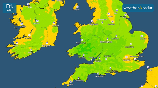
Friday morning temperature map of the UK and Ireland showing cool early conditions, with temperatures generally between 7°C and 13°C. Lowest values are around 7°C in parts of southwest England and South Wales, while Ireland ranges from 9°C to 11°C and northern Scotland reaches around 10°C.
Single digits seen on the TemperatureRadar's lows reflects the cooler night into Friday.

While we didn't quite reach the threshold for tropical nights this time, it has been quite uncomfortable for many recently. Now, overnight temperatures are cooling.

From Wednesday evening, daily lows fall to single digits across large parts of Wales, central to south-western England, and the south of Ireland.

Further north, overnight temperatures did not reach the same uncomfortable highs as elsewhere but still sees lows drop from the mid-teens to around 10°C.

The drop reflects a general trend for the rest of the week with a slightly cooler feel in the air.

Into the weekend, conditions change again with temperatures rising by Saturday into the new week with a renewed burst of heat.

Keep an eye on the TemperatureRadar as we get closer, and check the 14-day weather on the home screen for a longer outlook.

London

Su
10
14
Mo
9
17
Tu
14
16
We
8
16
Th
9
15
Fr
8
14
Sa
10
14
Su
8
14
Mo
9
14
Tu
11
16
We
11
16
Th
10
16
Fr
13
15
Sa
9
14
Max (°C)
Min (°C)
moreless

Manchester

Su
9
11
Mo
7
16
Tu
11
13
We
8
14
Th
10
12
Fr
10
13
Sa
9
13
Su
5
11
Mo
7
11
Tu
8
12
We
9
13
Th
8
13
Fr
9
11
Sa
6
11
Max (°C)
Min (°C)
moreless

Dublin

Su
8
11
Mo
7
18
Tu
9
12
We
9
16
Th
7
14
Fr
13
15
Sa
6
12
Su
6
12
Mo
8
11
Tu
7
11
We
7
12
Th
8
12
Fr
7
10
Sa
6
11
Max (°C)
Min (°C)
moreless

Edinburgh

Su
8
11
Mo
7
15
Tu
11
11
We
8
13
Th
7
13
Fr
9
12
Sa
7
13
Su
7
13
Mo
10
13
Tu
7
12
We
8
12
Th
8
12
Fr
7
11
Sa
5
10
Max (°C)
Min (°C)
moreless

Cardiff

Su
11
13
Mo
11
16
Tu
12
13
We
10
15
Th
10
14
Fr
9
14
Sa
10
14
Su
7
12
Mo
9
13
Tu
10
13
We
11
13
Th
11
14
Fr
12
13
Sa
9
13
Max (°C)
Min (°C)
moreless
Ryan Hathaway

More on the topic

Preparing for the storms. What to do now. . . Thursday, 22 October 2026
Split image showing Storm Austen winds up to 65 mph near Brest and 55 mph near Plymouth, alongside fallen tree branches on a cordoned-off park path.
Thursday, 22 October 2026

What to do now

Preparing for the storms
Storm Boelo named. Weekend impacts. . . Thursday, 22 October 2026
Split weather maps showing Storm Boelo northwest of Scotland, winds reaching 50 mph near Glasgow and Liverpool, and spiralling Atlantic rain bands.
Thursday, 22 October 2026

Weekend impacts

Storm Boelo named
Winds grow and rain spreads Wednesday. Prelude to Austen. . . Wednesday, 21 October 2026
Split weather map showing strong winds up to 40 mph across southern Britain and blue rain bands over Scotland, Ireland and England, with warning symbols.
Wednesday, 21 October 2026

Prelude to Austen

Winds grow and rain spreads Wednesday
All weather news

This might also interest you

A frozen start to the weekend. Icy conditions. . . Friday, 13 February 2026
UK temperature map dated 14.02 showing widespread subzero values in blue shading, with readings such as −4 in Glasgow, −3 in Dublin, and −2 in London, alongside a blue thermometer icon.
Friday, 13 February 2026

Icy conditions

A frozen start to the weekend
Storm Chandra makes impact. Severe gales & heavy rain. . . Tuesday, 27 January 2026
Split image showing strong winds over the UK on a forecast map and widespread rain and snow on a weather radar map.
Tuesday, 27 January 2026

Severe gales & heavy rain

Storm Chandra makes impact
Historic Storm Éowyn arrives. On this day.... . . Saturday, 24 January 2026
Split image showing a person in a yellow jacket struggling against strong winds and heavy rain on a street at night on the left, and an Irish wind forecast map on the right with red and purple shading, gusts up to 75 mph, and a wind warning icon, divided by a curved white line.
Saturday, 24 January 2026

On this day...

Historic Storm Éowyn arrives
All articles
Weather & Radar

Weather & Radar is also available on

Google Play StoreApp Store

Company

Contact us Privacy Policy Legal info Accessibility statement

Services

Uploader

Socials

facebooktwittertikToklinkList