Home
Weather London
WeatherRadar
RainfallRadar
TemperatureRadar
WindRadar
LightningRadar
Weather News
Editor's Pick
Discover the app
Weather widget
Contact us
Apps
Career
    Home / Editor's Pick /

    Overnight downpour - Rain warnings across southern Ireland

06:47
18 June 2026

Overnight downpour
Rain warnings across southern Ireland

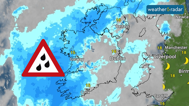
Satellite weather map of Ireland showing widespread rain bands and extensive precipitation, with a heavy rain warning symbol, temperatures around 15 to 16 °C, and cloud cover over much of the country.
Overnight, heavy and fairly widespread rain moves through.

Weather warnings have been issued across the south of Ireland from this evening, with heavy rain expected to pass through overnight into Friday.

Covering counties Cork, Kerry, and Waterford, the yellow warnings come into effect from 09:00 pm, though showers will be passing through earlier than this, some of them heavy.

More persistent rainfall then arrives in the evening, lasting into Friday morning before the warnings expire at 09:00 am.

Ryan Hathaway

More on the topic

Conditions combine to reduce air quality. Light winds and fireworks. . . Tuesday, 10 November 2026
Split image showing a UK wind map with 25 mph near Cardiff and 19 mph near London, beside colourful fireworks above illuminated waterfront buildings.
Tuesday, 10 November 2026

Light winds and fireworks

Conditions combine to reduce air quality
Foggy mornings and crisp autumn days. Your weather - Your shots. . . Sunday, 8 November 2026
Sunday, 8 November 2026

Your weather - Your shots

Foggy mornings and crisp autumn days
Further fog disruption expected. Growing dense overnight. . . Monday, 9 November 2026
Weather map showing widespread fog across the English Midlands, with a red fog warning symbol near Nottingham and temperatures of 4–6°C.
Monday, 9 November 2026

Growing dense overnight

Further fog disruption expected
All weather news

This might also interest you

Super Typhoon Bavi threatens Taiwan. Up to 1,000 mm of rain. . . Wednesday, 8 July 2026
The image shows an intense tropical cyclone over the western Pacific, east of Taiwan and the Philippines. The centre of the system is depicted as a light purple and white vortex with a clearly visible eye, surrounded by a ring of red and orange areas indicating the strongest wind speeds. A white arrow marks the typhoon’s predicted track towards the north-west, in the direction of Taiwan. To the west of the storm lie the Philippines, with the cities of Manila and Cebu; to the north of these lies Taiwan, with Taipei. Further west, the Chinese coast, including Hong Kong, and parts of Vietnam can be seen. The coloured wind map shows predominantly green areas outside the storm’s core, indicating significantly weaker winds. White streamlines illustrate the typhoon’s anti-clockwise circulation in the Northern Hemisphere. The highest wind speeds are concentrated around the eye of the cyclone.
Wednesday, 8 July 2026

Up to 1,000 mm of rain

Super Typhoon Bavi threatens Taiwan
New records for England and Wales. Broken again tomorrow?. . . Thursday, 25 June 2026
Temperature map of southwest Britain on 25.06 showing extreme heat across southern Wales and southwest England, with Bute Park in Cardiff highlighted at 34.2°C and Yeovilton at 36.4°C amid widespread deep red heat zones.
Thursday, 25 June 2026

Broken again tomorrow?

New records for England and Wales
Bright and warm conditions take hold. Spring-like outlook. . . Thursday, 23 April 2026
Split UK map showing warm temperatures up to 21 degrees in orange on the left and clear sunny conditions with temperatures from 12 to 18 degrees on the right, with sun icons across the country.
Thursday, 23 April 2026

Spring-like outlook

Bright and warm conditions take hold
All articles
Weather & Radar

Weather & Radar is also available on

Google Play StoreApp Store

Company

Contact us Privacy Policy Legal info Accessibility statement

Services

Uploader

Socials

facebooktwittertikToklinkList