Home
Weather London
WeatherRadar
RainfallRadar
TemperatureRadar
WindRadar
LightningRadar
Weather News
Editor's Pick
Discover the app
Weather widget
Contact us
Apps
Career
    Home / Editor's Pick /

    Over the coming days - Jet stream brings unsettled weather to western and central Europe

15:34
11 September 2025

Over the coming days
Jet stream brings unsettled weather

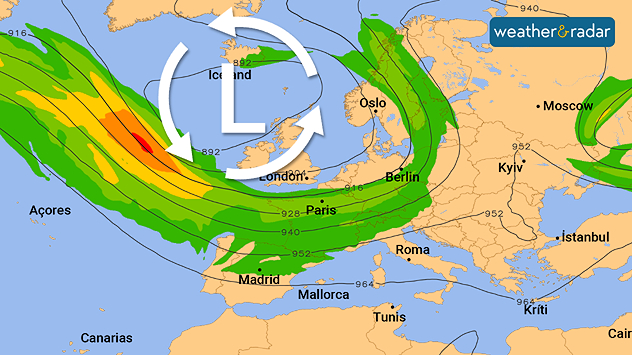
Weather map showing low pressure over Iceland and jet stream over Europe.
The jet stream is located directly above Western and Central Europe.

The changeable weather will continue across large parts of western and Central Europe due to the jet stream.

The band of strong winds at an altitude of 10 kilometres acts as a highway for low-pressure systems, sending one low-pressure system after another across the continent.

Changeable showery weather will therefore prevail over the weekend from the UK and Ireland, to France, onwards to Germany and Scandinavia. In addition, there will often be brisk to strong winds. With temperatures frequently below 20 degrees, there will be no sign of summer weather to start autumn.

Dennis Oswald
Ryan Hathaway

More on the topic

Overnight impacts as Austen hits. Power cuts, travel issues. . . Friday, 23 October 2026
Split image showing floodwater surging beneath a railway bridge at night and a wind map with low pressure over the English Channel and 60 mph near Brest.
Friday, 23 October 2026

Power cuts, travel issues

Overnight impacts as Austen hits
Preparing for the storms. What to do now. . . Thursday, 22 October 2026
Split image showing Storm Austen winds up to 65 mph near Brest and 55 mph near Plymouth, alongside fallen tree branches on a cordoned-off park path.
Thursday, 22 October 2026

What to do now

Preparing for the storms
Storm Boelo named. Weekend impacts. . . Thursday, 22 October 2026
Split weather maps showing Storm Boelo northwest of Scotland, winds reaching 50 mph near Glasgow and Liverpool, and spiralling Atlantic rain bands.
Thursday, 22 October 2026

Weekend impacts

Storm Boelo named
All weather news

This might also interest you

Historic Storm Éowyn arrives. On this day.... . . Saturday, 24 January 2026
Split image showing a person in a yellow jacket struggling against strong winds and heavy rain on a street at night on the left, and an Irish wind forecast map on the right with red and purple shading, gusts up to 75 mph, and a wind warning icon, divided by a curved white line.
Saturday, 24 January 2026

On this day...

Historic Storm Éowyn arrives
Flooding, gales, and heavy snow. Storm Chandra. . . Tuesday, 27 January 2026
Split image showing aerial flooding in a town with muddy water covering roads on the left, and a rural road on the right blocked by heavy snowfall with vans stopped and a person walking in snow.
Tuesday, 27 January 2026

Storm Chandra

Flooding, gales, and heavy snow
Long-term trends need a pinch of salt. 40 °C in July?. . . Tuesday, 30 June 2026
Temperature radar of 2022 heatwave where the all-time temperature record in the UK was set. Warning symbol overlain.
Tuesday, 30 June 2026

40 °C in July?

Long-term trends need a pinch of salt
All articles
Weather & Radar

Weather & Radar is also available on

Google Play StoreApp Store

Company

Contact us Privacy Policy Legal info Accessibility statement

Services

Uploader

Socials

facebooktwittertikToklinkList