Home
Weather London
WeatherRadar
RainfallRadar
TemperatureRadar
WindRadar
LightningRadar
Weather News
Editor's Pick
Discover the app
Weather widget
Contact us
Apps
Career
    Home / Editor's Pick /

    Over the coming days - Chance of thundery showers breaking out

14:17
18 August 2026

Over the coming days
Chance of thundery showers breaking out

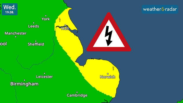
Weather warning map for Wednesday 19.08 showing yellow thunderstorm risk areas along eastern England from near Hull to Norwich, with a lightning warning symbol.
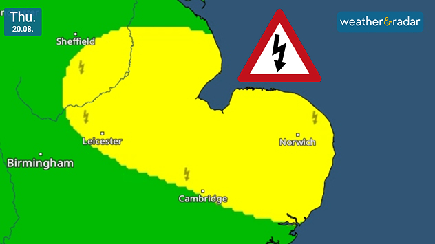
Weather warning map for Thursday 20.08 showing a broad yellow thunderstorm risk area across eastern England, including Leicester, Cambridge and Norwich, with a lightning warning symbol.
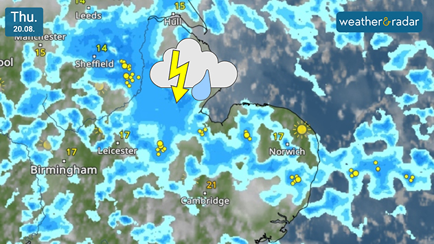
Weather radar map for Thursday 20.08 showing widespread showers and thunderstorms across eastern England, with lightning strikes around Sheffield, Leicester, Cambridge and Norwich.
1/3
Warnings in the app hug the east coast of England initially.

Parts of eastern England may see outbreaks of thundery showers from Wednesday with our own warnings covering the east coast before moving more inland.

On Wednesday, the risk of outbreaks rests predominantly across the east coast of England, in a stretch from Bridlington to Leiston, north-east of Ipswich which is not covered.

By Thursday, the risk extends into the East Midlands, as far as Derbyshire as continued showers hold the potential to bring short-lived thunder and lightning.

Ryan Hathaway
More on the topic
Hurricane Lowell threatens Hawaii. Gales and flash floods. . . Tuesday, 8 September 2026
WindRadar showing Hurricane Lowell north-west of Hawaii and its well-defined storm centre.
Tuesday, 8 September 2026

Gales and flash floods

Hurricane Lowell threatens Hawaii
A marked change in the weather. Cold front heading south. . . Monday, 7 September 2026
Map of Europe showing a cold front stretching from Scandinavia to Spain. Thunderstorms are shown in southern and central Europe.
Monday, 7 September 2026

Cold front heading south

A marked change in the weather
Autumn colours light the skies. Your weather - Your shots. . . Sunday, 13 September 2026
Split image showing a fiery red-orange sunset over a rural road and fields beside a golden sea sunset with a silhouetted seabird in flight.
Sunday, 13 September 2026

Your weather - Your shots

Autumn colours light the skies
All weather news
This might also interest you
A frozen start to the weekend. Icy conditions. . . Friday, 13 February 2026
UK temperature map dated 14.02 showing widespread subzero values in blue shading, with readings such as −4 in Glasgow, −3 in Dublin, and −2 in London, alongside a blue thermometer icon.
Friday, 13 February 2026

Icy conditions

A frozen start to the weekend
A stormy week in the skies above. Your weather - Your shots. . . Sunday, 30 August 2026
Split image showing lightning branching beneath dark storm clouds above rooftops on the left and an orange-pink sunset over a calm sea on the right.
Sunday, 30 August 2026

Your weather - Your shots

A stormy week in the skies above
New records for England and Wales. Broken again tomorrow?. . . Thursday, 25 June 2026
Temperature map of southwest Britain on 25.06 showing extreme heat across southern Wales and southwest England, with Bute Park in Cardiff highlighted at 34.2°C and Yeovilton at 36.4°C amid widespread deep red heat zones.
Thursday, 25 June 2026

Broken again tomorrow?

New records for England and Wales
All articles
Weather & Radar

Weather & Radar is also available on

Google Play StoreApp Store

Company

Contact us Privacy Policy Legal info Accessibility statement

Services

Uploader

Socials

facebooktwittertikToklinkList