Home
Weather London
WeatherRadar
RainfallRadar
TemperatureRadar
WindRadar
LightningRadar
Weather News
Editor's Pick
Discover the app
Weather widget
Contact us
Apps
Career
    Home / Editor's Pick /

    On this day... The 2004 Boxing Day tsunami

09:00
26 December 2025

On this day...
The 2004 Boxing Day tsunami

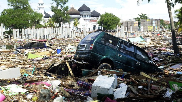
Tsunami damage
The scene 19 years ago in Aceh, Indonesia in the aftermath of the 2004 Boxing Day tsunami. - © picture alliance

21 years ago today, a powerful 9.1 Magnitude earthquake struck off the coast of Sumatra, Indonesia, causing a catastrophic and deadly tsunami.

The earthquake, which lasted for an unrelenting 10 hours, ruptured a 900-mile fault line on the Indian-Australian tectonic plate boundary, causing the seafloor to rise by 40 metres, triggering the colossal tsunami.

Within 20 minutes, 100-foot waves had crashed into Banda Aceh, Indonesia, killing over 170,000 people and turning the city to rubble.

Over the next two hours, the tsunami sent 500 mph waves slamming into Thailand, India, and Sri Lanka, killing thousands more. After eight hours, deaths even occurred in South Africa after strong waves and swells caught swimmers by surprise.

Overall, nearly 230,000 people were killed in what remains one of the most-deadliest natural disasters in history.

The earthquake responsible for triggering the tsunami became the most powerful quake in the 21st century and the third-largest in recorded history.

Around £5.7 billion in aid was provided to the affected countries, raised by the Indonesian government, charity projects, private donors, and NGOs.

A tsunami is a natural disaster caused by earthquakes which hit at sea and cause a large displacement of water.

The name originates in Japan, a country which regularly sees tsunamis due to its position on the Ring of Fire. The tsunami of Boxing Day 2004 remains the worst instance in history.

Ryan Hathaway
More on the topic
Heat becoming a bigger factor in drought. New study. . . Thursday, 23 July 2026
A hand holds dry, dusty earth above a parched field. The ground is cracked and covered with plant debris – a sign of prolonged drought.
Thursday, 23 July 2026

New study

Heat becoming a bigger factor in drought
Forest fires are getting out of control. Spain and France. . . Saturday, 25 July 2026
A split-screen image featuring a photograph and a weather map. On the left, thick, dark-grey smoke rises from several fire sites in a wooded coastal area; a calm stretch of water can be seen in the foreground. On the right, a weather map shows south-western France and northern Spain. A red arrow points from the Atlantic towards the French Atlantic coast, symbolising an onshore wind. Sunny weather is forecast for Bordeaux at around 20 degrees, and Bilbao is also expected to be sunny at around 27 degrees. A large warning sign with a flame symbol indicates an increased risk of forest fires.
Saturday, 25 July 2026

Spain and France

Forest fires are getting out of control
Fourth heatwave of the year. Peaking Wednesday. . . Tuesday, 28 July 2026
Temperature map of England and Wales on Wednesday 29.07 showing widespread hot conditions, with temperatures reaching 33°C near Cambridge, 32°C around London, Norwich, and Southend-on-Sea, and a large heat warning symbol highlighting elevated heat risk.
Tuesday, 28 July 2026

Peaking Wednesday

Fourth heatwave of the year
All weather news
This might also interest you
Super Typhoon Bavi threatens Taiwan. Up to 1,000 mm of rain. . . Wednesday, 8 July 2026
The image shows an intense tropical cyclone over the western Pacific, east of Taiwan and the Philippines. The centre of the system is depicted as a light purple and white vortex with a clearly visible eye, surrounded by a ring of red and orange areas indicating the strongest wind speeds. A white arrow marks the typhoon’s predicted track towards the north-west, in the direction of Taiwan. To the west of the storm lie the Philippines, with the cities of Manila and Cebu; to the north of these lies Taiwan, with Taipei. Further west, the Chinese coast, including Hong Kong, and parts of Vietnam can be seen. The coloured wind map shows predominantly green areas outside the storm’s core, indicating significantly weaker winds. White streamlines illustrate the typhoon’s anti-clockwise circulation in the Northern Hemisphere. The highest wind speeds are concentrated around the eye of the cyclone.
Wednesday, 8 July 2026

Up to 1,000 mm of rain

Super Typhoon Bavi threatens Taiwan
Flooding, gales, and heavy snow. Storm Chandra. . . Tuesday, 27 January 2026
Split image showing aerial flooding in a town with muddy water covering roads on the left, and a rural road on the right blocked by heavy snowfall with vans stopped and a person walking in snow.
Tuesday, 27 January 2026

Storm Chandra

Flooding, gales, and heavy snow
Historic Storm Éowyn arrives. On this day.... . . Saturday, 24 January 2026
Split image showing a person in a yellow jacket struggling against strong winds and heavy rain on a street at night on the left, and an Irish wind forecast map on the right with red and purple shading, gusts up to 75 mph, and a wind warning icon, divided by a curved white line.
Saturday, 24 January 2026

On this day...

Historic Storm Éowyn arrives
All articles
Weather & Radar

Weather & Radar is also available on

Google Play StoreApp Store

Company

Contact us Privacy Policy Legal info Accessibility statement

Services

Uploader

Socials

facebooktwittertikToklinkList