Home
Weather London
WeatherRadar
RainfallRadar
TemperatureRadar
WindRadar
LightningRadar
Weather News
Editor's Pick
Discover the app
Weather widget
Contact us
Apps
Career
    Home / Weather News /

    On this day... - Historic Storm Éowyn arrives

07:00
24 January 2026

On this day...
Historic Storm Éowyn arrives

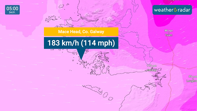
Wind forecast map over western Ireland highlighting Mace Head, County Galway, with a label showing 183 km/h (114 mph), pink and purple shading for extreme winds, and a timestamp of 05:00 on 24.01.
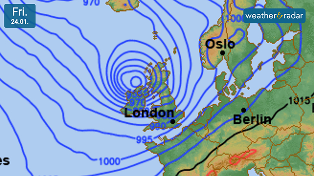
Synoptic weather chart dated Fri 24.01 showing tightly packed blue isobars spiraling around a deep low pressure system west of the UK, with pressure values near 955 mb and labels for London, Oslo, and Berlin.
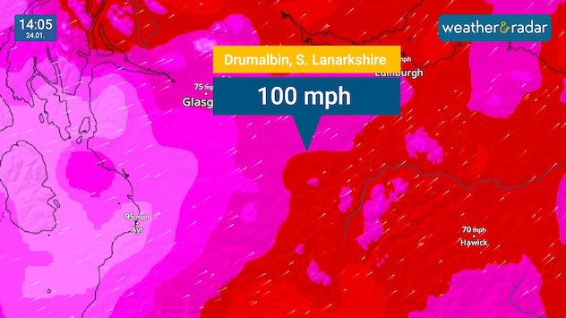
Wind map showing a gust of 100 mph at Drumalbin Scotland during Storm Éowyn in January 2025.
A fallen tree blocks the road in Belfast, Northern Ireland.
1/4
A new record wind gust of 183 km/h (114 mph) was recorded in Ireland as Éowyn arrived.

One year ago today, Storm Éowyn arrived in Ireland as the strongest storm in over a decade. Unleashing hurricane force winds and destruction that some areas are still recovering from.

Weather & Radar were on the scene in the west of Ireland, capturing footage on the ground while reporting on all the impacts across the country and in the UK.

Captured at the scene

Two members of the Weather & Radar team were located at County Clare for the event. Bringing updates through the day.

Starting in the early morning as the system sweeped in.

Through to the afternoon picture as Éowyn began to ease, but more impacts were being uncovered.

The day ended with more than a million properties reporting power cuts, record wind gusts, and widespread property damage.

January 2025: Storm Éowyn live coverageread more
Ryan Hathaway
More on the topic
Severe weather in southern Europe. Thunderstorms & heavy rain. . . Wednesday, 9 September 2026
On the left, dark storm clouds over a coastline. On the right, a weather map shows thunderstorms over the western Mediterranean, with warning symbols for tornadoes, storms and hail.
Wednesday, 9 September 2026

Thunderstorms & heavy rain

Severe weather in southern Europe
Extreme weather contrasts in Europe. Heat versus constant rain. . . Thursday, 3 September 2026
On the left, the Temperature Radar shows high temperatures in Spain; on the right, the Weather Radar shows rain in Central Europe
Thursday, 3 September 2026

Heat versus constant rain

Extreme weather contrasts in Europe
A marked change in the weather. Cold front heading south. . . Monday, 7 September 2026
Map of Europe showing a cold front stretching from Scandinavia to Spain. Thunderstorms are shown in southern and central Europe.
Monday, 7 September 2026

Cold front heading south

A marked change in the weather
All weather news
This might also interest you
Turbulent weather in the Canary Islands. Storm and rain. . . Friday, 12 December 2025
Weather graphic showing rain and wind fields over the Canary Islands and a central warning symbol.
Friday, 12 December 2025

Storm and rain

Turbulent weather in the Canary Islands
A stormy week in the skies above. Your weather - Your shots. . . Sunday, 30 August 2026
Split image showing lightning branching beneath dark storm clouds above rooftops on the left and an orange-pink sunset over a calm sea on the right.
Sunday, 30 August 2026

Your weather - Your shots

A stormy week in the skies above
New records for England and Wales. Broken again tomorrow?. . . Thursday, 25 June 2026
Temperature map of southwest Britain on 25.06 showing extreme heat across southern Wales and southwest England, with Bute Park in Cardiff highlighted at 34.2°C and Yeovilton at 36.4°C amid widespread deep red heat zones.
Thursday, 25 June 2026

Broken again tomorrow?

New records for England and Wales
All articles
Weather & Radar

Weather & Radar is also available on

Google Play StoreApp Store

Company

Contact us Privacy Policy Legal info Accessibility statement

Services

Uploader

Socials

facebooktwittertikToklinkList