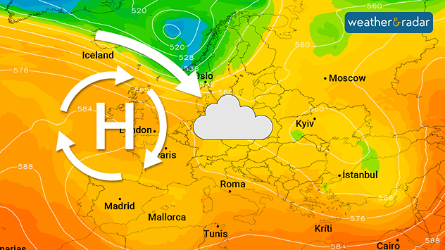
Home
Weather London
WeatherRadar
RainfallRadar
TemperatureRadar
WindRadar
LightningRadar
Weather News
Editor's Pick
Discover the app
Weather widget
Contact us
Apps
Career
Home / Editor's Pick /

Omega block: Pressure over UK shapes Europe's weather

09:00
8 October 2025

Omega block
Pressure over UK shapes Europe's weather

A large area of high pressure over north-western Europe will become established in the coming days.

A strong area of high pressure will build over the UK and Ireland over the next few days, bringing calm autumn weather to many parts of western and Central Europe.

However, it will not be sunny everywhere. Clouds will be a common sight, especially in Denmark, Germany, Benelux, and Poland.

The reason for this is moist air from the Atlantic and the North Sea, which flows into the regions with a north-westerly wind.

In contrast to the summer months, however, it is not sunny everywhere at this time of year despite the high pressure. Instead, thick patches of high fog often persist.

Hamburg

We
4
13
Th
4
11
Fr
0
15
Sa
7
8
Su
6
9
Mo
6
15
Tu
5
13
We
5
13
Th
7
15
Fr
7
16
Sa
7
17
Su
8
16
Mo
6
15
Tu
5
14
Max (°C)
Min (°C)
moreless

Amsterdam

We
8
19
Th
7
12
Fr
7
18
Sa
6
14
Su
6
14
Mo
4
11
Tu
5
13
We
8
16
Th
8
16
Fr
9
17
Sa
9
17
Su
8
16
Mo
8
16
Tu
7
16
Max (°C)
Min (°C)
moreless

Poznań

We
-1
10
Th
-2
10
Fr
-3
12
Sa
-1
13
Su
6
16
Mo
9
16
Tu
8
16
We
5
13
Th
7
15
Fr
8
16
Sa
7
16
Su
8
16
Mo
4
13
Tu
4
14
Max (°C)
Min (°C)
moreless

Brussels

We
7
22
Th
5
14
Fr
7
19
Sa
5
14
Su
6
14
Mo
4
13
Tu
5
13
We
9
17
Th
8
16
Fr
10
18
Sa
10
18
Su
9
17
Mo
7
16
Tu
8
17
Max (°C)
Min (°C)
moreless
Dennis Oswald
Ryan Hathaway
More on the topic
Split UK map showing warm orange temperatures up to 26 degrees on the left transitioning to cooler green tones around 3 to 5 degrees on the right, with an arrow indicating change.
Wednesday, 8 April 2026

A quick shift

High of the year to a cooler spell
Split weather graphic showing a low-pressure system with tight isobars over the UK on the left and a wind map on the right with strong gusts up to 90 mph, plus a windsock warning icon.
Thursday, 2 April 2026

Gales and blizzards

Storm Dave disrupts Easter weekend
Wind map of the UK and Ireland showing a deep low-pressure system, Storm Dave, with red-orange zones and strong gusts up to 55 mph, plus a windsock warning icon indicating hazardous conditions.
Saturday, 4 April 2026

Severe overnight gales

Storm Dave makes impact
All weather news
This might also interest you
Outline of Santa Claus with a yellow and white hat, "Ho-Ho-Ho" next to the outline above a Christmas tree.
Thursday, 25 December 2025

Merry Christmas!

Wishes from Weather & Radar
Split image showing aerial flooding in a town with muddy water covering roads on the left, and a rural road on the right blocked by heavy snowfall with vans stopped and a person walking in snow.
Tuesday, 27 January 2026

Storm Chandra

Flooding, gales, and heavy snow
plit image showing a double rainbow over a rocky shoreline on the left and sheep grazing in a green field under stormy clouds on the right.
Sunday, 2 November 2025

Your weather - Your shots

Mixed conditions on an unsettled week
All articles
Weather & Radar

Weather & Radar is also available on

Google Play StoreApp Store

Company

Contact us Privacy Policy Legal info Accessibility statement

Services

Uploader

Socials

facebooktwittertikToklinkList