Home
Weather London
WeatherRadar
RainfallRadar
TemperatureRadar
WindRadar
LightningRadar
Weather News
Editor's Pick
Discover the app
Weather widget
Contact us
Apps
Career
    Home / Editor's Pick /

    No maple syrup needed! Ice pancakes form in Denmark

09:57
11 January 2024

No maple syrup needed!
Ice pancakes form in Denmark

It may not be Pancake Day just yet, but we're already starting to see signs of pancakes in other forms as winter kicks in!

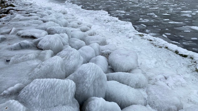
As the video above shows, the deep freeze over parts of Northern Europe in recent days has created special ice called "pancakes" in Denmark. These ones aren't for eating and no amount of maple syrup will help.

Dennis Sonne Mogensen sent us these videos and photos from his walk at Nivå Harbor in Denmark on Wednesday 10th January 2024.

They can form when there is foam on the surface of cold rivers, lakes and oceans. The foam freezes to form ice crystals, and as the current spirals, it causes them to form into a circular disc shape.

The icy, foamy waters also coated the rocks along the shore.
The icy, foamy waters also coated the rocks along the shore. - © Dennis Sonne Mogensen

Another way they can form is when pieces of ice knock into each other growing and freezing, as the waves don't allow for larger ice sheets to form. The ice can also be caused to rotate by melting water sinking or gases rising. These discs can be quite thin, so often break easily if under pressure.

For such ice pancakes to occur, the temperature must be very low for a long period of time. They are most often found in Russia, further north in Scandinavia, Canada and northern parts of the USA. Denmark can also join the list, with their freezing temperatures lately.

The icy phenomenon can also be found more locally in rivers and lakes across parts of Scotland and Northern England in the depths of winter.

Curious how cold it is elsewhere in Europe? Check out our TemperatureRadar.

Ghost apple: more winter creations!read more
More on the topic
Severe weather in the Mediterranean. Is a medicane on the way?. . . Monday, 14 September 2026
A weather map shows a powerful low-pressure system over the Mediterranean, with warning symbols for storms and heavy rain.
Monday, 14 September 2026

Is a medicane on the way?

Severe weather in the Mediterranean
Autumn colours light the skies. Your weather - Your shots. . . Sunday, 13 September 2026
Split image showing a fiery red-orange sunset over a rural road and fields beside a golden sea sunset with a silhouetted seabird in flight.
Sunday, 13 September 2026

Your weather - Your shots

Autumn colours light the skies
Severe weather in southern Europe. Thunderstorms & heavy rain. . . Wednesday, 9 September 2026
On the left, dark storm clouds over a coastline. On the right, a weather map shows thunderstorms over the western Mediterranean, with warning symbols for tornadoes, storms and hail.
Wednesday, 9 September 2026

Thunderstorms & heavy rain

Severe weather in southern Europe
All weather news
This might also interest you
Super Typhoon Bavi threatens Taiwan. Up to 1,000 mm of rain. . . Wednesday, 8 July 2026
The image shows an intense tropical cyclone over the western Pacific, east of Taiwan and the Philippines. The centre of the system is depicted as a light purple and white vortex with a clearly visible eye, surrounded by a ring of red and orange areas indicating the strongest wind speeds. A white arrow marks the typhoon’s predicted track towards the north-west, in the direction of Taiwan. To the west of the storm lie the Philippines, with the cities of Manila and Cebu; to the north of these lies Taiwan, with Taipei. Further west, the Chinese coast, including Hong Kong, and parts of Vietnam can be seen. The coloured wind map shows predominantly green areas outside the storm’s core, indicating significantly weaker winds. White streamlines illustrate the typhoon’s anti-clockwise circulation in the Northern Hemisphere. The highest wind speeds are concentrated around the eye of the cyclone.
Wednesday, 8 July 2026

Up to 1,000 mm of rain

Super Typhoon Bavi threatens Taiwan
Historic Storm Éowyn arrives. On this day.... . . Saturday, 24 January 2026
Split image showing a person in a yellow jacket struggling against strong winds and heavy rain on a street at night on the left, and an Irish wind forecast map on the right with red and purple shading, gusts up to 75 mph, and a wind warning icon, divided by a curved white line.
Saturday, 24 January 2026

On this day...

Historic Storm Éowyn arrives
New records for England and Wales. Broken again tomorrow?. . . Thursday, 25 June 2026
Temperature map of southwest Britain on 25.06 showing extreme heat across southern Wales and southwest England, with Bute Park in Cardiff highlighted at 34.2°C and Yeovilton at 36.4°C amid widespread deep red heat zones.
Thursday, 25 June 2026

Broken again tomorrow?

New records for England and Wales
All articles
Weather & Radar

Weather & Radar is also available on

Google Play StoreApp Store

Company

Contact us Privacy Policy Legal info Accessibility statement

Services

Uploader

Socials

facebooktwittertikToklinkList