Home
Weather London
WeatherRadar
RainfallRadar
TemperatureRadar
WindRadar
LightningRadar
Weather News
Editor's Pick
Discover the app
Weather widget
Contact us
Apps
Career
    Home / Editor's Pick /

    Much warmer bank holiday - Heatwave? We're not quite there yet

08:00
15 May 2026

Much warmer bank holiday
Heatwave? We're not quite there yet

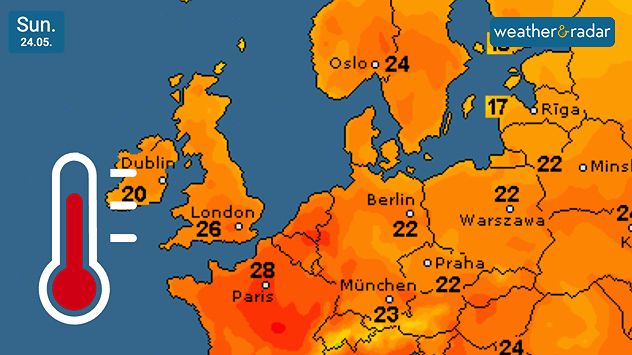
Temperature map of Europe on Sunday 24.05 showing widespread warm orange and red conditions, with temperatures reaching 28°C near Paris and 26°C in London alongside a thermometer icon.
Spring bank holiday weekend brings a much warmer feel, prompting reports of heatwaves.

The late May bank holiday weekend looks set to bring perfect conditions to head outdoors as temperatures rise... but what is this talk of a "mini-heatwave"?

It is true that by next weekend, daily highs could reach up to around 26 °C in south-east England, and widely reaching the low-20s across the UK.

Though enjoyable, this does not constitute a heatwave. The actual temperature needed varies depending on location. In London, one area that may see the 26 °C high, the threshold is 28 °C.

London

Su
10
14
Mo
9
17
Tu
14
16
We
8
16
Th
9
15
Fr
8
14
Sa
10
14
Su
8
14
Mo
9
14
Tu
11
16
We
11
16
Th
10
16
Fr
13
15
Sa
9
14
Max (°C)
Min (°C)
moreless

Cardiff

Su
11
13
Mo
11
16
Tu
12
13
We
10
15
Th
10
14
Fr
9
14
Sa
10
14
Su
7
12
Mo
9
13
Tu
10
13
We
11
13
Th
11
14
Fr
12
13
Sa
9
13
Max (°C)
Min (°C)
moreless

Torquay

Su
11
14
Mo
11
16
Tu
12
15
We
10
16
Th
10
15
Fr
12
14
Sa
9
15
Su
7
13
Mo
9
15
Tu
9
15
We
10
16
Th
10
16
Fr
12
15
Sa
8
14
Max (°C)
Min (°C)
moreless

Manchester

Su
9
11
Mo
7
16
Tu
11
13
We
8
14
Th
10
12
Fr
10
13
Sa
9
13
Su
5
11
Mo
7
11
Tu
8
12
We
9
13
Th
8
13
Fr
9
11
Sa
6
11
Max (°C)
Min (°C)
moreless

Edinburgh

Su
8
11
Mo
7
15
Tu
11
11
We
8
13
Th
7
13
Fr
9
12
Sa
7
13
Su
7
13
Mo
10
13
Tu
7
12
We
8
12
Th
8
12
Fr
7
11
Sa
5
10
Max (°C)
Min (°C)
moreless

Elsewhere, the threshold lays between 25 and 28 degrees, cooler further north. It isn't just the temperature though, it's also the duration of the warmth.

In order to be designated as a heatwave, the threshold must be met for at least three consecutive days.

The "mini-heatwave"? This isn't an official meteorological term, but is often used by media to refer to periods of warmer weather and is a good indicator of a shorter, slightly cooler, burst of warmth.

Ryan Hathaway

More on the topic

Shooting stars from the Orionids peak. Mixed visibility overnight. . . Wednesday, 21 October 2026
Split image showing a bright green meteor streaking across a starry night sky beside a UK weather map with rain over Scotland and southern England.
Wednesday, 21 October 2026

Mixed visibility overnight

Shooting stars from the Orionids peak
Storm Boelo named. Weekend impacts. . . Thursday, 22 October 2026
Split weather maps showing Storm Boelo northwest of Scotland, winds reaching 50 mph near Glasgow and Liverpool, and spiralling Atlantic rain bands.
Thursday, 22 October 2026

Weekend impacts

Storm Boelo named
Overnight impacts as Austen hits. Power cuts, travel issues. . . Friday, 23 October 2026
Split image showing floodwater surging beneath a railway bridge at night and a wind map with low pressure over the English Channel and 60 mph near Brest.
Friday, 23 October 2026

Power cuts, travel issues

Overnight impacts as Austen hits
All weather news

This might also interest you

Long-term trends need a pinch of salt. 40 °C in July?. . . Tuesday, 30 June 2026
Temperature radar of 2022 heatwave where the all-time temperature record in the UK was set. Warning symbol overlain.
Tuesday, 30 June 2026

40 °C in July?

Long-term trends need a pinch of salt
A frozen start to the weekend. Icy conditions. . . Friday, 13 February 2026
UK temperature map dated 14.02 showing widespread subzero values in blue shading, with readings such as −4 in Glasgow, −3 in Dublin, and −2 in London, alongside a blue thermometer icon.
Friday, 13 February 2026

Icy conditions

A frozen start to the weekend
Historic Storm Éowyn arrives. On this day.... . . Saturday, 24 January 2026
Split image showing a person in a yellow jacket struggling against strong winds and heavy rain on a street at night on the left, and an Irish wind forecast map on the right with red and purple shading, gusts up to 75 mph, and a wind warning icon, divided by a curved white line.
Saturday, 24 January 2026

On this day...

Historic Storm Éowyn arrives
All articles
Weather & Radar

Weather & Radar is also available on

Google Play StoreApp Store

Company

Contact us Privacy Policy Legal info Accessibility statement

Services

Uploader

Socials

facebooktwittertikToklinkList