Home
Weather London
WeatherRadar
RainfallRadar
TemperatureRadar
WindRadar
LightningRadar
Weather News
Editor's Pick
Discover the app
Weather widget
Contact us
Apps
Career
    Home / Editor's Pick /

    More than 6 feet of snow: Blizzard conditions impact California

13:00
5 March 2024

More than 6 feet of snow
Blizzard conditions impact California

Weather & Radar reporter Jonathan Petramala in blizzard-hit California.

Blizzard conditions delivered more than six feet of snow in parts of California over recent days as one of the most impactful storms of the year begins to ease.

In the Sierra Nevada and Great Basin, more than six feet of snow fell from Thursday, February 29 to March 3, with higher amounts locally piling on top of what was already in the Sierra Nevada snowpack.

Snow & Winds

Blizzard warnings were issued at least 48 hours in advance of the system's arrival, giving those in the area time to evacuate to safety from the severe conditions.

The northern Sierra was hit hard by snowfall and the blizzard conditions, especially. The highest snow reports are coming out of ski resort Sugar Bowl with 126 inches! Soda Springs Ski Resort also saw 116 inches.

Near Lake Tahoe in Palisades Tahoe Ski Base, winds gusted to 145 mph at 8,700 feet in elevation – Category 4 hurricane strength.

Fighting California's drought

Alongside the snowfall, heavy rain also hit the drought-hit state. Honeydew, north of San Francisco, reported more than 7 inches of rainfall, with half-foot readings being recorded in both northern California, Oregon, and Washington as the storm hit the coast.

The short-term impacts of the heavy rainfall can bring many issues such as flash flooding, mudslides, and landslides, but the long-term impacts will be seen in lesser drought and more water table availability.

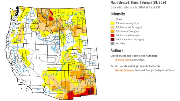
Currently, California is only experiencing abnormally dry conditions in a very small area. Marking a recovery since 2022 where three-quarters of the state was reported to be in extreme or exception drought.

Latest drought update as of February 27, 2024.
Latest drought update as of February 27, 2024. - © National Drought Mitigation Center University of Nebraska-Lincoln

The snowpack in the Sierras should be close if not above its normal water equivalent now that this large storm system has wrapped up. The last overall measurement was on March 1 as the storm was still in place.

The Snow Lab in the central Sierras is already reporting 98% of their median season snow peak.

2022: Western US in historic droughtread more
Weather & Radar editorial team
More on the topic
Parts of England inching towards drought. Low rivers & reservoirs. . . Wednesday, 22 July 2026
People relaxing in a park during hot weather ,with one person sunbathing on dry yellow grass beneath large leafy trees under a blue sky with scattered fair-weather clouds.
Wednesday, 22 July 2026

Low rivers & reservoirs

Parts of England inching towards drought
A wet start before conditions settle. Commonwealth Games 2026. . . Wednesday, 22 July 2026
Split image showing a weather map for western Scotland with widespread rain around Glasgow on the left, and runners poised at a starting line on an athletics track on the right.
Wednesday, 22 July 2026

Commonwealth Games 2026

A wet start before conditions settle
Severe damage along the Adriatic coast. Huge hail and storms. . . Wednesday, 22 July 2026
Two hands are holding huge hailstones; next to them is a weather map showing thunderstorms and frequent lightning over the Adriatic coast and the western Balkans.
Wednesday, 22 July 2026

Huge hail and storms

Severe damage along the Adriatic coast
All weather news
This might also interest you
New records for England and Wales. Broken again tomorrow?. . . Thursday, 25 June 2026
Temperature map of southwest Britain on 25.06 showing extreme heat across southern Wales and southwest England, with Bute Park in Cardiff highlighted at 34.2°C and Yeovilton at 36.4°C amid widespread deep red heat zones.
Thursday, 25 June 2026

Broken again tomorrow?

New records for England and Wales
Super Typhoon Bavi threatens Taiwan. Up to 1,000 mm of rain. . . Wednesday, 8 July 2026
The image shows an intense tropical cyclone over the western Pacific, east of Taiwan and the Philippines. The centre of the system is depicted as a light purple and white vortex with a clearly visible eye, surrounded by a ring of red and orange areas indicating the strongest wind speeds. A white arrow marks the typhoon’s predicted track towards the north-west, in the direction of Taiwan. To the west of the storm lie the Philippines, with the cities of Manila and Cebu; to the north of these lies Taiwan, with Taipei. Further west, the Chinese coast, including Hong Kong, and parts of Vietnam can be seen. The coloured wind map shows predominantly green areas outside the storm’s core, indicating significantly weaker winds. White streamlines illustrate the typhoon’s anti-clockwise circulation in the Northern Hemisphere. The highest wind speeds are concentrated around the eye of the cyclone.
Wednesday, 8 July 2026

Up to 1,000 mm of rain

Super Typhoon Bavi threatens Taiwan
Flooding, gales, and heavy snow. Storm Chandra. . . Tuesday, 27 January 2026
Split image showing aerial flooding in a town with muddy water covering roads on the left, and a rural road on the right blocked by heavy snowfall with vans stopped and a person walking in snow.
Tuesday, 27 January 2026

Storm Chandra

Flooding, gales, and heavy snow
All articles
Weather & Radar

Weather & Radar is also available on

Google Play StoreApp Store

Company

Contact us Privacy Policy Legal info Accessibility statement

Services

Uploader

Socials

facebooktwittertikToklinkList