Home
Weather London
WeatherRadar
RainfallRadar
TemperatureRadar
WindRadar
LightningRadar
Weather News
Editor's Pick
Discover the app
Weather widget
Contact us
Apps
Career
    Home / Editor's Pick /

    More than 100 killed: Cyclone Freddy returns to Africa

12:30
14 March 2023

More than 100 killed
Cyclone Freddy returns to Africa

WindRadar of Cyclone Freddy
Cyclone Freddy seen on the WindRadar this Sunday as it reached Mozambique.

More than 100 people have been killed after Cyclone Freddy returned to southeast Africa at the weekend.

The long-lived cyclone reached the coast of Mozambique on Sunday for the second time. Authorities in the country say that at least 99 were killed in mudslides with others missing.

Freddy previously made landfall in Mozambique in late February causing widespread infrastructure damage impacting over 150,000 people with some areas seeing rainfall amounts up to 500 mm.

Neighbouring Malawi has also felt the impact of the system twice. More than 100 people were killed during the first landfall while at least 85 have perished since the weekend’s second hit.

Power supplies are unstable due to flooding in Malawi and schools will remain shut until Wednesday at least as rain continues to fall in the south.

Both countries are also dealing with a cholera outbreak which has already killed over 1,600 people, efforts to manage this have been severely disrupted by the natural disasters.

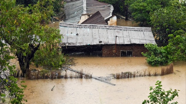
Flooded homes
Damaged road
Mudslide
Cyclone Freddy satellite shot
1/4
Homes in Blantyre, Malawi seen flooded on Tuesday morning. - © picture alliance

Cyclone Freddy formed off the coast of Australia on February 4 and crossed the entirety of the Indian Ocean before making its first major landfall in Madagascar.

Freddy: Longest lasting cyclone everread also

The system has now eased into a low pressure area and is sat in central Mozambique.

A state of Disaster remains in place for southern regions of Malawi, the United Nations is facilitating global efforts to deliver emergency supplies and aid to the countries.

Ryan Hathaway
More on the topic
More rain needed to ease drought. Reservoirs still falling. . . Tuesday, 8 September 2026
Aerial view of a depleted reservoir with exposed banks and a narrow winding stream through the dry basin, surrounded by green hills and roads.
Tuesday, 8 September 2026

Reservoirs still falling

More rain needed to ease drought
A marked change in the weather. Cold front heading south. . . Monday, 7 September 2026
Map of Europe showing a cold front stretching from Scandinavia to Spain. Thunderstorms are shown in southern and central Europe.
Monday, 7 September 2026

Cold front heading south

A marked change in the weather
Hottest summer on record for Ireland. Beating 2025's record. . . Thursday, 3 September 2026
Temperature map of Ireland showing 29°C in Dublin, 26°C in Cork, 24°C in Belfast, and 23°C in Galway, with a red thermometer icon.
Thursday, 3 September 2026

Beating 2025's record

Hottest summer on record for Ireland
All weather news
This might also interest you
Storm Chandra makes impact. Severe gales & heavy rain. . . Tuesday, 27 January 2026
Split image showing strong winds over the UK on a forecast map and widespread rain and snow on a weather radar map.
Tuesday, 27 January 2026

Severe gales & heavy rain

Storm Chandra makes impact
A stormy week in the skies above. Your weather - Your shots. . . Sunday, 30 August 2026
Split image showing lightning branching beneath dark storm clouds above rooftops on the left and an orange-pink sunset over a calm sea on the right.
Sunday, 30 August 2026

Your weather - Your shots

A stormy week in the skies above
Super Typhoon Bavi threatens Taiwan. Up to 1,000 mm of rain. . . Wednesday, 8 July 2026
The image shows an intense tropical cyclone over the western Pacific, east of Taiwan and the Philippines. The centre of the system is depicted as a light purple and white vortex with a clearly visible eye, surrounded by a ring of red and orange areas indicating the strongest wind speeds. A white arrow marks the typhoon’s predicted track towards the north-west, in the direction of Taiwan. To the west of the storm lie the Philippines, with the cities of Manila and Cebu; to the north of these lies Taiwan, with Taipei. Further west, the Chinese coast, including Hong Kong, and parts of Vietnam can be seen. The coloured wind map shows predominantly green areas outside the storm’s core, indicating significantly weaker winds. White streamlines illustrate the typhoon’s anti-clockwise circulation in the Northern Hemisphere. The highest wind speeds are concentrated around the eye of the cyclone.
Wednesday, 8 July 2026

Up to 1,000 mm of rain

Super Typhoon Bavi threatens Taiwan
All articles
Weather & Radar

Weather & Radar is also available on

Google Play StoreApp Store

Company

Contact us Privacy Policy Legal info Accessibility statement

Services

Uploader

Socials

facebooktwittertikToklinkList