Home
Weather London
WeatherRadar
RainfallRadar
TemperatureRadar
WindRadar
LightningRadar
Weather News
Editor's Pick
Discover the app
Weather widget
Contact us
Apps
Career
    Home / Editor's Pick /

    More than 100 killed: Cyclone Freddy returns to Africa

12:30
14 March 2023

More than 100 killed
Cyclone Freddy returns to Africa

WindRadar of Cyclone Freddy
Cyclone Freddy seen on the WindRadar this Sunday as it reached Mozambique.

More than 100 people have been killed after Cyclone Freddy returned to southeast Africa at the weekend.

The long-lived cyclone reached the coast of Mozambique on Sunday for the second time. Authorities in the country say that at least 99 were killed in mudslides with others missing.

Freddy previously made landfall in Mozambique in late February causing widespread infrastructure damage impacting over 150,000 people with some areas seeing rainfall amounts up to 500 mm.

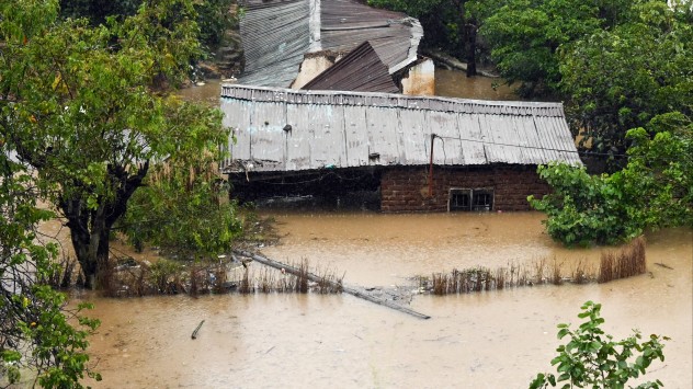
Neighbouring Malawi has also felt the impact of the system twice. More than 100 people were killed during the first landfall while at least 85 have perished since the weekend’s second hit.

Power supplies are unstable due to flooding in Malawi and schools will remain shut until Wednesday at least as rain continues to fall in the south.

Both countries are also dealing with a cholera outbreak which has already killed over 1,600 people, efforts to manage this have been severely disrupted by the natural disasters.

Flooded homes
Damaged road
Mudslide
Cyclone Freddy satellite shot
1/4
Homes in Blantyre, Malawi seen flooded on Tuesday morning. - © picture alliance

Cyclone Freddy formed off the coast of Australia on February 4 and crossed the entirety of the Indian Ocean before making its first major landfall in Madagascar.

Freddy: Longest lasting cyclone everread also

The system has now eased into a low pressure area and is sat in central Mozambique.

A state of Disaster remains in place for southern regions of Malawi, the United Nations is facilitating global efforts to deliver emergency supplies and aid to the countries.

Ryan Hathaway
More on the topic
Half of England now in drought. Joining North Wales. . . Wednesday, 29 July 2026
Dry section of the River Thames beneath a small stone bridge, with the riverbed exposed and cracked after prolonged, dry weather, while a person walks along the roadside above.
Wednesday, 29 July 2026

Joining North Wales

Half of England now in drought
UV levels peak with the heat today. Latest heatwave. . . Wednesday, 29 July 2026
Split graphic showing a temperature map of England and eastern Ireland with temperatures reaching 33°C near London, 32°C in Norwich, and 29°C around Birmingham on the left, alongside a person applying sunscreen with a UV icon on the right.
Wednesday, 29 July 2026

Latest heatwave

UV levels peak with the heat today
Floods and landslides in parts of Asia. An unusual monsoon. . . Wednesday, 29 July 2026
Split image: On the left, flooded villages and fields can be seen in a vast landscape. On the right, a weather map of India shows heavy rainfall, along with a warning sign featuring a car in floodwater.
Wednesday, 29 July 2026

An unusual monsoon

Floods and landslides in parts of Asia
All weather news
This might also interest you
Bright and warm conditions take hold. Spring-like outlook. . . Thursday, 23 April 2026
Split UK map showing warm temperatures up to 21 degrees in orange on the left and clear sunny conditions with temperatures from 12 to 18 degrees on the right, with sun icons across the country.
Thursday, 23 April 2026

Spring-like outlook

Bright and warm conditions take hold
Flooding, gales, and heavy snow. Storm Chandra. . . Tuesday, 27 January 2026
Split image showing aerial flooding in a town with muddy water covering roads on the left, and a rural road on the right blocked by heavy snowfall with vans stopped and a person walking in snow.
Tuesday, 27 January 2026

Storm Chandra

Flooding, gales, and heavy snow
Historic Storm Éowyn arrives. On this day.... . . Saturday, 24 January 2026
Split image showing a person in a yellow jacket struggling against strong winds and heavy rain on a street at night on the left, and an Irish wind forecast map on the right with red and purple shading, gusts up to 75 mph, and a wind warning icon, divided by a curved white line.
Saturday, 24 January 2026

On this day...

Historic Storm Éowyn arrives
All articles
Weather & Radar

Weather & Radar is also available on

Google Play StoreApp Store

Company

Contact us Privacy Policy Legal info Accessibility statement

Services

Uploader

Socials

facebooktwittertikToklinkList