Home
Weather London
WeatherRadar
RainfallRadar
TemperatureRadar
WindRadar
LightningRadar
Weather News
Editor's Pick
Discover the app
Weather widget
Contact us
Apps
Career
    Home / Editor's Pick /

    Mediterranean bathtub - Warm waters raise severe weather risk

11:13
4 September 2026

Mediterranean bathtub
Warm waters raise severe weather risk

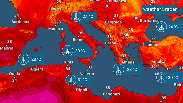
The hot summer has left its mark: the Mediterranean and the Black Sea are both unusually warm.

Particularly around Italy and south of France, the water temperature is 4 to 5 degrees above the long-term average (1991–2020). Only in the far west and east of the Mediterranean are the anomalies significantly smaller.

Extreme heat continues in SpainTemperatureRadar

As autumn approaches, the warm water could become a problem. If low-pressure systems carrying colder air move across the region, severe thunderstorms and heavy rain may develop leading to inevitable flooding.

Between southern Italy and Tunisia, temperatures are reaching 30 to 31°C – almost bathwater temperatures.

Low-pressure systems can absorb a particularly large amount of moisture above very warm water. At the same time, the significant temperature difference between the water and the air provides additional energy, and further fuels severe weather.

Weather & Radar editorial team
More on the topic
Extreme weather contrasts in Europe. Heat versus constant rain. . . Thursday, 3 September 2026
On the left, the Temperature Radar shows high temperatures in Spain; on the right, the Weather Radar shows rain in Central Europe
Thursday, 3 September 2026

Heat versus constant rain

Extreme weather contrasts in Europe
Rain and blustery winds spread. Frontal influence. . . Wednesday, 2 September 2026
Split weather graphic showing widespread rain across the UK and Ireland alongside winds of 25-35 mph, strongest around Cardiff and the south of the UK.
Wednesday, 2 September 2026

Frontal influence

Rain and blustery winds spread
Cheshire Gap produces shower funnel. Local phenomenon. . . Wednesday, 9 September 2026
Weather map showing showers moving southeast from Liverpool toward Birmingham, driven by Cheshire Gap convergence across central England.
Wednesday, 9 September 2026

Local phenomenon

Cheshire Gap produces shower funnel
All weather news
This might also interest you
Flooding, gales, and heavy snow. Storm Chandra. . . Tuesday, 27 January 2026
Split image showing aerial flooding in a town with muddy water covering roads on the left, and a rural road on the right blocked by heavy snowfall with vans stopped and a person walking in snow.
Tuesday, 27 January 2026

Storm Chandra

Flooding, gales, and heavy snow
Historic Storm Éowyn arrives. On this day.... . . Saturday, 24 January 2026
Split image showing a person in a yellow jacket struggling against strong winds and heavy rain on a street at night on the left, and an Irish wind forecast map on the right with red and purple shading, gusts up to 75 mph, and a wind warning icon, divided by a curved white line.
Saturday, 24 January 2026

On this day...

Historic Storm Éowyn arrives
New records for England and Wales. Broken again tomorrow?. . . Thursday, 25 June 2026
Temperature map of southwest Britain on 25.06 showing extreme heat across southern Wales and southwest England, with Bute Park in Cardiff highlighted at 34.2°C and Yeovilton at 36.4°C amid widespread deep red heat zones.
Thursday, 25 June 2026

Broken again tomorrow?

New records for England and Wales
All articles
Weather & Radar

Weather & Radar is also available on

Google Play StoreApp Store

Company

Contact us Privacy Policy Legal info Accessibility statement

Services

Uploader

Socials

facebooktwittertikToklinkList