Home
Weather London
WeatherRadar
RainfallRadar
TemperatureRadar
WindRadar
LightningRadar
Weather News
Editor's Pick
Discover the app
Weather widget
Contact us
Apps
Career
    Home / Editor's Pick /

    May heatwave - Tropical night breaks overnight record

08:23
26 May 2026

May heatwave
Tropical night breaks overnight record

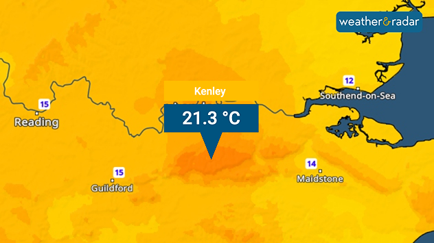
Kenley saw a tropical night, marking another May record.

Monday saw the hottest May day on record, and overnight, another record was set for the hottest May night too.

Temperatures fell to just 21.3 °C in Kenley, within the Croydon borough of London. The warmest recorded in the month, breaking 19.4 °C set just the day before, and officially a tropical night.

Tropical nights mark any night where temperatures do not fall below 20 °C.

After a high of 34.8 °C at Kew Gardens, it is possible that the May daytime record is broken again on Tuesday.

Temperatures of around 35 °C are likely in the south-east of England, with Ireland also forecast highs up to 30 °C after a recording of 28.6 °C on Monday marked the hottest May day in the country.

After this, there is a cooler offering on Wednesday with still warm, but not quite so hot, days for the rest of the week ahead.

Ryan Hathaway

More on the topic

Conditions combine to reduce air quality. Light winds and fireworks. . . Tuesday, 10 November 2026
Split image showing a UK wind map with 25 mph near Cardiff and 19 mph near London, beside colourful fireworks above illuminated waterfront buildings.
Tuesday, 10 November 2026

Light winds and fireworks

Conditions combine to reduce air quality
Autumn is the season for fog. High pressure, but no sun. . . Thursday, 5 November 2026
A split-screen image showing the weather radar for Europe and a mountain landscape. On the right, snow-capped peaks rise above a thick blanket of fog against a blue sky.
Thursday, 5 November 2026

High pressure, but no sun

Autumn is the season for fog
Europe set for a change in the weather. Turning more unsettled. . . Monday, 9 November 2026
European weather map showing low pressure over Scandinavia, pink snow bands across Norway and Sweden, blue rain areas and arrows indicating airflow.
Monday, 9 November 2026

Turning more unsettled

Europe set for a change in the weather
All weather news

This might also interest you

Flooding, gales, and heavy snow. Storm Chandra. . . Tuesday, 27 January 2026
Split image showing aerial flooding in a town with muddy water covering roads on the left, and a rural road on the right blocked by heavy snowfall with vans stopped and a person walking in snow.
Tuesday, 27 January 2026

Storm Chandra

Flooding, gales, and heavy snow
Historic Storm Éowyn arrives. On this day.... . . Saturday, 24 January 2026
Split image showing a person in a yellow jacket struggling against strong winds and heavy rain on a street at night on the left, and an Irish wind forecast map on the right with red and purple shading, gusts up to 75 mph, and a wind warning icon, divided by a curved white line.
Saturday, 24 January 2026

On this day...

Historic Storm Éowyn arrives
A frozen start to the weekend. Icy conditions. . . Friday, 13 February 2026
UK temperature map dated 14.02 showing widespread subzero values in blue shading, with readings such as −4 in Glasgow, −3 in Dublin, and −2 in London, alongside a blue thermometer icon.
Friday, 13 February 2026

Icy conditions

A frozen start to the weekend
All articles
Weather & Radar

Weather & Radar is also available on

Google Play StoreApp Store

Company

Contact us Privacy Policy Legal info Accessibility statement

Services

Uploader

Socials

facebooktwittertikToklinkList