Home
Weather London
WeatherRadar
RainfallRadar
TemperatureRadar
WindRadar
LightningRadar
Weather News
Editor's Pick
Discover the app
Weather widget
Contact us
Apps
Career
    Home / Editor's Pick /

    May heatwave - Tropical night breaks overnight record

08:23
26 May 2026

May heatwave
Tropical night breaks overnight record

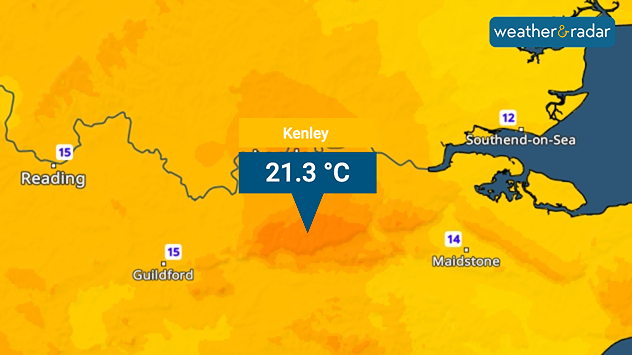
Kenley saw a tropical night, marking another May record.

Monday saw the hottest May day on record, and overnight, another record was set for the hottest May night too.

Temperatures fell to just 21.3 °C in Kenley, within the Croydon borough of London. The warmest recorded in the month, breaking 19.4 °C set just the day before, and officially a tropical night.

Tropical nights mark any night where temperatures do not fall below 20 °C.

After a high of 34.8 °C at Kew Gardens, it is possible that the May daytime record is broken again on Tuesday.

Temperatures of around 35 °C are likely in the south-east of England, with Ireland also forecast highs up to 30 °C after a recording of 28.6 °C on Monday marked the hottest May day in the country.

After this, there is a cooler offering on Wednesday with still warm, but not quite so hot, days for the rest of the week ahead.

Ryan Hathaway
More on the topic
Cooler nights and lower dew points. Less oppressive heatwave. . . Thursday, 9 July 2026
Split image showing the London skyline in hazy golden sunset light in the left and an overnight temperature map of the UK and Ireland on the right, with minimum temperatures ranging from 13°C in northeast Scotland to 18°C in southern England.
Thursday, 9 July 2026

Less oppressive heatwave

Cooler nights and lower dew points
Very high UV levels during the heatwave. Sun cream at the ready!. . . Wednesday, 8 July 2026
Split graphic showing a UK temperature map with hot conditions across England and Wales, temperatures reaching 32 °C near London, and a UV warning icon on the left, alongside a person applying sunscreen in bright sunshine on the right.
Wednesday, 8 July 2026

Sun cream at the ready!

Very high UV levels during the heatwave
Yet another typhoon in the Pacific. Gusts of over 185 mph. . . Friday, 3 July 2026
Wind forecast map of the western Pacific showing a powerful typhoon east of Guam with a well-defined eye, strong wind circulation, and a windsock warning icon.
Friday, 3 July 2026

Gusts of over 185 mph

Yet another typhoon in the Pacific
All weather news
This might also interest you
Bright and warm conditions take hold. Spring-like outlook. . . Thursday, 23 April 2026
Split UK map showing warm temperatures up to 21 degrees in orange on the left and clear sunny conditions with temperatures from 12 to 18 degrees on the right, with sun icons across the country.
Thursday, 23 April 2026

Spring-like outlook

Bright and warm conditions take hold
Historic Storm Éowyn arrives. On this day.... . . Saturday, 24 January 2026
Split image showing a person in a yellow jacket struggling against strong winds and heavy rain on a street at night on the left, and an Irish wind forecast map on the right with red and purple shading, gusts up to 75 mph, and a wind warning icon, divided by a curved white line.
Saturday, 24 January 2026

On this day...

Historic Storm Éowyn arrives
Super Typhoon Bavi threatens Taiwan. Up to 1,000 mm of rain. . . Wednesday, 8 July 2026
The image shows an intense tropical cyclone over the western Pacific, east of Taiwan and the Philippines. The centre of the system is depicted as a light purple and white vortex with a clearly visible eye, surrounded by a ring of red and orange areas indicating the strongest wind speeds. A white arrow marks the typhoon’s predicted track towards the north-west, in the direction of Taiwan. To the west of the storm lie the Philippines, with the cities of Manila and Cebu; to the north of these lies Taiwan, with Taipei. Further west, the Chinese coast, including Hong Kong, and parts of Vietnam can be seen. The coloured wind map shows predominantly green areas outside the storm’s core, indicating significantly weaker winds. White streamlines illustrate the typhoon’s anti-clockwise circulation in the Northern Hemisphere. The highest wind speeds are concentrated around the eye of the cyclone.
Wednesday, 8 July 2026

Up to 1,000 mm of rain

Super Typhoon Bavi threatens Taiwan
All articles
Weather & Radar

Weather & Radar is also available on

Google Play StoreApp Store

Company

Contact us Privacy Policy Legal info Accessibility statement

Services

Uploader

Socials

facebooktwittertikToklinkList