Home
Weather London
WeatherRadar
RainfallRadar
TemperatureRadar
WindRadar
LightningRadar
Weather News
Editor's Pick
Discover the app
Weather widget
Contact us
Apps
Career
    Home / Editor's Pick /

    Marked change in temperature in Europe – summer is coming to an end

08:00
19 August 2025

High summer bids farewell
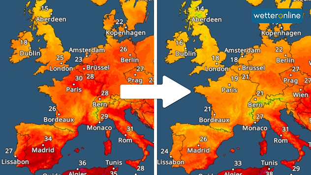
Temperature changes in Europe

Two-part map of Europe showing temperature distribution: on the left, high temperatures above 30°C in France, Germany and Italy; on the right, significantly cooler with temperatures below 20°C in London, Brussels and Amsterdam. A white arrow between the maps marks the change in temperature.
Temperature radar: The midsummer heat is noticeably subsiding. After reaching temperatures of around 30 degrees in some places, it is cooling down significantly in Western Europe.

A significant change in temperature is affecting large parts of Europe this week. Today, peak temperatures of around 30 degrees will be reached from northern Spain to France and the Benelux countries, while tomorrow the maximum temperatures will only reach between 18 and 22 degrees.

Even in the western Mediterranean and, from midweek onwards, in Italy, the extreme heat with temperatures around or above 35 degrees is over. At night, it finally cools down there and in the afternoon it rises to a more bearable 30 degrees.

Cooler air will also reach the Balkans and Eastern Europe by the weekend. In Greece and Turkey, however, it is likely to remain hot for longer.

Tommy Kühnlein
More on the topic
Fourth heatwave of the year. Peaking Wednesday. . . Tuesday, 28 July 2026
Temperature map of England and Wales on Wednesday 29.07 showing widespread hot conditions, with temperatures reaching 33°C near Cambridge, 32°C around London, Norwich, and Southend-on-Sea, and a large heat warning symbol highlighting elevated heat risk.
Tuesday, 28 July 2026

Peaking Wednesday

Fourth heatwave of the year
Clouds return to capture the scene. Your weather - Your shots. . . Sunday, 26 July 2026
Waxing crescent Moon above vivid pink and magenta sunset clouds, with silhouetted trees along the horizon beneath a deepening blue twilight sky.
Sunday, 26 July 2026

Your weather - Your shots

Clouds return to capture the scene
Drought for North Wales and Upper Severn. 2% of average rainfall. . . Thursday, 23 July 2026
Split image showing a July rainfall anomaly map of Europe on the left with below-average rainfall across the UK, Ireland, and much of western and central Europe, and an active moorland wildfire on the right producing flames and thick smoke near homes.
Thursday, 23 July 2026

2% of average rainfall

Drought for North Wales and Upper Severn
All weather news
This might also interest you
A frozen start to the weekend. Icy conditions. . . Friday, 13 February 2026
UK temperature map dated 14.02 showing widespread subzero values in blue shading, with readings such as −4 in Glasgow, −3 in Dublin, and −2 in London, alongside a blue thermometer icon.
Friday, 13 February 2026

Icy conditions

A frozen start to the weekend
Seasonal warmth between spring thunder. Your weather - Your shots. . . Sunday, 19 April 2026
Split image showing coastal sunset with layered lenticular clouds over rooftops and palm trees on the left, and a green valley with river and hills under soft daylight on the right.
Sunday, 19 April 2026

Your weather - Your shots

Seasonal warmth between spring thunder
Long-term trends need a pinch of salt. 40 °C in July?. . . Tuesday, 30 June 2026
Temperature radar of 2022 heatwave where the all-time temperature record in the UK was set. Warning symbol overlain.
Tuesday, 30 June 2026

40 °C in July?

Long-term trends need a pinch of salt
All articles
Weather & Radar

Weather & Radar is also available on

Google Play StoreApp Store

Company

Contact us Privacy Policy Legal info Accessibility statement

Services

Uploader

Socials

facebooktwittertikToklinkList