Home
Weather London
WeatherRadar
RainfallRadar
TemperatureRadar
WindRadar
LightningRadar
Weather News
Editor's Pick
Discover the app
Weather widget
Contact us
Apps
Career
    Home / Editor's Pick /

    Marked change in temperature in Europe – summer is coming to an end

08:00
19 August 2025

High summer bids farewell
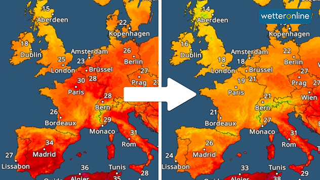
Temperature changes in Europe

Two-part map of Europe showing temperature distribution: on the left, high temperatures above 30°C in France, Germany and Italy; on the right, significantly cooler with temperatures below 20°C in London, Brussels and Amsterdam. A white arrow between the maps marks the change in temperature.
Temperature radar: The midsummer heat is noticeably subsiding. After reaching temperatures of around 30 degrees in some places, it is cooling down significantly in Western Europe.

A significant change in temperature is affecting large parts of Europe this week. Today, peak temperatures of around 30 degrees will be reached from northern Spain to France and the Benelux countries, while tomorrow the maximum temperatures will only reach between 18 and 22 degrees.

Even in the western Mediterranean and, from midweek onwards, in Italy, the extreme heat with temperatures around or above 35 degrees is over. At night, it finally cools down there and in the afternoon it rises to a more bearable 30 degrees.

Cooler air will also reach the Balkans and Eastern Europe by the weekend. In Greece and Turkey, however, it is likely to remain hot for longer.

Tommy Kühnlein
More on the topic
Split image showing a European weather map with low-pressyre system, temperature bands, and thunderstorm icon on the left, and a bright rainbow over green countryside and mountains on the right.
Wednesday, 27 May 2026

Early summer ends

A change in the weather is on the way
Weather warning map of Wales and western Britain showing a yellow thunderstorm alert with lightning symbols, alongside a large warning triangle for lightning.
Wednesday, 27 May 2026

Wales & western England

Thunderstorm watch continues
v
Thursday, 28 May 2026

Gusts exceeding 124 mph

Typhoon risk in the Western Pacific
All weather news
This might also interest you
Split image showing a person in a yellow jacket struggling against strong winds and heavy rain on a street at night on the left, and an Irish wind forecast map on the right with red and purple shading, gusts up to 75 mph, and a wind warning icon, divided by a curved white line.
Saturday, 24 January 2026

On this day...

Historic Storm Éowyn arrives
Split image showing aerial flooding in a town with muddy water covering roads on the left, and a rural road on the right blocked by heavy snowfall with vans stopped and a person walking in snow.
Tuesday, 27 January 2026

Storm Chandra

Flooding, gales, and heavy snow
Split UK map showing warm temperatures up to 21 degrees in orange on the left and clear sunny conditions with temperatures from 12 to 18 degrees on the right, with sun icons across the country.
Thursday, 23 April 2026

Spring-like outlook

Bright and warm conditions take hold
All articles
Weather & Radar

Weather & Radar is also available on

Google Play StoreApp Store

Company

Contact us Privacy Policy Legal info Accessibility statement

Services

Uploader

Socials

facebooktwittertikToklinkList